
Doubtbach
|
Doubtbach
Reinstädt municipality
Coordinates: 50 ° 48 ′ 24 ″ N , 11 ° 30 ′ 19 ″ E
|
||
|---|---|---|
| Height : | 235 m above sea level NN | |
| Incorporation : | 1st October 1970 | |
| Postal code : | 07768 | |
| Area code : | 036422 | |
Location of Zweifelbach in Thuringia |
||
 View from the Kugelsberg
|
||

The hamlet Zweifelbach is a district of Reinstädt in the Saale-Holzland district in Thuringia .
geography
Doubtbach is located in Reinstädter Grund south of the county road 208 from Kahla towards Blankenhain . The ball and Hopfenberg lie south of Feldmark and limit the wooded district of the hamlet. The Reinstädter Bach runs north of the village in the valley.
history
The village was first mentioned on November 18, 1344.
After the German reunification , the farmers joined the agricultural cooperative Reinstädter Grund eG.

The milk bank in the center

The bowling alley
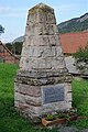
War memorial on the bowling alley


Web links
Commons : Zweifelbach - collection of images, videos and audio files
Individual evidence
- ^ Wolfgang Kahl : First mention of Thuringian towns and villages. A manual. 5th, improved and considerably enlarged edition. Rockstuhl, Bad Langensalza 2010, ISBN 978-3-86777-202-0 , p. 328.