
Golmsdorf
| coat of arms | Germany map | |
|---|---|---|

|
Coordinates: 50 ° 58 ' N , 11 ° 40' E |
|
| Basic data | ||
| State : | Thuringia | |
| County : | Saale-Holzland district | |
| Management Community : | Dornburg-Camburg | |
| Height : | 140 m above sea level NHN | |
| Area : | 7.63 km 2 | |
| Residents: | 698 (Dec. 31, 2019) | |
| Population density : | 91 inhabitants per km 2 | |
| Postal code : | 07751 | |
| Area code : | 036427 | |
| License plate : | SHK, EIS, SRO | |
| Community key : | 16 0 74 026 | |
| Community structure: | 3 districts | |
| Address of the municipal administration: |
Kunitzer Str. 16 07751 Golmsdorf |
|
| Website : | ||
| Mayor : | Peter Gans | |
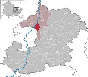
| Location of the community of Golmsdorf in the Saale-Holzland district | ||
  |
||

Golmsdorf is a municipality in the north of the Saale-Holzland district in Thuringia and part of the Dornburg-Camburg administrative community . The community is divided into the districts of Golmsdorf, Beutnitz and Naura .

geography
Geographical location
The community of Golmsdorf is located at the exit of the Gleistal , 2 km east of the B 88 in the Saale valley between Jena and Dornburg . The country road 2307 runs through Golmsdorf. The city of Jena is approx. 7 km away and the next motorway is the A 4 11 km south. The next train station is in Porstendorf, 2 km west of the Saalbahn between Großheringen and Saalfeld . The Crossen – Porstendorf railway line existed until 1969 , with a stop in Golmsdorf.
Neighboring communities are (clockwise) Neuengönna in the west, Dorndorf-Steudnitz in the north, Tautenburg in the northeast, Löberschütz and Jenalöbnitz in the east and the independent city of Jena in the southwest.
landscape
The municipality is shaped by the landscape of the middle Saale valley. At Golmsdorf the Gleistal opens wide to the Saale valley and not far from the village the tracks join the Saale . There are fields or meadows in the Saale floodplain and the river is lined with trees. The Saale divides west of Golmsdorf and forms the Raven Island .

The eastern part of the municipality lies in the area of the Gleistal and the adjacent heights. From the Tautenburger Forst in the north and from the Großer Gleisberg in the south the slopes fall, only steeper in the area of the shell limestone, and flatter and hilly in the lower area in the red sandstone. In the past, there were important vineyards on the south to south-west facing slopes, which have been replaced in the course of modern times by orchards that are still partially preserved. A number of old vineyard houses have survived. The remaining areas of the Gleistal are now used as fields or meadows. The wooded plateaus in the north and south reach heights of up to 337 and 345 m above sea level. NN . The Gleistal continues to the east to Bürgel .
history
Finds from excavations carried out in 2011 as part of the development of building land on the parcel “In den Hofäckern” point to an as yet unknown prehistoric settlement. Even then, the Gleisetal was a trade route from west to east via the Saalefurt “Hummelstedt” and Gleisefurt “Quere” near Bürgel and also northwards via the Tautenburger Forst. The Gleisetal was already a popular settlement area back then.
Golmsdorf was first mentioned in 1249 in connection with the Gleisberg rule. The same document also mentions a pastor in the village for the first time, which indicates that there was a church in the village even then. The place name is derived from the Slavic personal name Golem. The noble family of the Lords of Gleisberg was enfeoffed with the same rule in the first half of the 12th century. A short time later this family died out, and the completed fiefdom was taken over by Reichsministerials, the so-called Vögten von Gleisberg, who were able to maintain it until the 14th century. Followed by the bailiffs of Plauen, the rule briefly passed into the possession of the taverns of Dornburg around 1345, before it came into the possession of the Wettins, who incorporated the rule into the Wettin system of offices. The oldest surviving official account of the nursing from 1389 testifies to this.
Around 1533 the Lords of Lichtenhain , who had had their headquarters in Schöngleina since 1501 , owned a manor in Golmsdorf. After the death of the last owner, Georg Friedrich von Lichtenhain, who died on December 28, 1655 in Gleina, the estate fell back to Duke Wilhelm von Sachsen-Jena , who sold it to residents of Golmsdorf and Beutnitz, who paid the purchase price of 7,600 Mfsn . (Saxon guilders) had to pay the duke's debtor, the Privy Councilor Veit Ludwig von Seckendorff , within six years .
In 1835 there were 80 houses with 366 inhabitants. The corridor was 1,550 acres in size. The Gleisberg Castle was also located in this area. The viticulture of the Gleistal brought the villages here a certain prosperity since the Middle Ages. More precise data on the history of the place can be found in the local history.
Culture and sights
The Bornfege Festival in Golmsdorf and Beutnitz has had a long tradition. On this occasion, Johann Wolfgang von Goethe is said to have come here in 1799. The ruins of Kunitzburg , also known as Gleisburg, are located on the Großer Gleisberg . A cycle path now runs along the former Crossen – Porstendorf railway line .
Web links
- gemeinde-golmsdorf.de - Website of the community Golmsdorf
- jenzigverlag.de - Local regional publisher
- thueringenfotos.de - Photos from the village from 1988
Individual evidence
- ^ Population of the municipalities from the Thuringian State Office for Statistics ( help on this ).
- ↑ Angelika Schimmel: Surprise under the sward - archaeologists dig in Golmsdorf - evidence of a prehistoric settlement. In: Ostthüringer Zeitung , April 23, 2011.
- ↑ Kurt Zahn: The pastors of the superintendent Jena. From the beginning to the end of the 18th century (= AMF series of publications. 68, ZDB -ID 2380765-9 ). 6th, revised and expanded edition - 2nd reprint of the revised and significantly expanded edition. Working Group for Central German Family Research, Kleve 2006.
- ↑ Detlef Ignasiak: On the Saale and in the woodland. A cultural and historical guide through the area around the university town of Jena. quartus-Verlag, Jena 1997, ISBN 3-931505-17-0 .
- ^ Ernst Devrient : Gleissberg. History of the castle and the lords of Gleißberg near Jena. In: Journal of the Association for Thuringian History and Archeology. Vol. 20 = NF Vol. 12, Issue 1, 1900, pp. 1-53 .
- ↑ a b Jonathan C. Zenker : Historical-topographical pocket book of Jena and its surroundings, especially in natural science and medical relationship. Frommann, Jena 1836, pp. 116-117 .
- ↑ History database Middle Saale Valley [[email protected]]
Albersdorf | Altenberga | Bad Klosterlausnitz | Bibra | Bobeck | Bremsnitz | Bucha | Bürgel | Crossing the Elster | Dornburg-Camburg | Eichenberg | Eineborn | Eisenberg | Frauenprießnitz | Outdoor orla | Geisenhain | Gneus | Golmsdorf | Gosen | Graitschen at Bürgel | Greater buckedra | Grosseutersdorf | Großlöbichau | Großpürschütz | Gumperda | Hainichen | Hainspitz | Hartmannsdorf | Heathland | Hermsdorf | Hummelshain | Jenalöbnitz | Kahla | Karlsdorf | Little buckedra | Kleinebersdorf | Kleineutersdorf | Laasdorf | Lehesten | Lindig | Lippersdorf-Erdmannsdorf | Löberschütz | Mertendorf | Meusebach | Milda | Möckern | Mörsdorf | Nausnitz | Neuengönna | Oberbodnitz | Orlamünde | Ottendorf | Petersberg | Poxdorf | Rattelsdorf | Rauda | Rauschwitz | Rausdorf | Reichenbach | Reinstädt | Renthendorf | Rothenstein | Ruttersdorf-Lotschen | Scheiditz | Schkölen | Grinding trips | Schlöben | Schöngleina | Schöps | Side rod | Serba | Silbitz | Stadtroda | St. Gangloff | Sulza | Tautenburg | Tautendorf | Tautenhain | Animal snail | Tissa | Trobnitz | Trockenborn-Wolfersdorf | Unterbodnitz | Waldeck | Walpernhain | Waltersdorf | Weissbach | Weißenborn | Wichmar | Rooms | Zollnitz