Rutha (Sulza)
|
Rutha
Sulza municipality
|
||
|---|---|---|
| Coordinates: 50 ° 52 ′ 29 ″ N , 11 ° 37 ′ 13 ″ E | ||
| Height : | 157 m above sea level NN | |
| Area : | 3.96 km² | |
| Incorporation : | July 1, 1950 | |
| Postal code : | 07751 | |
| Area code : | 03641 | |
|
Location of Rutha in Thuringia |
||
|
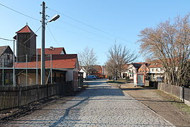
The center of Rutha
|
||
Rutha is a district of Sulza in the Saale-Holzland district in Thuringia .
location
Rutha located north of Sulza and borders north to the industrial park Stadtrodaer road from Jena . The Roda flows south of the place over to the Saale valley and flows into the Saale. The Weimar – Gera railway line runs to the north, followed by federal motorway 4 . This means that the district is very well connected in terms of transport.
history
The village was first mentioned in documents in 1349/50. In 1842 the Rutha village church was built on a new site on the mountain. The old church near the stream has been converted into a residential building. You can still see 2 arched windows on the north side of house no.21. The oldest register of the inhabitants comes from the first half of the 15th century.
Since its incorporation into the Wettin state, the place belonged to the manor Drackendorf within the administrative district of Burgau, later the district of Jena, until 1920. With the formation of the state of Thuringia, it came to the district of Jena-Stadtroda.
On July 1, 1950, Rutha was incorporated into Sulza.
Personalities
- Robert Burkhardt (1874–1954), German homeland researcher
Web links
Individual evidence
- ↑ Woldemar Lippert , Hans Beschorner : The Lehnbuch Friedrichs des Strengen, Margrave of Meissen and Landgrave of Thuringia 1349-1350. Leipzig 1903.
- ^ Landesarchiv Thuringia , Main State Archive Weimar , Ernestine General Archive Reg. Bb 710; Edited by Andrei Zahn: The residents of the offices of Burgau, Camburg and Dornburg. A prayer register from around 1421 - 1425 (= series of publications by the Working Group for Central German Family Research , No. 55). Mannheim 1998.


