Taupadel (Nobitz)
|
Taupadel
community Nobitz
Coordinates: 50 ° 53 ′ 37 ″ N , 12 ° 24 ′ 8 ″ E
|
|
|---|---|
| Height : | 256 (249–268) m above sea level NHN |
| Area : | 3.24 km² |
| Residents : | 198 |
| Population density : | 61 inhabitants / km² |
| Incorporation : | January 1, 1996 |
| Incorporated into: | Saara |
| Postal code : | 04603 |
| Area code : | 034493 |
|
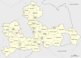
Location of Taupadel in the unified municipality of Nobitz
|
|
|
In the local situation
|
|
Taupadel is a district of the East Thuringian municipality of Nobitz in the Altenburger Land district , three kilometers east of Schmölln .
geography
Taupadel is located in the south of the Altenburger Land . The place is the southwestern part of the municipality Nobitz. In addition to the town of Schmölln itself, the neighboring districts are Nitzschka , Großstöbnitz and Kleinmückern as well as Bornshain as the only neighboring district of the municipality and Nörditz as the district of Gößnitz .
history
The place is mentioned for the first time in 1336 as Tupadel . Once a dead end village , it can now be identified as a street village and can probably be traced back to a German foundation. The place was subject to interest for the manor houses of Maltis , Löhmigen and Zürchau and was probably never such a seat itself. Taupadel belonged to the Wettin office of Altenburg , which was under the sovereignty of the following Ernestine duchies from the 16th century due to several divisions in the course of its existence : Duchy of Saxony (1554 to 1572), Duchy of Saxony-Weimar (1572 to 1603), Duchy of Saxony-Altenburg (1603 to 1672), Duchy of Saxony-Gotha-Altenburg (1672 to 1826). When the Ernestine duchies were reorganized in 1826, the place came back to the duchy of Saxony-Altenburg. After the administrative reform in the duchy, it belonged to the Eastern District (until 1900) and to the Ronneburg District Office (from 1900). From 1918 the village belonged to the Free State of Saxony-Altenburg , which was added to the State of Thuringia in 1920. In 1922 it came to the district of Altenburg . In the past centuries, the majority of the four-sided farms in the village often burned down, five of them in 1641 at the time of the Thirty Years War by Swedish soldiers. Then in 1781 seven farms burned down. In 1906 there was a fire in a barn and a cowshed building. However, a volunteer fire brigade was only founded in 1934. As early as 1907 Taupadel got a telephone connection and 20 years later electric street lighting. A steam dairy existed in Taupadel, which was founded on January 14th, 1905 and started work on October 16th of the same year. A cheese dairy was built in 1934. However, a large dairy was built in Meerane just five years later and the one located here was closed. From the time LPG Vorwärts was founded in 1952, its office was set up in this building .
During the second district reform in the GDR in 1952, the existing states were dissolved and the districts were redesigned. Thus Taupadel came with the county Schmölln to the district of Leipzig , since 1990 as a county belonged to Schmölln Thuringia and opened in 1994 Altenburger in the district of the country. On August 25, 1961, Bornshain was incorporated into Taupadel. On March 8, 1994, the Taupadel community joined the Saara community . This was dissolved on January 1st, 1996 and transferred to the community of Saara, except for the community of Großstöbnitz . On the day before it was incorporated on December 31, 1995, the municipality had 382 inhabitants, 14 fewer than a year earlier. With the incorporation of Saara on December 31, 2012, Taupadel came to the municipality of Nobitz.
Population development
- 1583-100
- 1847-172
- 1910-218
- 1933-228
- 1948-385
- 1981-220
- 2013 - 198
Attractions
To the south of the village is a pond that has been renatured in recent years. In 1872 seven linden trees were planted on this, commemorating all seven combatants in the Franco-Prussian War of 1871 , who returned unscathed. There is also a country inn with a dance hall, in which various events take place, such as a senior dance meeting once a month.
The Klinge forest is also to the north in the direction of Kleinmückern . Due to its scenic location, this is a narrowly defined area that has not been developed for centuries. Steep and poorly manageable slopes made it possible for a small Central European "primeval forest" to develop here. In the vicinity there is a small pond, which is the first source of the stream that rises on the watershed between Sprotte and Pleiße and flows into the Sprotte. In the 1960s, however, the first 500 meters were piped.
Web links
Individual evidence
- ^ The Altenburg Office in the book "Geography for all Stands", from p. 201
- ^ The locations of the Altenburg district from p.83
- ↑ The eastern district of the Duchy of Saxony-Altenburg in the municipal directory 1900
- ^ The district office of Ronneburg in the municipality register 1900
- ^ Bornshain on gov.genealogy.net
- ^ Parish: Taupadel. Thuringian State Office for Statistics, accessed on August 3, 2017 .
- ↑ Municipal directory 1910
- ^ Michael Rademacher: German administrative history from the unification of the empire in 1871 to reunification in 1990. City and district of Altenburg. (Online material for the dissertation, Osnabrück 2006).
- ^ Taupadel on the parish side

