Klausa (Nobitz)
|
Klausa
community Nobitz
Coordinates: 50 ° 57 ′ 29 ″ N , 12 ° 30 ′ 43 ″ E
|
|
|---|---|
| Height : | 221 (202-233) m above sea level NHN |
| Incorporation : | 1st January 1973 |
| Postal code : | 04603 |
| Primaries : | 03447, 034494 |
|
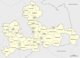
Location of Klausa in Nobitz
|
|
|
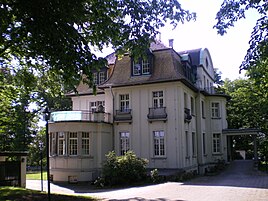
Factory owner's villa
|
|
Klausa is a district of Nobitz in the Altenburger Land district in Thuringia .
Location and traffic
Klausa is located south of Nobitz and north of Ehrenhain on federal highway 180 . The village is located on the Leinawald 8 kilometers east of Altenburg . Between 1901 and 1995 Klausa had a breakpoint on the Altenburg – Langenleuba-Oberhain railway line .
history
The place was first mentioned in a document in 1590. At the edge of the forest, a small settlement for forest workers from the state forest was built at a customs post. The hallway was included in the neighboring Garbus . The place belonged to the Wettin office of Altenburg , which was under the sovereignty of the following Ernestine duchies from the 16th century due to several divisions in the course of its existence : Duchy of Saxony (1554 to 1572), Duchy of Saxony-Weimar (1572 to 1603), Duchy of Saxony- Altenburg (1603 to 1672), Duchy of Saxe-Gotha-Altenburg (1672 to 1826). When the Ernestine duchies were reorganized in 1826, the place came back to the duchy of Saxony-Altenburg. After the administrative reform in the duchy, it belonged to the eastern district (until 1900) and to the Altenburg district office (from 1900). From 1918 the village belonged to the Free State of Saxony-Altenburg , which was added to the State of Thuringia in 1920. In 1922 it came to the district of Altenburg .
In the late 19th century, the Winterfeld lignite mine and a small briquette factory opened in the neighboring town of Garbus , offering year-round work opportunities. Industrialization resulted in the steady growth of the place. In 1901 the construction of the Altenburg – Langenleuba-Oberhain railway was completed. On the way to Hauersdorf , the Klausa stop was built to load the goods produced in the Altenburg area (brickwork products, wood from the flax forest and lignite briquettes). Several manufacturers' villas and country houses were built in the wooded area. Some houses were expropriated after the Second World War and used as a retirement home from 1959. The building was modernized from 1996 to 1998.
On March 1, 1951, the Garbus community was renamed Klausa . Since January 1, 1973 Klausa has been part of Nobitz together with the neighboring town of Garbus. During the second district reform in the GDR in 1952, the existing states were dissolved and the districts were redesigned. Thus the place came with the district Altenburg at the Leipzig district , since 1990 as a county belonged to Altenburg Thuringia and opened in 1994 Altenburger in the district of the country. The train stop went out of service in 1995.
Leinawald
The neighboring Leinawald is important for local history. The entire forest was measured in the middle of the 19th century on behalf of the ducal forest administration in 100 square plots, each 333 m long and divided by precisely measured aisles, parallel to the approximately 4 km long "Klausalinie" (main axis of the measurement). The resulting quadrants corresponded to the management method for state forests developed in the 19th century.
Military area and airfield
The Nobitz parade ground, which was laid out on the northwestern edge of the Leinawald before the First World War , was also used by the imperial air force as a " Nobitz flying station ". During the war, a military replacement pilot unit was relocated to Nobitz. An area of 110 hectares that had been confiscated on the edge of the Leinawald was cleared and leveled, and barracks and airport hangars were built. An approximately 3-kilometer-long track was laid from the Klausa stop to the airfield. In the 1930s, a military airfield and barracks for training were built on the site. During the Second World War, the airfield served as a base for the German Air Force . On April 14, 1945, American combat units captured the airfield and the military facilities and depots in the Leinawald. On July 1, 1945, the Red Army occupied the airfield and used it until 1992.
Web links
Individual evidence
- ^ Wolfgang Kahl : First mention of Thuringian towns and villages. A manual. Rockstuhl Verlag, Bad Langensalza, 2010, ISBN 978-3-86777-202-0 , p. 143.
- ^ The Altenburg Office in the book "Geography for all Stands", from p. 201
- ^ The locations of the Altenburg district from p.83
- ↑ The eastern district of the Duchy of Saxony-Altenburg in the municipal directory 1900
- ^ The Altenburg district office in the municipality register 1900
- ↑ Klausa on the website of the municipality of Nobitz.Retrieved on January 21, 2016.
- ↑ Federal Statistical Office (Ed.): Municipalities 1994 and their changes since 01.01.1948 in the new federal states . Metzler-Poeschel, Stuttgart 1995, ISBN 3-8246-0321-7 .
- ↑ Garbus and Klausa on gov.genealogy.net
- ↑ Stefan Büttner: Red places - Russian military airfields Germany 1945–1994 , AeroLit, Berlin, 2007, ISBN 978-3-935525-11-4 , p. 183.


