Wolperndorf
|
Wolperndorf
community Nobitz
Coordinates: 50 ° 54 ′ 48 ″ N , 12 ° 38 ′ 0 ″ E
|
|
|---|---|
| Height : | 249 m above sea level NN |
| Incorporation : | 1st January 1973 |
| Incorporated into: | Jückelberg |
| Postal code : | 04603 |
| Area code : | 034497 |
|
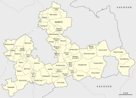
Location of Wolpernsdorf in the unified municipality of Nobitz
|
|
|
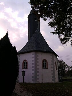
St. Walburga Church
|
|
Wolperndorf is a district of Nobitz in the Altenburger Land district in Thuringia .
geography
Location and traffic
The Waldhufendorf Wolperndorf is located in the Osterland . It is the easternmost place in Thuringia. The corridors are located in the Altenburger loess hill country , which is ending. The district lies in the northeast on a sandstone ridge , which is known as the Heidelberger . The district boundaries to the east form the border with Saxony . The county road 301 passes close by. The federal highway 175 also, but there is no direct connection to it via an asphalt road. The stream flowing through the village drains into the Zwickauer Mulde , so the place, unlike most places in the district, does not belong to the catchment area of the Pleiße .
Neighboring places
| Garbisdorf | Jückelberg | |
| Goepfersdorf |

|
|
| Francs | Punch joke | Wolkenburg-Kaufungen |
history
In 1336 Wolperndorf was mentioned in a document. The “ St. Walburga ” church in Wolperndorf was built in 1580 in the late Gothic style.
Wolperndorf belonged to the Wettin office of Altenburg , which was under the sovereignty of the following Ernestine duchies from the 16th century due to several divisions in the course of its existence : Duchy of Saxony (1554 to 1572), Duchy of Saxony-Weimar (1572 to 1603), Duchy of Saxony-Altenburg (1603 to 1672), Duchy of Saxony-Gotha-Altenburg (1672 to 1826). When the Ernestine duchies were reorganized in 1826, the place came back to the duchy of Saxony-Altenburg. After the administrative reform in the duchy, it belonged to the eastern district (until 1900) and to the Altenburg district office (from 1900). From 1918 the village belonged to the Free State of Saxony-Altenburg , which was added to the State of Thuringia in 1920. In 1922 it came to the district of Altenburg .
During the second district reform in the GDR in 1952, the existing states were dissolved and the districts were redesigned. Thus Wolperndorf came with the district Altenburg at the Leipzig district , since 1990 as a district Altenburg belonged to Thuringia and opened in 1994 Altenburger in the district of the country.
On January 1, 1973, the communities of Flemmingen and Wolperndorf were merged into a new community. This was named Jückelberg . The community center was in Flemmingen.
On July 6, 2018, Jückelberg was incorporated into Nobitz.
The location Wolperndorf was placed under monument protection. In addition to the church, this also includes numerous historic four-sided courtyards and half-timbered houses . A farmer is currently using some half-timbered buildings for horse breeding and as a holiday farm with holiday apartments.
Individual evidence
- ^ Wolfgang Kahl: First mention of Thuringian towns and villages. A manual. Rockstuhl Verlag, Bad Langensalza, 2010, ISBN 978-3-86777-202-0 , p. 320
- ↑ Wolperndorf Church on the website of the Verwaltungsgemeinschaft Wieratal. Accessed on July 22, 2012
- ^ The Altenburg Office in the book "Geography for all Stands", from p. 201
- ^ The locations of the Altenburg district from p.83
- ↑ The eastern district of the Duchy of Saxony-Altenburg in the municipal directory 1900
- ^ The Altenburg district office in the municipality register 1900
- ↑ Federal Statistical Office (Ed.): Municipalities 1994 and their changes since 01.01.1948 in the new federal states . Metzler-Poeschel, Stuttgart 1995, ISBN 3-8246-0321-7 , pp. 459 .
- ↑ Thuringian Law and Ordinance Gazette No. 7 2018 of July 5, 2018 , accessed on July 6, 2018
Web links

