Hauersdorf (Nobitz)
|
Hauersdorf
community Nobitz
Coordinates: 50 ° 57 ′ 20 ″ N , 12 ° 29 ′ 47 ″ E
|
|
|---|---|
| Height : | 230 m above sea level NN |
| Residents : | 41 (2012) |
| Incorporation : | July 1, 1950 |
| Incorporated into: | Oberleupten |
| Postal code : | 04603 |
| Area code : | 034494 |
|
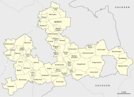
Location of Hauersdorf in Nobitz
|
|
|
View of the place
|
|
Hauersdorf is a hamlet-like district of Nobitz in the Altenburger Land district in Thuringia .
location
The place is three kilometers (as the crow flies) south of the capital Nobitz and seven kilometers southeast of the district town of Altenburg in the Loess Hills around Altenburg on the edge of the Leipzig lowland bay . The geographic height of the place is 230 m above sea level. NN .
history
Hauersdorf was first mentioned in a document between 1181 and 1214 as "Hugoldesdorf". In 1445 there were six farms, in 1880 13 houses were counted in the village. The parish corridor is only 65 hectares.
Hauersdorf belonged to the Wettin office of Altenburg , which from the 16th century was under the sovereignty of the following Ernestine duchies due to several divisions during its existence : Duchy of Saxony (1554 to 1572), Duchy of Saxony-Weimar (1572 to 1603), Duchy of Saxony-Altenburg (1603 to 1672), Duchy of Saxony-Gotha-Altenburg (1672 to 1826). When the Ernestine duchies were reorganized in 1826, the place came back to the duchy of Saxony-Altenburg. After the administrative reform in the duchy, it belonged to the eastern district (until 1900) and to the Altenburg district office (from 1900). From 1918 the village belonged to the Free State of Saxony-Altenburg , which was added to the State of Thuringia in 1920. In 1922 it came to the district of Altenburg .
Hauersdorf was incorporated into Oberleupten on July 1, 1950 , which in turn was incorporated into the municipality of Nobitz on January 1, 1973. During the second district reform in the GDR in 1952, the existing states were dissolved and the districts were redesigned. Thus Hauersdorf came with the district Altenburg at the Leipzig district , since 1990 as a county belonged to Altenburg Thuringia and opened in 1994 Altenburger in the district of the country.
Between 1901 and 1995 there was a "Klausa halt" on the Altenburg – Langenleuba-Oberhain railway line on the route to the neighboring village of Klausa , which served as a loading station for the briquette factory built in the neighboring village of Garbus and the Winterfeld lignite mine. After 1952 this area was managed by an LPG , then it fell to VEG Priefel. Today the areas are privately cultivated again.
Web links
Individual evidence
- ↑ Official topographic maps of Thuringia 1: 10,000. LK Altenburg, LK Greiz, district-free city of Gera . In: Thuringian Land Survey Office (Hrsg.): CD-ROM series Top10 . CD 5. Erfurt 1999.
- ^ Wolfgang Kahl : First mention of Thuringian towns and villages. A manual. Rockstuhl Verlag, Bad Langensalza, 2010, ISBN 978-3-86777-202-0 , p. 112
- ^ The Altenburg Office in the book "Geography for all Stands", from p. 201
- ^ The locations of the Altenburg district from p.83
- ↑ The eastern district of the Duchy of Saxony-Altenburg in the municipal directory 1900
- ^ The Altenburg district office in the municipality register 1900
- ↑ Hauersdorf on gov.genealogy.net
- ↑ Hauersdorf on the website of the municipality of Nobitz.Retrieved on January 21, 2016

