Oberleupten
|
Oberleupten
community Nobitz
Coordinates: 50 ° 57 ′ 43 ″ N , 12 ° 29 ′ 8 ″ E
|
|
|---|---|
| Height : | 211 m above sea level NHN |
| Residents : | 71 (Jun 21, 2010) |
| Incorporation : | 1st January 1973 |
| Postal code : | 04603 |
| Area code : | 03447 |
|
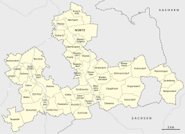
Location of Oberleupten in Nobitz
|
|
Oberleupten is a district of Nobitz in the Thuringian district of Altenburger Land, about 5 km south of the Skat and residence town of Altenburg .
geography
Adjacent places are Kotteritz , starting clockwise from the northwest, Nobitz, Niederleupten , Klausa , Hauersdorf and Priefel as districts of the municipality of Nobitz, and to the west the district of Ehrenberg of the city of Altenburg with the locality of Stünzhain .
history
Around 1200 the village was referred to as "in alio Lipen", until 1445 the old Sorbian name "Lipan" had become naturalized, which means something like those who live on the linden tree . At that time the place had ten occupied courtyards, today seven still exist. The fief of the burgraves of Altenburg located in the village was assigned to the miners' monastery in Altenburg at the beginning of the 14th century .
Later the place belonged to the Wettin office of Altenburg , which from the 16th century was under the sovereignty of the following Ernestine duchies due to several divisions in the course of its existence : Duchy of Saxony (1554 to 1572), Duchy of Saxony-Weimar (1572 to 1603), Duchy of Saxony -Altenburg (1603 to 1672), Duchy of Saxony-Gotha-Altenburg (1672 to 1826). When the Ernestine duchies were reorganized in 1826, the place again became part of the Duchy of Saxony-Altenburg.
After the administrative reform in the duchy, Oberleupten belonged to the eastern district (until 1900) and to the Altenburg district office (from 1900). From 1918 the village belonged to the Free State of Saxony-Altenburg , which was added to the State of Thuringia in 1920.
On July 1, 1950, the previously independent communities of Dippelsdorf , Hauersdorf and Priefel were incorporated. During the second district reform in the GDR in 1952, the existing states were dissolved and the districts were redesigned. Thus the place came with the reduced circle Altenburg to the district of Leipzig .
On January 1, 1973 Dippelsdorf was reclassified to the community of Ehrenhain . The core town of Oberleupten came together with the towns of Priefel and Hauersdorf to the municipality of Nobitz. In 1990 Oberleupten came to Thuringia as a district of Nobitz with the district of Altenburg, which became part of the district of Altenburger Land in 1994.
Originally the place was a dead end village. In the center of the village, in the immediate vicinity of the extinguishing water pond, is the community well from 1813, which was damaged and therefore redesigned. It is now made of Rochlitz porphyry . Around the pond are several Vierseithof in framework construction .
traffic
The closest junction to the A4 is Glauchau-Ost and is around 15 km away. The federal highway 180 runs 1 km east of the village. Leipzig-Altenburg Airport is located about 2 km northeast of Oberleupten .
Web links
Individual evidence
- ^ History of the Burgraves of Altenburg, p. 58
- ^ The Altenburg Office in the book "Geography for all Stands", from p. 201
- ^ The locations of the Altenburg district from p.83
- ↑ The eastern district of the Duchy of Saxony-Altenburg in the municipal directory 1900
- ^ The Altenburg district office in the municipality register 1900


