Jückelberg
|
Jückelberg
community Nobitz
Coordinates: 50 ° 55 ′ 35 ″ N , 12 ° 37 ′ 44 ″ E
|
|
|---|---|
| Height : | 248 m |
| Area : | 7.9 km² |
| Residents : | 289 (December 31, 2016) |
| Population density : | 37 inhabitants / km² |
| Incorporation : | 6th July 2018 |
| Postal code : | 04603 |
| Area code : | 034497 |
|
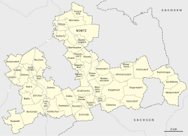
Location of Jückelberg in the unified municipality of Nobitz
|
|
Jückelberg is a part of the municipality Nobitz in the Thuringian district of Altenburger Land . It is the easternmost place in the state.
geography
Jückelberg is located in Osterland and was the easternmost municipality in Thuringia until it was incorporated into Nobitz in 2018. In the northeast of the village there is a sandstone ridge, the so-called Heidelberger .
Former local division
The districts of Jückelberg, Flemmingen and Wolperndorf belonged to the community of Jückelberg .
Neighboring places
Adjacent places are (clockwise) the city of Penig with the district Niedersteinbach in the Saxon district of central Saxony , the city of Limbach-Oberfrohna with the district of Wolkenburg-Kaufungen in the district of Zwickau , which also belongs to Saxony , the city of Waldenburg with the district of Dürrenuhlsdorf in the district of Zwickau and Göpfersdorf including the Garbisdorf district , the municipality of Nobitz with the Frohnsdorf district and Langenleuba-Niederhain with the Beiern district in the Altenburger Land district.
history
Jückelberg was first mentioned in a tax register in 1280. In 1866 a medieval stone cross was discovered which, according to a legend, was erected there because a carpenter and a butcher killed themselves there.
Jückelberg belonged to the Wettin office of Altenburg , which from the 16th century onwards was under the sovereignty of the following Ernestine duchies due to several divisions during its existence : Duchy of Saxony (1554 to 1572), Duchy of Saxony-Weimar (1572 to 1603), Duchy of Saxony-Altenburg (1603 to 1672), Duchy of Saxony-Gotha-Altenburg (1672 to 1826). When the Ernestine duchies were reorganized in 1826, the place came back to the duchy of Saxony-Altenburg. After the administrative reform in the duchy, it belonged to the eastern district (until 1900) and to the Altenburg district office (from 1900). From 1918 the village belonged to the Free State of Saxony-Altenburg , which was added to the State of Thuringia in 1920. In 1922 it came to the district of Altenburg .
During the second district reform in the GDR in 1952, the existing states were dissolved and the districts were redesigned. Thus, the village Jückelberg came with the district Altenburg at the Leipzig district , since 1990 as a district Altenburg belonged to Thuringia and opened in 1994 Altenburger in the district of the country. On January 1, 1973, the communities of Flemmingen and Wolperndorf were merged into a new community. This was named Jückelberg. The community center was in Flemmingen.
On July 6, 2018, Jückelberg was incorporated into the Nobitz community.
Population development
Development of the population (as of December 31st) :
|
|
|
|
- Data source: Thuringian State Office for Statistics
politics
mayor
Mayor was Bernd Graefe from 1994 to 1999. From then until 2016 Jörg Steinmetz accompanied this office. On June 5, 2016, Jürgen Haupt was elected as mayor with a majority of 98.3% unopposed candidates and a turnout of 48.2% (+ 2.7% p).
Municipal council
Since the local elections on May 25, 2014 , the local council has been composed as follows:
- CDU - 4 seats (73.6%)
- Fire Brigade Association Wolperndorf - 2 seats (26.4%)
The turnout was 55.0%.
Attractions
- The district Wolperndorf is under monument protection, so there are numerous historical four-sided courtyards and half-timbered houses in the place. The forest hoof village is first mentioned in a document in 1336. The church in the center of the village was built in 1580 in the late Gothic style.
- There is also a late Gothic church in the Flemmingen district, but it was built in 1490. The Romanesque choir still preserved today dates from 1252.
See also: List of churches in Altenburger Land
Individual evidence
- ↑ Steinkreuz on suehnekreuz.de
- ^ The Altenburg Office in the book "Geography for all Stands", from p. 201
- ^ The locations of the Altenburg district from p.83
- ↑ The eastern district of the Duchy of Saxony-Altenburg in the municipal directory 1900
- ^ The Altenburg district office in the municipality register 1900
- ↑ Federal Statistical Office (Ed.): Municipalities 1994 and their changes since 01.01.1948 in the new federal states . Metzler-Poeschel, Stuttgart 1995, ISBN 3-8246-0321-7 , pp. 459 .
- ↑ Thuringian Law and Ordinance Gazette No. 7 2018 of July 5, 2018 , accessed on July 6, 2018
- ↑ Results of the mayoral election on the website of the Regional Returning Officer Thuringia , accessed on July 31, 2016

