Gleina (Nobitz)
|
Gleina
community Nobitz
Coordinates: 50 ° 56 ′ 14 " N , 12 ° 23 ′ 35" E
|
|
|---|---|
| Height : | 233 m above sea level NN |
| Residents : | 86 |
| Incorporation : | July 1, 1950 |
| Incorporated into: | Burkersdorf b. Lehndorf |
| Postal code : | 04603 |
| Area code : | 03447 |
|
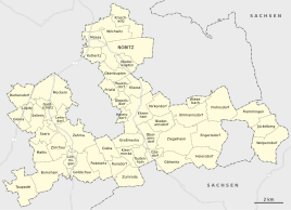
Location of Gleina in the unified municipality of Nobitz
|
|
|
View of the AbgTZg 355 on the watch pole
|
|
Gleina is a district of the municipality Nobitz in the Altenburger Land district in Thuringia .
location
Gleina is located six kilometers south of the city of Altenburg in the arable farming area of the Altenburger-Schmöllner loess hill country and to the right of the blue tide . The village is on federal highway 7 .
history
The village was first mentioned in a document on March 22, 1286. It emerged from a Sorbian settlement. Glina means in the Sorbian language = clay .
Gleina belonged to the Wettin office of Altenburg , which was under the sovereignty of the following Ernestine duchies from the 16th century onwards due to several divisions during its existence : Duchy of Saxony (1554 to 1572), Duchy of Saxony-Weimar (1572 to 1603), Duchy of Saxony-Altenburg (1603 to 1672), Duchy of Saxony-Gotha-Altenburg (1672 to 1826). When the Ernestine duchies were reorganized in 1826, the place came back to the duchy of Saxony-Altenburg. After the administrative reform in the duchy, it belonged to the eastern district (until 1900) and to the Altenburg district office (from 1900). From 1918 the village belonged to the Free State of Saxony-Altenburg , which was added to the State of Thuringia in 1920. In 1922 it came to the district of Altenburg .
Gleina was moved to Burkersdorf b. Lehndorf incorporated. During the second district reform in the GDR in 1952, the existing states were dissolved and the districts were redesigned. Thus Gleina came as the district of Burkersdorf with the district Altenburg at the Leipzig district , since 1990 as a county belonged to Altenburg Thuringia and opened in 1994 Altenburger in the district of the country. By incorporating the municipality of Burkersdorf and its districts, Gleina came to the municipality of Lehndorf on January 1, 1973 . With the rise of the community Lehndorf in the unified community Saara , Gleina became a district of this community on January 1, 1996, until it came to Nobitz on December 31, 2012. Today there is a country hotel on a farm in Gleina .
Radar station
The manor Schellenberg was taken over by the NVA in 1960 . Three apartment blocks were added for the soldiers and their families. A radio measuring post with radar was set up in 1961 on the opposite, highest elevation in the Altenburg area, the Wachtstange , on which a flak position was already set up in World War II . This later became the Radio Technology Company (FuTK) 312 of the NVA - LSK / LV .
This was taken over by the German Armed Forces on October 3, 1990 and continued to operate from a NATO perspective. The radar tower , which can be seen from afar, was built with the RRP 117 in 1994/95 . This then went into operation in 1996, the old Russian radio measuring stations ( P-37 and PRW-13 ) were scrapped. In 1995, the unit was reorganized and reorganized as the Separated Technical Train (AbgTZg) 254 . On October 1, 2002, the train was renamed AbgTZg 355 . The train is subordinate to operational control area 3 .
Web links
Individual evidence
- ^ Wolfgang Kahl : First mention of Thuringian towns and villages. A manual. Verlag Rockstuhl, Bad Langensalza 2010, ISBN 978-3-86777-202-0 , p. 91
- ^ The Altenburg Office in the book "Geography for all Stands", from p. 201
- ^ The locations of the Altenburg district from p.83
- ↑ The eastern district of the Duchy of Saxony-Altenburg in the municipal directory 1900
- ^ The Altenburg district office in the municipality register 1900
- ↑ Gleina on gov.genealogy.net
- ^ History of the Kerch court

