Kaimnitz
|
Kaimnitz
community Nobitz
Coordinates: 50 ° 57 ′ 9 ″ N , 12 ° 23 ′ 53 ″ E
|
|
|---|---|
| Height : | 215–228 m above sea level NN |
| Residents : | 5 (2012) |
| Postal code : | 04603 |
| Area code : | 03447 |
|
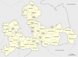
Location of Kaimnitz in the unified municipality of Nobitz
|
|
|
Village pond with a farmhouse built in 1820 (No. 2)
|
|
Kaimnitz is a part of the municipality Nobitz in the Altenburger Land district in Thuringia .
location
The agricultural hamlet is located on the right slope of the Blue Flood west of federal highway 7 and is surrounded by a high garden wall like a fortress. Kaimnitz is located about 5 km southwest of Altenburg . Adjacent places are next to the 500 m distant Burkersdorf , on whose district Kaimnitz lies, Kürbitz in the north as a district of Altenburg and Jauern in the west as a district of Schmölln .
history
The first documentary mention took place between 1181 and 1214 in the tithe register of the Bosau monastery . In 1580 33 people lived in the hamlet, 300 years later 41. Today, as already mentioned in 1732 and 1880, the place still consists of four properties. Around 1573 "Keymnitz with Burkersdorf" was still written. Later the place was included in Burkersdorf .
Kaimnitz belonged to the Wettin office of Altenburg , which was under the sovereignty of the following Ernestine duchies from the 16th century due to several divisions during its existence : Duchy of Saxony (1554 to 1572), Duchy of Saxony-Weimar (1572 to 1603), Duchy of Saxony-Altenburg (1603 to 1672), Duchy of Saxony-Gotha-Altenburg (1672 to 1826). When the Ernestine duchies were reorganized in 1826, the place came back to the duchy of Saxony-Altenburg. After the administrative reform in the duchy, it belonged to the eastern district (until 1900) and to the Altenburg district office (from 1900). From 1918 the village belonged to the Free State of Saxony-Altenburg , which was added to the State of Thuringia in 1920. In 1922 it came to the district of Altenburg .
During the second district reform in the GDR in 1952, the existing states were dissolved and the districts were redesigned. Thus Kaimnitz came as the district of Burkersdorf with the district Altenburg at the Leipzig district , since 1990 as a county belonged to Altenburg Thuringia and opened in 1994 Altenburger in the district of the country. By incorporating the municipality of Burkersdorf with its districts, Kaimnitz came to the municipality of Lehndorf on January 1, 1973 . With the rise of the community Lehndorf in the unified community Saara , Kaimnitz became a district of this community on January 1, 1996, until it came to Nobitz on December 31, 2012.
Townscape
The four-sided courtyard with house number 2, which was enlarged around 1820 and included in the list of monuments of the Altenburg district in 1980, today only consists of the house built in 1820. The cow and pigsty buildings built in 1824 and 1825 and the barn built in 1830 were demolished.
In the middle of the village there is a pond that was renatured in 1997.
In the course of history, the barn of the four-sided courtyard number 1 burned down three times, in the years 1838, 1882 and 2006.
Web links
Individual evidence
- ^ Wolfgang Kahl : First mention of Thuringian towns and villages. A manual. Rockstuhl Verlag, Bad Langensalza, 2010, ISBN 978-3-86777-202-0 , p. 136.
- ^ Kaimnitz on the website of the municipality of Nobitz.Retrieved on January 21, 2016.
- ^ The Altenburg Office in the book "Geography for all Stands", from p. 201
- ^ The locations of the Altenburg district from p.83
- ↑ The eastern district of the Duchy of Saxony-Altenburg in the municipal directory 1900
- ^ The Altenburg district office in the municipality register 1900

