Zehma
|
Zehma
community Nobitz
Coordinates: 50 ° 55 ′ 26 ″ N , 12 ° 26 ′ 40 ″ E
|
|
|---|---|
| Height : | 198 (194-215) m |
| Residents : | 250 |
| Incorporation : | January 1, 1996 |
| Incorporated into: | Saara |
| Postal code : | 04603 |
| Area code : | 034493 |
|
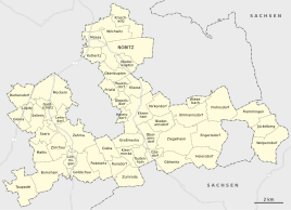
Location of Zehma in the unified municipality of Nobitz
|
|
|
Entrance
|
|
Zehma is a district of the East Thuringian municipality of Nobitz in Altenburger Land , eight kilometers south of the eponymous district town on the federal highway 93 .
geography
Zehma is located in the southern Altenburger Land, east of the Pleiße . Neighboring places are in the north, in addition to Friedrichslust , which belongs to the main town , Lehndorf , in the east the Altenburg districts of Greipzig and Mockzig and Gieba . In the south, close Podelwitz , Goldschau and Löhmigen and the West Zürchau . The highest point is the Lust or Friedrichslust on the Red Mountain with a height of 215 meters. The Zehma traffic jam connects to the south of the town .
history
Zemouua is first mentioned in 976 in a deed of gift from Emperor Otto II to the Zeitz diocese . This document mentions the donation of the city of Altenburg and some surrounding places in the Pleißengau to the Zeitz diocese. The place of Slavic origin was once a hamlet on an important road. From 1503 to 1528 there was a wooden chapel built by farmers in the place, which housed a carved image of St. Anne and thus established itself as a place of pilgrimage. The Reformation finally ended this cult.
Zehma belonged to the Wettin office of Altenburg , which was under the sovereignty of the following Ernestine duchies from the 16th century due to several divisions in the course of its existence : Duchy of Saxony (1554 to 1572), Duchy of Saxony-Weimar (1572 to 1603), Duchy of Saxony-Altenburg (1603 to 1672), Duchy of Saxony-Gotha-Altenburg (1672 to 1826). When the Ernestine duchies were reorganized in 1826, the place came back to the duchy of Saxony-Altenburg. After the administrative reform in the duchy, it belonged to the eastern district (until 1900) and to the Altenburg district office (from 1900). From 1918 the village belonged to the Free State of Saxony-Altenburg , which was added to the State of Thuringia in 1920. In 1922 it came to the district of Altenburg . In 1937 the local volunteer fire brigade was founded.
On July 1, 1950, Löhmigen was incorporated into Zehma. During the second district reform in the GDR in 1952, the existing states were dissolved and the districts were redesigned. Thus, the community came Zehma with the county Schmölln to the district of Leipzig , since 1990 as a county belonged to Schmölln Thuringia and opened in 1994 Altenburger in the district of the country. On November 1, 1973, the municipality of Zürchau with its district Maltis was incorporated into the municipality of Zehma.
On March 8, 1994, the municipality of Zehma joined the Saara administrative community . This was dissolved on January 1st, 1996 and transferred to the community of Saara , except for the community of Großstöbnitz . With the incorporation of Saara on December 31, 2012, Zehma came to the Nobitz community.
Friedrichslust hunting lodge
The Ducal Chamber Altenburg bought a 1,736 acre field for application of a lime-kiln. Duke Friedrich had a hunting lodge built on this piece of land, from which the name Friedrichslust derives. It was later used as an inn until 1945, today it is a residential building. The former pit area of the limestone quarry was designated as a natural monument, where limestone works and kilns were mentioned as early as 1682.
Attractions
A metal pony figure is located directly on Bundesstraße 93, which was erected in 1988 to commemorate equestrian sport.
Web links
Individual evidence
- ↑ a b Zehma on the website of the municipality of Nobitz (further information, especially on the horse history in the village). Accessed on January 21, 2016
- ^ Rudolf Hermann: An unknown place of pilgrimage (Zehma near Altenburg) . In: The Thuringian Flag . Monthly issues for the Central German homeland 3. 1934, p. 174–178 ( An unknown place of pilgrimage (Zehma near Altenburg) ( Memento from May 31, 2010 in the Internet Archive ) [accessed on August 3, 2017]).
- ^ The Altenburg Office in the book "Geography for all Stands", from p. 201
- ^ The locations of the Altenburg district from p.83
- ↑ The eastern district of the Duchy of Saxony-Altenburg in the municipal directory 1900
- ^ The Altenburg district office in the municipality register 1900
- ↑ Löhmigen on gov.genealogy.net
- ↑ Zurich on gov.genealogy.net


