Tautenhain (Nobitz)
|
Tautenhain
community Nobitz
Coordinates: 50 ° 54 ′ 48 " N , 12 ° 30 ′ 26" E
|
|
|---|---|
| Height : | 250–261 m above sea level NN |
| Residents : | 45 |
| Incorporation : | July 1, 1950 |
| Incorporated into: | Grand Mecka |
| Postal code : | 04603 |
| Area code : | 034494 |
|
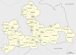
Location of Tautenhain in the unified municipality of Nobitz
|
|
|
View of the place from the east
|
|
Tautenhain is a hamlet-like district of the municipality of Nobitz in the Altenburger Land district in Thuringia .
location
Tautenhain is located southeast of Saara and southeast of the federal highway 180 . The Lunzigbach rises in the corridor of the village in the Altenburg-Zeitz loess hill country . In the south is the border with Saxony .
Adjacent places
Adjacent locations are Zumroda , starting clockwise in the southwest, Großmecka in the northwest , Ehrenhain in the north, Oberarnsdorf in the northeast and Gösdorf as districts of Nobitz in the east and Harthau as a district of the Saxon municipality of Oberwiera in the south .
history
Tautenhain was first mentioned in a document on September 26, 1318. Tautenhain belonged to the Wettin office of Altenburg , which was under the sovereignty of the following Ernestine duchies from the 16th century onwards due to several divisions during its existence : Duchy of Saxony (1554 to 1572), Duchy of Saxony-Weimar (1572 to 1603), Duchy of Saxony-Altenburg (1603 to 1672), Duchy of Saxony-Gotha-Altenburg (1672 to 1826). When the Ernestine duchies were reorganized in 1826, the place came back to the duchy of Saxony-Altenburg. After the administrative reform in the duchy, it belonged to the eastern district (until 1900) and to the Altenburg district office (from 1900). From 1918 the village belonged to the Free State of Saxony-Altenburg , which was added to the State of Thuringia in 1920. In 1922 it came to the district of Altenburg .
On July 1, 1950, Tautenhain was incorporated into Großmecka . During the second district reform in the GDR in 1952, the existing states were dissolved and the districts were redesigned. Thus Tautenhain came to the east of the circle Schmölln to the district of Leipzig , since 1990 as a county belonged to Schmölln Thuringia and opened in 1994 Altenburger in the district of the country. With the community Großmecka Tautenhain came on November 1, 1973 to the community Podelwitz . When the municipality Podelwitz became part of the unified municipality of Saara , Tautenhain became a district of this municipality on January 1, 1996, until it came to Nobitz on December 31, 2012. In 2012 there were eleven houses with 45 residents.
Monuments
In 1650 and 1918 the citizens of Tautenhain planted trees in honor of fallen people.
Web links
Individual evidence
- ^ Wolfgang Kahl : First mention of Thuringian towns and villages. A manual. Verlag Rockstuhl, Bad Langensalza, 2010, ISBN 978-3-86777-202-0 , p. 282
- ^ The Altenburg Office in the book "Geography for all Stands", from p. 201
- ^ The locations of the Altenburg district from p.83
- ↑ The eastern district of the Duchy of Saxony-Altenburg in the municipal directory 1900
- ^ The Altenburg district office in the municipality register 1900
- ^ Tautenhain on gov.genealogy.net

