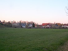
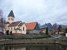
Schlagwitz (Waldenburg)
|
Punch joke
City of Waldenburg
Coordinates: 50 ° 53 ′ 43 " N , 12 ° 37 ′ 44" E
|
||
|---|---|---|
| Height : | 219 m | |
| Incorporation : | July 1, 1950 | |
| Incorporated into: | Dürrenuhlsdorf | |
| Postal code : | 08396 | |
| Area code : | 037608 | |
|
Location of Schlagwitz in Saxony |
||
Schlagwitz is a district of the city of Waldenburg in the district of Zwickau (Free State of Saxony ) on the border with Thuringia . The place was incorporated into Dürrenuhlsdorf on July 1, 1950 , with which it came to the city of Waldenburg on January 1, 1999.
geography
Geographical location
Schlagwitz is located in the northeastern urban area of Waldenburg on the border with the easternmost town of the Free State of Thuringia in the Altenburger Land . The stream flowing through the village drains into the Zwickauer Mulde .
Neighboring places
| Francs | Wolperndorf | |
| Swabia |

|
Wolkenburg / Mulde |
| Low angle | Uhlsdorf , Herrnsdorf |
history
The place goes back to a Slavic Rundling , which was later enlarged by German settlers as a row village . The name "Schlaguwitz" is documented for the year 1498. Until the 15th century, according to church sources, Schlagwitz was the "manor or knight residence" of a "Mergenthal" family. In 1492 the place was sold by Hans von Mergenthal to Götz von Ende auf Wolkenburg. Thus knock joke belonged to the 19th century with regard to the basic rule of the manor Wolkenburg . This in turn belonged to the electoral Saxon rule Wolkenburg , which as an enclave in the Schönburgic rule belonged to the electoral Saxon or royal Saxon office of Borna . Schlagwitz came to the royal Saxon court of Limbach as part of the Wolkenburg rule in 1851 and to the Penig court office in 1856 , which was merged with the Rochlitz administration in 1875 . Around 1800 mining was carried out in a mine on the Schlawitzer Flur, which belonged to the Wolkenburg Revier . The church of Schlagwitz was a parish church until 1929, with the exception of the time as a branch church of Wolkenburg (1580 to 1614). From 1929/36 the Schlagwitz church belonged to Ziegelheim as a branch church until 2001 when it became part of the Franken-Schlagwitz parish in the parish of Waldenburg.
On July 1, 1950, Schlagwitz was incorporated into Dürrenuhlsdorf , whereby the place was reclassified from the Rochlitz district to the Glauchau district . As a result of the second district reform in the GDR , Schlagwitz came to the district of Glauchau in the Chemnitz district in 1952 as a district of the municipality of Dürrenuhlsdorf (renamed the Karl-Marx-Stadt district in 1953 ), which was continued as the Saxon district of Glauchau from 1990 and in 1994 in the Chemnitzer Land district or 2008 in the district of Zwickau. With the incorporation of the municipality of Dürrenuhlsdorf, Schlagwitz became a district of the city of Waldenburg on January 1, 1999.
Individual evidence
- ↑ The Wolkenburg Castle at www.sachsens-schlösser.de
- ^ The rule of Wolkenburg with Kaufungen in the archive of the Free State of Saxony
- ↑ Wolkenburg as part of the Borna Electoral Office in the book "Geography for all Stands", p. 553
- ↑ Franken in the "Handbuch der Geograpie", p. 502
- ^ The rule of Wolkenburg in the archive of the Free State of Saxony
- ^ The Rochlitz district administration in the municipal register 1900
- ^ Arbeitsgemeinschaft Altbergbau & Geologie Westsachsen eV (Ed.): Mining in Wolkenburg - history & tradition. Beier & Beran Verlag, Langenweißbach 2006, ISBN 3-937517-59-6 .
- ↑ Schlagwitz on gov.genealogy.net
- ↑ Dürrenuhlsdorf on gov.genealogy.net
Web links
Schlagwitz in the Digital Historical Directory of Saxony


