
Neuhaus am Rennweg district
| Basic data (as of 1994) | |
|---|---|
| Existing period: | 1952-1994 |
| District : | Suhl |
| Administrative headquarters : | Neuhaus am Rennweg |
| Area : | 320.76 km² |
| Residents: | 37,212 (Dec. 31, 1989) |
| Population density: | 116 inhabitants per km² |
| License plate : | O (1953-1990) OM, ON (1974-1990) NH (1991-1994) |
| Postcodes : | 64xx (old) |
| Circle structure: | 27 municipalities (December 31, 1989) |
| Location of the district in the GDR | |
  |
|
The Neuhaus am Rennweg district , or Neuhaus / Rwg district for short. , colloquially abbreviated Kreis Neuhaus was a district in the Suhl district of the GDR . From 1990 to 1994 it existed as the district of Neuhaus am Rennweg , or district of Neuhaus a. R. , in the state of Thuringia , then it was dissolved. His area is now in the districts of Sonneberg and Saalfeld-Rudolstadt in Thuringia. The district town was Neuhaus am Rennweg . It is 830 meters above sea level and was therefore the highest district town in Germany.
geography
location
Topographically
The district area was in the ridge region of the (High) Thuringian Slate Mountains along the Rennsteig , in the upper Schwarzatal and the Gräfenthal area. The Neuhaus / Rwg district. was consistently determined by the low mountain range and, apart from the localities and some nearby, largely fallow field terraces, almost completely forested. The highest point in the district, the Great Farmdenkopf , is 869 m above sea level. NN the highest peak of the Thuringian Slate Mountains and today the storage basin of the Goldisthal pumped storage plant. The mountain peaks Kieferle (867 m above sea level) and Bleßberg (865 m above sea level) are almost the same height. The lowest point of the circle at Blechhammer on the Schwarza near Unterweißbach in the north of the district area still has a height of 323 m above sea level. NN, the valley floor of the Zopte at the end of the village of Gräfenthal on the eastern edge of the district is still approx. 30 m and the southernmost point of the district at the confluence of the Göritz in the Steinach a little more than 200 m higher. The westernmost point of the district on the Hohen Heide is 832 m above sea level. NN high and today on the border of the districts of Sonneberg and Hildburghausen .
Historical

The borders of different countries and rulers met in the original forests of the small district area. The present-day districts of the district town of Neuhaus on Rennweg Schmalenbuche and Neuhaus, the communities in the Schwarzatal, on the "Raanz" and in the Lichtetal around Oberweißbach, were part of the sovereignty of the principality of Schwarzburg-Rudolstadt in the Schwarzburg district , or were shown north of the old Rennsteig border route 1832 the office of Oberweißbach . The former municipality of Lauscha, the "southern" Neuhausen district Igelshieb, the Glücksthal desert and the municipality of Steinheid were part of the Ernestine Duchy of Saxony-Coburg , more precisely of the Meininger Oberland . Ernstthal, Spechtsbrunn, the communities on the Piesau , on the edge of the Saalfelder Höhe and around the old Graflich-Orlamünd rulership and official seat of Gräfenthal belonged to the Pappenheim rule and from 1680 to the Duchy of Saxony-Saalfeld . Saxony-Coburg-Saalfeld was united in 1826 without Coburg with the Meininger Oberland in the Duchy of Saxony-Meiningen . The Gräfenthal office remained within its limits, the municipalities of the Oberland remained part of the Sonneberg office. Until it was sold to Sachsen-Meiningen in 1772, Siegmundsburg belonged to the Schaumberg rulership and thus indirectly to the Schalkau office, Rauenstein court.


The borderline between the East Thuringian-Central German and the South Thuringian-Franconian cultural area ran through the district. The settlement of the entire region took place around the same time in the phase of early capitalism . The settlements emerged from hammer mills, glass and iron works and in connection with early mining, timber industry and oil trade . Small-scale cooperations and business relationships across the national borders of the time developed early on. The geological outcrops of the miners around Steinheid and Schmiedefeld were used by the Lauscha glassmakers, whose inventions in turn spurred the oil trade and established the porcelain industry. Carters and various trades such as lumberjacks, charcoal burners, carpenters, etc. profited from the beginning of industrialization. Customs barriers and various restrictions on foreigners hindered economic development. On the other hand, the competing princes granted multiple concessions to the emerging industries. This resulted in a relatively even distribution of medium-sized companies in the localities of the region, supplemented in the 19th century by the small businesses in the home industry. The average family income was comparatively low, however, and the possibilities for supplementing them with small-scale farming were limited due to the climatic conditions to low livestock farming such as chickens, rabbits and goats. These common living conditions rather produced a cultural togetherness.
In contrast, the dialect boundary remained. In the communities north of the Rennsteig and in the old Graefenthal office, south- east Thuringian village dialects are spoken with a Franconian touch that differs from place to place, in the Schwarzatal around Katzhütte a south-east Thuringian colored Ilmthuringian is spoken . In the Siegmundsburg-Steinheid area, Main Franconian Itzgründisch is spoken. A Main Franconian local dialect is spoken in Lauscha, and in Ernstthal a variant with a south-east Thuringian coloring, a dialect continuum that expires in the Spechtsbrunn-Piesau area in south-east Thuringia and in the Limbach-Scheibe-Alsbach-Goldisthal area in Ilmthuringia. A Lauschner subsidiary dialect also forms the basic substrate of the Neuhauser dialect, the Herrnhauser, which was gradually transformed in the 20th century by the strong influx into the emerging district town, in particular by workers for the pipe works from the wide area and by specialists from the metropolitan areas.
Important communities
The most populous communities were the district town of Neuhaus / Rwg. as well as the cities of Lauscha , Graefenthal and Oberweißbach (order according to inhabitants).
District town Neuhaus am Rennweg

City of Graefenthal

City of Lauscha

Froebelstadt Oberweißbach


Neighboring areas
The Neuhaus / Rwg district. bordered clockwise in the northeast, beginning with the (rural) districts of Rudolstadt , Saalfeld (both district of Gera ), Kronach ( Bavaria ), Sonneberg , Hildburghausen and Ilmenau ( district of Suhl ).
| District of Ilmenau | Rudolstadt district | |
| Hildburghausen district |
.svg)
|
Saalfeld district |
| Sonneberg district | District of Kronach ( Free State of Bavaria ) |
history


The Neuhaus / Rwg district was formed. on July 25, 1952 from parts of the districts of Sonneberg , Rudolstadt and Saalfeld .
On May 17, 1990, the district was renamed Neuhaus am Rennweg. The district of Neuhaus a. R. belonged until the entry into force of the Unification Treaty to Suhl district , from 3 October 1990 to the newly formed country or from 1993 the Free State of Thuringia .
coat of arms
 |
Blazon : "In the upper field on a golden background a black double-headed eagle, below in front in black a golden, left-facing lion, the rear field divided nine times by black and gold, covered with a diagonal green diamond wreath." |
| Justification for the coat of arms: The coat of arms of the district symbolized the affiliation of the district parts to the Principality of Schwarzburg-Rudolstadt ( double-headed eagle ) and the Ernestine duchies , most recently to Saxony-Meiningen (the color-reversed and reversed Meissniche lion and the Saxon diamond-shaped wreath ). The Free States of Schwarzburg-Rudolstadt and Saxony-Meiningen , which emerged from these two countries in 1918, were among the founding members of the State of Thuringia . |
District administrators
- 1990–1992: Dieter Hoffmann (CDU)
- 1992–1994: Dieter Gazda (CDU)
On July 1, 1994, the district was dissolved. The more populous southern part with the towns of Neuhaus am Rennweg, Lauscha and the municipalities of Spechtsbrunn , Ernstthal , Steinheid and Siegmundsburg as well as the north-western part with the municipalities of Goldisthal and Scheibe-Alsbach came to the Sonneberg district , the larger northern part in terms of area with the town of Oberweißbach and the Municipalities of Mellenbach-Glasbach , Meuselbach-Schwarzmühle , Katzhütte , Cursdorf , Deesbach , Lichtenhain / Bergbahn , Unterweißbach , Meura and Lichte and the town of Gräfenthal with the municipalities of Lippelsdorf , Gebersdorf (Graefenthal) , Großneundorf , Buchbach (Graefenthal) , Lichtenhain (Graefenthal) , Piesau , Schmiedefeld (Saalfeld) and Reichmannsdorf to the district of Saalfeld-Rudolstadt . Lichte and Piesau were integrated into the city of Neuhaus am Rennweg and thus into the district of Sonneberg on January 1, 2019.
Infrastructure
Industry
The places lived mainly from the glass industry and tourism . The VEB tube factory " Anna Seghers ", later VEB Mikroelektronik Neuhaus, which emerged from a Telefunken factory , employed workers from all over the district, at times up to 3000 employees. With the opening of the markets in the course of reunification, the microelectronic products of the GDR were exposed to international competition and could no longer be sold, the factory was closed. As a legacy of the former district town, Neuhaus am Rennweg has a gymnasium, the indoor swimming pool “Am Rennsteig” (built in 1980) and a modern hospital (completed in 1988), which today ensures high-quality medical care in the region, in addition to some branch offices of the Sonneberg district administration .
After the cessation of chamosite ore mining in 1972 as part of the consumer goods production of VEB ISOKO Schmiedefeld, where the QEK Junior caravans were produced from 1974 until the fall of the Wall, an ironworks in the forge mines of Maxhütte Unterwellenborn . In addition, the VEB TRISOLA glass fiber factory in Oberlauscha, the VEB TRISOLA foam glass factory Taubenbach, the VEB Thüringer Glasschmuck in Lauscha and Ernstthal, the VEB Glaskunst Lauscha in the VEB Kombinat Wohnraumkultur Erfurt, the porcelain and ceramic industry, such as the VEB Zierporzellan Lichte , VEB Wallendorfer Porzellan and VEB Zierkeramik Katzhütte , incandescent lamp production in VEB NARVA Oberweißbach, thermometer production in VEB Meßtechnik Mellenbach and traditional oil production, bundled in VEB Pharmazeutisches Werk Meuselbach, VEB Farbenfabrik Katzhütte and VEB KEFAMA, Eisenwerk Katzhütte. In the local PGH , the production of further artisanal glass products, such as figures, marbles , light mills , glass appliances , etc. was organized.

VEB TRISOLA fiberglass factory Lauscha 1972

Hungarian guest worker in VEB microelectronics "Anna Seghers" Neuhaus am Rennweg 1977
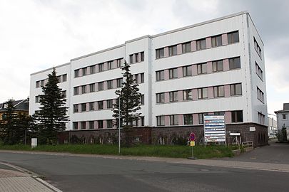
Former administration building of the pipe works and the VEB Microelectronics "Anna Seghers" Neuhaus am Rennweg (2013)


Agriculture and Forestry
Agriculture played a subordinate role. In addition to a few small farms, the LPG (T) Lichte-Oberweißbach developed an economically noteworthy cattle rearing department, in 1969 the Haflinger Stud Meura, from 1976 VEG , emerged from the horse breeding department . The impossibility of self-sufficiency in crops due to the harsh mountain climate led to the nickname "Kustelkreis" (Kustel = spruce cones ), the one in the late 1980s, free-standing sculpture , the "Kustelbrunnen" on the building of the district council was dedicated. In contrast, forestry was more important. The Kernstal sawmill was built in the Schwarzatal near Schwarzmühle.

State forestry enterprise Neuhaus am Rennweg 1981

Agriculture in the Neuhaus am Rennweg district in 1983

Meura Haflinger Stud 1986

Kustelbrunnen at the former district administration


traffic

The branch lines Probstzella – Neuhaus am Rennweg , Sonneberg – Ernstthal am Rennsteig and Rottenbach – Katzhütte (Schwarzatalbahn) were the life arteries of the district. With the Oberweißbacher mountain railway , the district also had a tourist highlight. Local public transport was provided by VEB Kraftverkehr Neuhaus am Rennweg, which set up and operated a bus station, which is very busy during rush hour, near the pipe works. A trunk road crossing the Rennsteig and the mountain ridge, today's B 281 , connected the district with the district town of Suhl and the district towns of Hildburghausen and Meiningen on the one hand and the traffic junction Saalfeld on the other. The connection to the distant highways was poor. Due to the severe winters, the district road network required a lot of maintenance, but this was neglected. After the fall of the Wall, the district Neuhaus am Rennweg was responsible for redevelopment, including the previously almost inaccessible restricted area with the help of EU funds .
tourism
The freely accessible district area was developed for inland tourism, which was of great economic importance for the district. There were a number of rest homes and summer camps. In the then restricted area near Spechtsbrunn auf dem Brand there was a MfS holiday resort .
Sports

Although every community had at least one football sports community, none of the teams reached higher-class leagues in the long term. The most successful was the BSG Chemie Lauscha with seasons in the DS league and the II. DDR league (1950-1963). Their winter sports , sporting home and a. of the national and national ski jumping trainer Reinhard Heß , the vice world champion in ski flying Axel Zitzmann and the German champion and two-time World Cup winner André Kiesewetter , all SC Motor Zella-Mehlis , judged the X German championships in 1959 and the GDR championships in 1976 and 1984 Nordic disciplines. In addition to the Marktiegelschanze there were ski jumps in Neuhaus am Rennweg (Bärenschanze and Schanzen im Gründle), Ernstthal (Pappenheimer Schanze, Königswiesenschanze and Schanze am Hasenrangen), Lichte-Bock and Teich (Teichschanze), Cursdorf (giant ski jump on Rosenberg and Königstalschanzen), Steinheid (Schanzen am Teufelsgrund), Oberweißbach (Friedrich-Fröbel-Schanze) and Scheibe-Alsbach (Schanze am Friedrichshöher Steig), all of which are no longer in operation today. Extensive cross- country trails have been and are being groomed in the region .
Culture

In all cities and in the larger municipalities, such as Ernstthal and Goldisthal, there were cultural centers in traditional inns with dining rooms (Lauscha) or new buildings from the 1950s. In the district culture house Neuhaus / Rwg. The ensemble of the Rudolstadt Theater and the Suhl Philharmonic Orchestra performed regularly . The own musical landscape was initially grouped around the folk dance ensemble of the Röhrenwerk "Anna Seghers" and the school and company choirs. In the 1980s, a dialect rock amateur band scene emerged with the flagships Bromm Oss and Von oom, which are known throughout the GDR . The glass art around Albin Schaedel , Volkhard Precht and Albrecht Greiner-Mai (all NPT ) was of outstanding international importance, and the regional literature around Wally Eichhorn-Nelson and the visual arts ( Günter Dührkop ) were known throughout the country . The Museum für Glaskunst Lauscha had and still has significance in the art world .
education
In the cities and the larger municipalities, such as Lichte, there were polytechnic high schools with school buildings for the lower grades in every village. In the district town of Neuhaus / Rwg. there was an advanced high school and a vocational school . Every place had at least one kindergarten , the pioneer of which, Friedrich Froebel , comes from Oberweißbach in the district and whose memory has been and is kept very much alive here.
Landmarks
The transmitter Bleßberg , located in the extreme southwest of the district area, marks today at around 1060 m above sea level. NHN (865 m site height + 195.1 m tower height) the highest artificial point in Thuringia. The transmission tower was and is not open to the public. An observation tower on the Bleßberg plateau was demolished in 1972. A new observation tower has stood on the plateau since 1997. With the Fröbelturm (785 m above sea level) near Oberweißbach, the Meuselbacher Kuppe (786 m above sea level) and the Leipzig tower (802 m above sea level) near Schmiedefeld, the district had striking vantage points as hiking destinations. The Bornhügel (846 m above sea level) in the urban area of Neuhaus am Rennweg houses a water tower and a meteorological station.
Dams
Large-scale hydraulic engineering projects, the Leibis-Lichte dam with an elaborate cavern system and the Goldisthal pumped storage plant , were planned and partially tackled, but all of them were only completed after the district was dissolved. The residents of Leibis in the Lichtetal were relocated to the newly built Neu-Leibis near Mellenbach .
Border installations
The southeast border of the district was part of the inner-German border . Therefore, the district was affected by extensive border security measures. In fact, the confusing borderline was used several times to attempt to escape . As a result of the basic treaty of 1973, some simplifications were introduced, in particular the use of traffic routes was released. However, the city of Gräfenthal with the districts of Meernach and Creunitz and the communities of Buchbach, Lichtenhain bei Gräfenthal and Spechtsbrunn were still in the restricted border area and were only accessible to residents and holders of a pass that had to be applied for from the People's Police District Office (VPKA). These restrictions also affected the maternity ward and the surgery of the district hospital, which were located in a small clinic in Graefenthal until well into the 1980s. A military radar system was located on the Rittersberg hill (837 m above sea level) near Steinheid, which is adjacent to the Kieferle. These and the border installations have now been dismantled, but a residual risk remained directly on the former border strip on the border with the Kronach district due to possible landmines that were not found .
License Plate
Motor vehicles (with the exception of motorcycles) and trailers were assigned the two-letter combination OB from 1953 , and three-letter distinguishing signs from around 1974 to the end of 1990, which began with the letter pairs OM and ON . The last number plate series used for motorcycles was OS 90-01 to OS 99-99 .
At the beginning of 1991 the district received the distinguishing mark NH . It was issued until June 30, 1994. It has been available in the Sonneberg district since November 29, 2012 .
Individual evidence
- ↑ Southeast Thuringian on the pages of the Thuringian Dialect Research Unit of the Friedrich Schiller University Jena
- ^ Ilmthuringian on the pages of the Thuringian Dialect Research Unit of the Friedrich Schiller University Jena
- ↑ Itzgründisch on the pages of the Thuringian Dialect Research Unit of the Friedrich Schiller University Jena ( Memento of the original from October 29, 2012 on WebCite ) Info: The archive link was inserted automatically and has not yet been checked. Please check the original and archive link according to the instructions and then remove this notice.
- ↑ a b Federal Statistical Office (ed.): Municipalities 1994 and their changes since January 1, 1948 in the new federal states . Metzler-Poeschel, Stuttgart 1995, ISBN 3-8246-0321-7 .
- ↑ Law on the self-administration of municipalities and districts in the GDR (municipal constitution) of May 17, 1990
- ↑ Six district administrators served: Head of the school administration office in Saalfeld-Rudolstadt is retiring. In: otz.de. December 22, 2015, accessed November 23, 2019 .
- ↑ Heinz-Peter Hoffmann: Daun-Neuhaus - interim balance of partnership relationships. In: heimatjahrbuch-vulkaneifel.de. June 1992, accessed November 23, 2019 .
- ^ Norbert Moczarski et al: Thüringisches Staatsarchiv Meiningen. Department of the Regional Economic Archive South Thuringia in Suhl . A brief inventory overview. Ed .: Thuringian State Archives Meiningen. 1st edition. Druckhaus Offizin Hildburghausen, 1994, Development of traditional industrial areas in South Thuringia until 1990, p. 16-24 .
- ↑ Andreas Herzfeld: The history of the German license plate . 4th edition. German Flag Society V., Berlin 2010, ISBN 978-3-935131-11-7 , pp. 302 .
- ↑ Andreas Herzfeld: The history of the German license plate . 4th edition. German Flag Society V., Berlin 2010, ISBN 978-3-935131-11-7 , pp. 553 .
Web links
1922–1952: Altenburg | Altenburg (city) | Apolda (city) | Arnstadt | Arnstadt (city) | District Department Camburg | Eisenach | Eisenach (city) | Erfurt | Erfurt (city) | Gera | Gera (city) | Gotha | Gotha (city) | Greiz | Greiz (city) | Heiligenstadt | Hildburghausen | County of Hohenstein | Ilfeld | Jena | Jena (city) | Langensalza | Meiningen | Mulhouse | Mühlhausen (city) | Nordhausen (city) | Rudolstadt | Saalfeld | Schleiz | Schleusingen | Reign of Schmalkalden | Sondershausen | Sonneberg | Stadtroda | Weimar | Weimar (city) | Weissensee | Worbis | Zella-Mehlis (city) | Ziegenrück . 1952–1994: Altenburg | Apolda | Arnstadt | Artern | Bad Salzungen | Eisenach | Eisenberg | Erfurt-Land | Erfurt (city) | Gera-Land | Gera (city) | Gotha | Greiz | Heiligenstadt | Hildburghausen | Ilmenau | Jena-Land | Jena (city) | Langensalza | Lobenstein | Meiningen | Mulhouse | Neuhaus / Rwg. | Nordhausen | Pößneck | Rudolstadt | Saalfeld | Schleiz | Schmalkalden | Schmölln | Sömmerda | Sondershausen | Sonneberg | Stadtroda | Suhl-Land | Suhl (city) | Weimar-Land | Weimar (city) | Worbis | Zeulenroda .