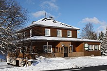
Buchbach (Graefenthal)
|
Buchbach
City of Graefenthal
Coordinates: 50 ° 30 ′ 25 ″ N , 11 ° 17 ′ 15 ″ E
|
||
|---|---|---|
| Height : | 458 m | |
| Residents : | 110 | |
| Incorporation : | April 9, 1994 | |
| Postal code : | 98743 | |
| Area code : | 036703 | |
|
Location of Buchbach in Thuringia |
||
Buchbach is a district of the city of Gräfenthal in the Saalfeld-Rudolstadt district in Thuringia .
location
The district is located southwest of Graefenthal in the Thuringian Slate Mountains and can be reached via Landesstraße 1150 and Kreisstraße 176. The cropped area of the village lies in a typical low mountain range. It is characterized by valley, slope and altitude. Clearing islands and areas are still recognizable. Along the meandering stream of the same name, the Old Trade and Army Road leads from Gräfenthal to Buchbach and further.
history
The village was first mentioned in a document in 1180. Forestry and, to a limited extent, agriculture are, alongside tourism, sources of income for the 151 people living in the village.
On April 9, 1994 (date of legal effect) the place was incorporated into Graefenthal.
Individual evidence
- ↑ Buchbach on the website of the city of Gräfenthal.Retrieved on April 6, 2020
- ^ Wolfgang Kahl : First mention of Thuringian towns and villages. A manual. 5th, improved and considerably enlarged edition. Rockstuhl, Bad Langensalza 2010, ISBN 978-3-86777-202-0 , p. 43.
- ↑ Thuringian State Office for Statistics - Area changes in the municipality of Gräfenthal

