Hohenölsen
|
Hohenölsen
City of Weida
|
|
|---|---|
| Coordinates: 50 ° 44 ′ 15 ″ N , 12 ° 4 ′ 57 ″ E | |
| Height : | 372 m above sea level NHN |
| Residents : | 450 (December 31, 2012) |
| Incorporation : | December 31 2013 |
| Postal code : | 07570 |
| Area code : | 036603 |
|
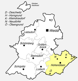
Location of Hohenölsen in Weida
|
|
Hohenölsen is a district of the city of Weida in the Greiz district in Thuringia .
geography
Hohenölsen is located on a hill in the Thuringian Vogtland on the federal highway 92 between Weida and Greiz .
The villages of Neudörfel , Kleindraxdorf , Horngrund and Ölsengrund also belong to Hohenölsen .
history
Under the governors of Weida, land development began in the 12th century with the construction of villages and castles.
According to legend, the site, first mentioned in 1356, was built by miners who dug for silver in the Leuba valley. An associated field name "Silberloch" is attached to an abandoned quarry (today identified and protected as a geotope). Until 1918/19 Hohenölsen was divided into two parts. While the greater part of the village belonged to the Weida office , the old manor with its possessions and the Neudörfel district was an enclave of the small principality Reuss older line . The small town of Kleindraxdorf, located a few hundred meters northeast of Hohenölsen, used to be an important post office on the road from Plauen to Leipzig .
On October 1, 1922, the Russian and Weimaraner portions of the community were merged. From 1991 Hohenölsen was a member of the Leubatal administrative community . Since this was dissolved on December 31, 2013, Hohenölsen was incorporated into the city of Weida .
Population development
Development of the population (from December 31, 1994) :
|
|
|
|
- Data source from 1994: Thuringian State Office for Statistics
Culture and sights
The village church of Hohenölsen still shows Romanesque style features from the time it was built. Built at the highest point of the village, the church also served as a burial place for the noble owners of the neighboring manor. The former manor house was demolished during the GDR era, and medium-sized businesses were able to settle in the dilapidated farm building. The estate park extends on the western edge of the village. A large pond is also in the immediate vicinity of the church, surrounded by the former village school and the “Zur Rotbuche” inn. The historic town center continues in an easterly direction down the valley and consists mainly of four-sided courtyards.
Economy and Infrastructure
The largest employer in the area is a production facility of Breckle GmbH, a mattress and upholstered bed manufacturer.
With its central location in the district of Greiz, Hohenölsen is a transfer point for the regional buses of PRG Greiz . Lines 27, 28, 29 and 34 start and end here. You drive on the federal and connecting roads to Wildenaube, Weida, Hohenleuben and Loitsch. The transfer point is on the Anger in the middle of the village.
| line | route | Tact |
|---|---|---|
| PRG 27 | Greiz - Wild pigeon - Hohenölsen | HVZ: every hour, NVZ: every two hours |
| PRG 28 | Zeulenroda - Hohenleuben - Hohenölsen | HVZ: every hour, NVZ: every two hours |
| PRG 29 | Hohenölsen - Weida - Gera | hourly |
| PRG 34 | Weida - Steinsdorf - Hohenölsen | single trips |
Personalities
- Hans Adolf von Spitznas (* 1699 in Hohenölsen; † March 22, 1758 in Saaz), Württemberg lieutenant general
- Paul Fischer (born October 17, 1894 in Hohenölsen, † November 18, 1979 in Greiz) was a German sailor, fighter against the Kapp Putsch, local and state politicians (Spartakusbund / USPD / KPD / KPO) and publisher
literature
- The northern Vogtland around Greiz . A geographical inventory in the area of Greiz, Weida, Berga, Triebes, Hohenleuben, Elsterberg, Mylau and Netzschkau. In: Leibniz Institute for Regional Geography (Ed.): Landscapes in Germany . tape 68 . Böhlau Verlag, Leipzig 2006, ISBN 3-412-09003-4 , Hohenölsen with Neudörfel and Kleindraxdorf, Greiz district, p. 137-140 .


