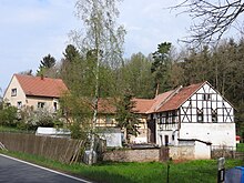
Horngrund
Horngrund is a property consisting of two residential buildings in the eastern tip of the Hohenölsen district in the town of Weida in the Greiz district in Thuringia .
location
The Harnbach is a left tributary of the Weida and drains the valley floor from Hohenölsen to Clodra . Horngrund is located directly on Landesstraße 1083, about one kilometer west of Dittersdorf . A high-voltage line runs right next to the two houses.
history
After 1890, a clay pit intended for local building material requirements was laid on a narrow strip of field between the main road and the Harnbach, and a brick factory was built. The first houses for the workers were built right next to the brickworks after 1910, these buildings were originally called "Harnhäuser", derived from "Harngrund". The residents feared being mocked, so the place name was later changed to "Horngrund" with official approval. On December 31, 2013, Horngrund also became a district of this town through Hohenölsen's incorporation into Weida .
literature
- The northern Vogtland around Greiz . A geographical inventory in the area of Greiz, Weida, Berga, Triebes, Hohenleuben, Elsterberg, Mylau and Netzschkau. In: Leibniz Institute for Regional Geography (Ed.): Landscapes in Germany . tape 68 . Böhlau Verlag, Leipzig 2006, ISBN 3-412-09003-4 , Hohenölsen with Neudörfel and Kleindraxdorf, Greiz district, p. 137-140 .
Web links
Individual evidence
- ↑ Historisches Mestischblatt 5238 (Weida) - edition 1906
Coordinates: 50 ° 44 ′ 39.5 ″ N , 12 ° 6 ′ 40.8 ″ E

