
Kottgeisering
| coat of arms | Germany map | |
|---|---|---|

|
Coordinates: 48 ° 7 ' N , 11 ° 8' E |
|
| Basic data | ||
| State : | Bavaria | |
| Administrative region : | Upper Bavaria | |
| County : | Fürstenfeldbruck | |
| Management Community : | Grafrath | |
| Height : | 542 m above sea level NHN | |
| Area : | 8.21 km 2 | |
| Residents: | 1608 (Dec. 31, 2019) | |
| Population density : | 196 inhabitants per km 2 | |
| Postal code : | 82288 | |
| Area code : | 08144 | |
| License plate : | FFB | |
| Community key : | 09 1 79 131 | |
| Community structure: | 3 parts of the community | |
| Address of the municipal administration: |
Ammerseestrasse 7 82288 Kottgeisering |
|
| Website : | ||
| Mayor : | Andreas Folger (Citizens' Association) | |
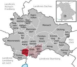
| Location of the municipality of Kottgeisering in the Fürstenfeldbruck district | ||
  |
||


Kottgeisering is a municipality in the Upper Bavarian district of Fürstenfeldbruck and a member of the Grafrath administrative community . It is located around eleven kilometers southwest of Fürstenfeldbruck and 34 kilometers west of Munich .
Community structure
The municipality has three officially named municipal parts (the type of settlement is indicated in brackets ):
- Grafrath (settlement)
- Kottgeisering ( Kirchdorf )
- Reichertsried ( wasteland )
history
Settlement finds in Kottgeisering go back to the late Hallstatt period , from which several burial mounds originate. An early medieval royal grave dates from the 7th century . The first documentary mention is 829 as "Kysalheringas" (meaning: With the people of Kysalher / Giselher). The prefix “Koth / Kott-” has been customary since the 13th century to distinguish the boggy, “kothige” Kottgeisering from the more conveniently located Schöngeising .
Population development
Between 1988 and 2018, the municipality grew from 1,323 to 1,567 by 244 inhabitants or 18.4%.
politics
Municipal council
In the 2020 local elections , the council was filled as follows:
- CSU : 3 seats (28.36%)
- Citizens' association : 3 seats (27.64%)
- Greens : 3 seats (21.36%)
- Free voters : 2 seats (14.92%)
- SPD : 1 seat (7.72%).
The turnout was 71.98%.
mayor
Andreas Folger (Citizens' Association) has been at the head of the community since May 1, 2020; he was elected as the successor to Sandra Meissner.
coat of arms
The description of the coat of arms is as follows: Double coat of arms: In front, in blue on a golden three-mountain, a silver heron with a fish in its beak; In the background on the right the diamond coat of arms is offset .
Architectural monuments
Soil monuments
See: List of ground monuments in Kottgeisering
Web links
- Kottgeisering: Official statistics of the LfStat (PDF; 1.66 MB)
Individual evidence
- ↑ "Data 2" sheet, Statistical Report A1200C 202041 Population of the municipalities, districts and administrative districts 1st quarter 2020 (population based on the 2011 census) ( help ).
- ^ Community Kottgeisering in the local database of the Bayerische Landesbibliothek Online . Bavarian State Library, accessed on September 10, 2019.
- ^ Entry on the coat of arms of Kottgeisering in the database of the House of Bavarian History
- ↑ The coat of arms is used without official approval because its design contradicts the rules applicable to Bavarian municipal coats of arms.

Adelshofen | Alling | Althegnenberg | Egenhofen | Eichenau | Emmering | Fürstenfeldbruck | Germering | Grafrath | Groebenzell | Hattenhofen | Jesenwang | Kottgeisering | Landsberied | Maisach | Mammendorf | Mittelstetten | Moorenweis | Oberschweinbach | Olching | Puchheim | Schöngeising | Turk field