
Mittelstetten (Upper Bavaria)
| coat of arms | Germany map | |
|---|---|---|

|
Coordinates: 48 ° 15 ' N , 11 ° 6' E |
|
| Basic data | ||
| State : | Bavaria | |
| Administrative region : | Upper Bavaria | |
| County : | Fürstenfeldbruck | |
| Management Community : | Mammendorf | |
| Height : | 514 m above sea level NHN | |
| Area : | 18.62 km 2 | |
| Residents: | 1713 (Dec. 31, 2019) | |
| Population density : | 92 inhabitants per km 2 | |
| Postal code : | 82293 | |
| Area code : | 08202 | |
| License plate : | FFB | |
| Community key : | 09 1 79 137 | |
| Community structure: | 6 parts of the community | |
| Address of the municipal administration: |
Schulstr. 11 82293 Mittelstetten |
|
| Website : | ||
| Mayor : | Franz Ostermeier (We for our community) | |
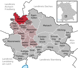
| Location of the community of Mittelstetten in the Fürstenfeldbruck district | ||
  |
||


Mittelstetten is a municipality in the Upper Bavarian district of Fürstenfeldbruck and a member of the Mammendorf administrative community .
geography
The place is about 20 kilometers southeast of Augsburg and 13 kilometers northwest of Fürstenfeldbruck .
The municipality has six officially named municipality parts :
- Mittelstetten ( parish village )
- Oberdorf ( Kirchdorf )
- Tegernbach (Kirchdorf)
- Vogach (Kirchdorf)
- Längenmoos ( village )
- Hanshofen ( hamlet )
history
Until the church is planted
Mittelstetten was first mentioned in 788 as Mouitilstat (residence of Mutilo), when Duke Tassilo III. gave the place and church to the Benediktbeuern monastery. Around 1200 three names were mentioned as "Milites in Muotelinsten", i.e. knights of Mittelstetten. In the late 13th century, goods in Mittelstetten were transferred to the newly founded Fürstenfeld monastery . At the beginning of the 16th century the monastery had three courtyards and a tavern in Mittelstetten. The latter was an important rest stop for travelers from Munich to Augsburg .
In 1818 the community was formed together with the districts of Hanshofen, Längenmoos and Vogach.
Incorporations
On July 1, 1972, the municipality part of Oberdorf Mittelstetten, which had previously belonged to the municipality of Baierberg, was slammed. On May 1, 1978, the previously independent municipality of Tegernbach was incorporated.
Population development
Between 1988 and 2018 the community grew from 1,316 to 1,699 inhabitants or by 29.1%.
politics
mayor
Franz Ostermeier (We for our community) has been mayor since May 1, 2020. In the election on March 15, 2020 , he received 58.2% of the votes against his predecessor Andreas Spörl ( CSU , in office from 2014 to 2020).
Municipal council
In the 2020 local elections , the council was filled as follows:
- CSU : 4 seats (33.32%)
- We for our community : 5 seats (41.47%)
- Close to the citizen and independent: 3 seats (25.21%).
The turnout was 74.27%.
coat of arms
The description of the coat of arms adopted in 1982 reads: “Split by a silver arrow of red and green; in front half a silver flight, behind a narrow silver wave bar, covered by an upright pitchfork, the handle of which grows from a silver spade leaf. "
Architectural monuments
Soil monuments
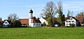
Oberdorf from the east

St. John the Baptist in Vogach


Web links
- Entry on the coat of arms of Mittelstetten (Upper Bavaria) in the database of the House of Bavarian History
- Mittelstetten (Upper Bavaria): Official statistics of the LfStat (PDF; 1.66 MB)
Individual evidence
- ↑ "Data 2" sheet, Statistical Report A1200C 202041 Population of the municipalities, districts and administrative districts 1st quarter 2020 (population based on the 2011 census) ( help ).
- ^ Mittelstetten community in the local database of the Bavarian State Library Online . Bavarian State Library, accessed on September 10, 2019.
- ^ Wilhelm Volkert (ed.): Handbook of Bavarian offices, communities and courts 1799–1980 . CH Beck, Munich 1983, ISBN 3-406-09669-7 , p. 466 .
- ^ Federal Statistical Office (ed.): Historical municipality directory for the Federal Republic of Germany. Name, border and key number changes in municipalities, counties and administrative districts from May 27, 1970 to December 31, 1982 . W. Kohlhammer, Stuttgart / Mainz 1983, ISBN 3-17-003263-1 , p. 577 .

Adelshofen | Alling | Althegnenberg | Egenhofen | Eichenau | Emmering | Fürstenfeldbruck | Germering | Grafrath | Groebenzell | Hattenhofen | Jesenwang | Kottgeisering | Landsberied | Maisach | Mammendorf | Mittelstetten | Moorenweis | Oberschweinbach | Olching | Puchheim | Schöngeising | Turk field