
Alling
| coat of arms | Germany map | |
|---|---|---|

|
Coordinates: 48 ° 8 ' N , 11 ° 18' E |
|
| Basic data | ||
| State : | Bavaria | |
| Administrative region : | Upper Bavaria | |
| County : | Fürstenfeldbruck | |
| Height : | 550 m above sea level NHN | |
| Area : | 21.02 km 2 | |
| Residents: | 3941 (Dec. 31, 2019) | |
| Population density : | 187 inhabitants per km 2 | |
| Postal code : | 82239 | |
| Area code : | 08141 | |
| License plate : | FFB | |
| Community key : | 09 1 79 113 | |
| LOCODE : | DE 3AA | |
| Community structure: | 10 parish parts | |
| Address of the municipal administration: |
Am Kirchberg 6 82239 Alling |
|
| Website : | ||
| First Mayor : | Stefan Joachimsthaler (CSU) | |
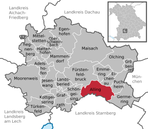
| Location of the municipality of Alling in the Fürstenfeldbruck district | ||
  |
||

Alling is a municipality and a town in the southeast of the Upper Bavarian district of Fürstenfeldbruck, about 25 kilometers west of Munich .
Community structure
The municipality has 10 officially named parts of the municipality (the type of settlement is given in brackets ):
|
|
history
Until the church is planted
The first documentary mention was in 802 as Allingas and Allinga (among the people of Allo), for Biburg around 1150 as Piburch and for Holzhausen 776 as Holzhusun (houses on the forest). After the individual places belonged to different monasteries from the 9th century, the community of Alling was created as a result of secularization in 1812.
20th century
There were political tensions with the residents of the Eichenau district , which was established before 1900 . In 1925, the majority of the Eichenau municipal councils decided to move the municipal administration to Eichenau. After 1945 the population increased enormously due to the influx of refugees and displaced persons.
Outsourcing
On April 1, 1957, Eichenau became an independent municipality by hiving off from Alling.
Incorporations
On May 1, 1978, the previously independent community of Holzhausen, the community of Biburg without the Pfaffing community and the Wagelsried community from the Emmering community were incorporated.
Population development
Between 1988 and 2018, the municipality grew from 2,845 to 3,903 by 1,058 inhabitants or 37.2%.
politics
| year | CSU | Allinger Citizens Association (ABV) | Biburg-Holzhausen village community ( voter group ) |
Green | Village community of free voters |
SPD | Citizenship e. V. ( voter group ) | total | Voter turnout in% |
|---|---|---|---|---|---|---|---|---|---|
| 2020 | 4th | 3 | 3 | 2 | 2 | 1 | 1 | 16 | 75.77 |
| 2014 | 6th | Not started | 3 | Not started | 4th | 2 | 1 | 16 | 72.2 |
| 2008 | 7th | Not started | 3 | Not started | 3 | 1 | 2 | 16 | 71.9 |
| 2002 | 6th | Not started | 3 | Not started | 4th | 1 | 2 | 16 | 74.2 |
Mayor has been Stefan Joachimsthaler since May 1, 2020; he achieved 54.37% of the vote in the runoff election. His predecessor was Frederik Röder (CSU) since 2002; he did not stand for re-election.
Attractions
The Hoflach Chapel , which is reminiscent of the Battle of Alling, is worth seeing . In this battle in 1422 the hostile armies of the Wittelsbach dukes Ernst of Bavaria-Munich and Ludwig the Bearded of Bavaria-Ingolstadt, who were fighting for their inheritance, clashed . Out of gratitude for his victory, Duke Ernst had the chapel built in the years that followed and decorated with a seven-meter-long fresco. The chapel is privately owned and only accessible on special occasions.
Soil monuments

Parish Church of the Birth of Mary

View from the Burgstall over the town


Economy and Infrastructure
economy
In 1998 there were 13 employees in the field of agriculture and forestry, 222 in manufacturing and 83 in the field of trade and transport. In other economic sectors 102 people were employed at the place of work subject to social security contributions. There were a total of 1055 employees at the place of residence subject to social security contributions. There was one company in the manufacturing industry (as well as mining and quarrying of stones and earth) and five companies in the construction industry. In addition, in 1999 there were 54 farms with an agriculturally used area of 1500 ha. Of this, 1311 ha were arable land and 187 ha were permanent green areas.
traffic
Alling is connected to the MVV network with the express bus route X900 in the direction of Starnberg or Buchenau, the express bus route X920 in the direction of Klinikum Großhadern or Buchenau and the regional bus route 852 to Germering . The MVV RufTaxi 8500 runs to remote stops. Alling is connected to Bundesstraße 2 near Hoflach .
education
There are the following facilities:
- Day nursery
- kindergarten
- primary school
- Daycare
Personalities
- Hans Friedl (* 1957), member of the Bavarian State Parliament
literature
- v. Braunmühl: The underground passages of the destroyed Rockenstein Castle near Alling, Bruck District Court. In addition to an appendix about the underground passages to Nanhofen and Mergentau by v. Hefner and Illing. In: Upper Bavarian Archive for Patriotic History , Volume 3, Munich 1841, pp. 397–411 ( online )
- Jacob Groß: Some news about the Burgstelle and Schwaige Rockenstein (Roggenstein) in the district of Bruck in Upper Bavaria . In: Upper Bavarian Archive for Fatherland History (Historischen Verein von Oberbayern, ed.), Volume 36, Munich 1877, pp. 13–24 ( online ).
Web links
- Homepage
- Entry on the coat of arms of Alling in the database of the House of Bavarian History
- Alling: Official statistics of the LfStat (PDF; 1.7 MB)
Individual evidence
- ↑ "Data 2" sheet, Statistical Report A1200C 202041 Population of the municipalities, districts and administrative districts 1st quarter 2020 (population based on the 2011 census) ( help ).
- ^ Municipality of Alling: Greetings from the mayor. Retrieved May 10, 2020 .
- ^ Community Alling in the local database of the Bavarian State Library Online . Bavarian State Library, accessed on September 10, 2019.
- ^ Wilhelm Volkert (ed.): Handbook of Bavarian offices, communities and courts 1799–1980 . CH Beck, Munich 1983, ISBN 3-406-09669-7 , p. 466 .
- ^ Federal Statistical Office (ed.): Historical municipality directory for the Federal Republic of Germany. Name, border and key number changes in municipalities, counties and administrative districts from May 27, 1970 to December 31, 1982 . W. Kohlhammer, Stuttgart / Mainz 1983, ISBN 3-17-003263-1 , p. 577 .
- ↑ Bavarian State Office for Statistics and Data Processing (Hrsg.): The municipalities of Bavaria according to the territorial status May 25, 1987. The population of the municipalities of Bavaria and the changes in the acquisitions and territory from 1840 to 1987 (= contributions to Statistics Bavaria . Issue 451). Munich 1991, p. 46 , urn : nbn: de: bvb: 12-bsb00070717-7 ( digitized version - footnote 2).
- ^ Result of the 2014 municipal council election on March 16, 2014 from alling.de. Retrieved May 22, 2015
- ↑ New MVV RufTaxi 8500 from September 15. (No longer available online.) MVV, September 16, 2015, archived from the original on December 1, 2017 ; accessed on November 27, 2017 . Info: The archive link was inserted automatically and has not yet been checked. Please check the original and archive link according to the instructions and then remove this notice.

Adelshofen | Alling | Althegnenberg | Egenhofen | Eichenau | Emmering | Fürstenfeldbruck | Germering | Grafrath | Groebenzell | Hattenhofen | Jesenwang | Kottgeisering | Landsberied | Maisach | Mammendorf | Mittelstetten | Moorenweis | Oberschweinbach | Olching | Puchheim | Schöngeising | Turk field