Moorenweis
| coat of arms | Germany map | |
|---|---|---|

|
Coordinates: 48 ° 9 ' N , 11 ° 5' E |
|
| Basic data | ||
| State : | Bavaria | |
| Administrative region : | Upper Bavaria | |
| County : | Fürstenfeldbruck | |
| Height : | 566 m above sea level NHN | |
| Area : | 45.45 km 2 | |
| Residents: | 4159 (Dec. 31, 2019) | |
| Population density : | 92 inhabitants per km 2 | |
| Postal code : | 82272 | |
| Area code : | 08146 | |
| License plate : | FFB | |
| Community key : | 09 1 79 138 | |
| Community structure: | 15 parts of the community | |
| Address of the municipal administration: |
Ammerseestr. 8 82272 Moorenweis |
|
| Website : | ||
| Mayor : | Josef Schäffler ( CSU ) | |
| Location of the municipality of Moorenweis in the Fürstenfeldbruck district | ||
Moorenweis is a municipality in the west of the Fürstenfeldbruck district in the administrative district of Upper Bavaria .
geography
Moorenweis is about 14 kilometers west-southwest of Fürstenfeldbruck . The source of the Maisach is located in the municipality .
The municipality has 15 officially named municipality parts :
|
|
|
history
Until the church is planted
Moorenweis was first mentioned around 753 in a document from the Wessobrunn monastery . From the 13th century until the secularization in 1803, the monastery was the most important manor in the area. The municipality of Moorenweis was established in 1818.
Incorporations
On the occasion of the municipal area reforms in Bavaria , Moorenweis was enlarged on July 1, 1972 to include the former municipalities of Dünzelbach, Eismerszell, Purk and Steinbach. Grunertshofen was added on May 1, 1978.
Population development
Between 1988 and 2018, the municipality grew from 2938 to 4109 inhabitants or by 39.9%.
politics
mayor
Joseph Schäffler (CSU) has been mayor since 2002.
Municipal council
The municipal council, which has been in office since May 1, 2014, is composed as follows:
- CSU 8 seats
- Civic Association 6 seats
- Community 2 seats
coat of arms
Description of coat of arms
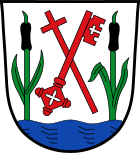
Two black moss cobs with green stems and green leaves growing in silver from a blue corrugated shield base; a red cross stick and a red key crossed diagonally in between.
Coat of arms history
The Wellenschildfuß and growing from moss piston ( cattail ) refer to the location of the municipality in the headwaters of Maisach and typical in the wetlands flora. They also give a fitting picture for the community name alluding to moor meadows. The red cross staff, attribute of St. Sixtus , symbolizes the patron saint of the parish church Moorenweis and the historical importance of the parish church as a manor. The key is the reduction of the monastery coat of arms of Wessobrunn (two crossed keys) and reminds of the possessions of the monastery in Moorenweis, which can be documented as early as the 13th century, and the most important manorial rule in the village up to the secularization of 1803. The colors white and red refer to the parish belonging to the diocese of Augsburg .
Attractions
- Catholic parish church St. Sixtus in Moorenweis
- Catholic parish church of St. Nikolaus in Dünzelbach
Soil monuments
See: List of soil monuments in Moorenweis
economy
The economy is characterized by agricultural, forestry and medium-sized businesses.
traffic
The state road 2054 crosses Moorenweis. The place is part of the Munich Transport and Tariff Association . Moorenweis is connected to local public transport with four bus lines and a RufTaxi. The nearest train stations are in the neighboring communities of Grafrath and Türkenfeld. From there, the S-Bahn line S4 runs towards Munich or Geltendorf.
There are no bike path connections, neither in neighboring districts nor in neighboring communities. The construction of a cycle path that had been planned for decades along State Road 2054 towards Jesenwang was finally canceled in 2010 due to financial uncertainties, although the project was about to make a positive decision. A realization is therefore no longer expected in the foreseeable future. Linked to this is a planned road-side cycle path connection to Grafrath train station has moved further into the distance.
Web links
- Entry on the coat of arms of Moorenweis in the database of the House of Bavarian History
- Moorenweis: Official statistics of the LfStat (PDF; 1.66 MB)
Individual evidence
- ↑ "Data 2" sheet, Statistical Report A1200C 202041 Population of the municipalities, districts and administrative districts 1st quarter 2020 (population based on the 2011 census) ( help ).
- ^ Municipality of Moorenweis in the local database of the Bavarian State Library Online . Bavarian State Library, accessed on September 10, 2019.
- ^ Wilhelm Volkert (ed.): Handbook of Bavarian offices, communities and courts 1799–1980 . CH Beck, Munich 1983, ISBN 3-406-09669-7 , p. 466 .
- ^ Federal Statistical Office (ed.): Historical municipality directory for the Federal Republic of Germany. Name, border and key number changes in municipalities, counties and administrative districts from May 27, 1970 to December 31, 1982 . W. Kohlhammer, Stuttgart / Mainz 1983, ISBN 3-17-003263-1 , p. 577 .


