
Fürstenfeldbruck district
| coat of arms | Germany map |
|---|---|

|

Coordinates: 48 ° 11 ' N , 11 ° 12' E |
| Basic data | |
| State : | Bavaria |
| Administrative region : | Upper Bavaria |
| Administrative headquarters : | Fürstenfeldbruck |
| Area : | 434.79 km 2 |
| Residents: | 219,311 (Dec. 31, 2019) |
| Population density : | 504 inhabitants per km 2 |
| License plate : | FFB |
| Circle key : | 09 1 79 |
| NUTS : | DE21C |
| Circle structure: | 23 municipalities |
| Address of the district administration: |
Münchner Strasse 32 82256 Fürstenfeldbruck |
| Website : | |
| District Administrator : | Thomas Karmasin ( CSU ) |
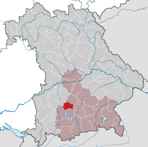
| Location of the Fürstenfeldbruck district in Bavaria | |
  |
|

The district of Fürstenfeldbruck is located in the west of the Bavarian administrative district of Upper Bavaria . The administrative seat is the city of Fürstenfeldbruck .
geography
structure
The Fürstenfeldbruck district can be geologically divided into four areas. In the east and south-east there is flat land with barren fields on the Munich gravel plain . In the far south, south of Moorenweis and Jesenwang, there is a young moraine landscape characterized by mixed forests and meadows, which during the Worm Ice Age between 100,000 BC. BC and 75,000 BC BC originated. To the north of it, most of the district up to about the height of Unterschweinbach is characterized by hilly old moraine land with fertile fields. This moraine landscape was formed during the Riss Ice Age between approx. 270,000 BC. BC and 150,000 BC So-called dead ice holes formed on the terminal moraines. These are lakes that have silted up into moors over time. An example of such a dead ice hole in the district is the Haspelmoor . In the far north, finally, from a line from Tegernbach near Mittelstetten , Unterschweinbach and Überacker , there is only slightly undulating hill country with loamy-sandy soil. Coniferous forests and deep fields predominate here.
Rivers
The Amper flows through the district from south to northeast . Roughly parallel to it, but further north, the smaller Maisach flows .
expansion
The longest north-south extension is 25 kilometers, the longest east-west extension 34 kilometers.
Highest and lowest point
The Steingassenberg northwest of Türkenfeld is the highest point at 624 meters above sea level, according to the district's official website. According to information in a prospectus of the district that is no longer available online, the highest elevation is in the municipality of Kottgeisering . The Geoportal Bayern shows 630.5 meters on Steingassenberg near Türkenfeld and 625 meters in Schönwald northwest of Kottgeisering. The lowest point in the district is 493 meters in the Ampertal near Geiselbullach, municipality of Olching.
Neighboring areas
The district borders in a clockwise direction in the northwest on the district of Dachau , the state capital Munich and the districts of Munich , Starnberg , Landsberg am Lech and Aichach-Friedberg .
history
district Court
The area of today's Fürstenfeldbruck district has long been part of Bavaria. At the beginning of the 19th century, the two district courts of Dachau and Kranzberg were established. The independent regional court of Bruck was formed from parts of these two regional courts in 1823 . It belonged to the Isar district and from 1838 to Upper Bavaria .
District Office
The district office in 1862 Bruck followed the same area district court order of older Bruck.
On August 6, 1908, the Bruck District Office was officially renamed the Fürstenfeldbruck District Office .
district
On January 1, 1939, the designation district was introduced as everywhere else in the German Reich . The district office became Fürstenfeldbruck.
On August 1, 1952, the district of Gröbenzell was reclassified from the city of Munich to the district of Fürstenfeldbruck and merged with parts of three other communities to form the new community of Gröbenzell .
In the course of territorial reform , the Fürstenfeldbruck district handed over several communities to neighboring districts on July 1, 1972:
- The Ebertshausen community moved to the Dachau district.
- The communities Geltendorf and Hausen bei Geltendorf moved to the Landsberg am Lech district.
- The communities of Baierberg , Eresried , Hausen bei Hofhegnenberg , Hofhegnenberg and Steindorf changed to the district of Aichach-Friedberg, which was initially called the district of Augsburg-Ost until May 1, 1973 .
Population development
The Fürstenfeldbruck district gained almost 27,000 inhabitants between 1988 and 2008, or grew by around 15%. Between 1988 and 2018 the district grew from 175,037 to 219,320 by 44,283 inhabitants or by 25.3%.
The east of the district has an urban character due to its proximity to Munich, the west is more rural.
The population figures from 1840 onwards refer to the territorial status on May 25, 1987.
| year | 1840 | 1871 | 1900 | 1925 | 1939 | 1950 | 1961 | 1970 | 1987 | 1991 | 1995 | 2000 | 2005 | 2010 | 2015 |
| population | 15,231 | 19,072 | 23,065 | 30,263 | 41,578 | 66.151 | 82,690 | 118,623 | 172.760 | 182,957 | 186,235 | 193.092 | 199,783 | 204,538 | 213,481 |
politics
District administrators
- May 25, 1945 - June 5, 1946: Hans Miller (acting)
- June 6, 1946 - March 6, 1947: Hans Wachter ( CSU )
- March 13, 1947 - December 2, 1947: Ernst Raadts ( BP )
- December 9, 1947 - May 30, 1948: Karl Huber (CSU)
- June 1, 1948 - April 30, 1964: Ernst Raadts (BP)
- May 1, 1964 - December 31, 1971: Mathias Duschl ( SPD )
- January 1, 1972 - June 30, 1972: Josef Reithmayr (FW), acting
- July 1, 1972 - April 30, 1990: Gottfried Grimm (then CSU)
- May 1, 1990 - April 30, 1996: Rosemarie Grützner ( SPD )
- Since May 1, 1996: Thomas Karmasin (CSU)
District council
| Party / list | 2020 election | Election 2014 | 2008 election |
|---|---|---|---|
| CSU | 26th | 31 | 31 |
| SPD | 7th | 13 | 14th |
| GREEN | 17th | 10 | 10 |
| FW and independent voter community e. V. | 8th | 8th | 7th |
| FDP | 2 | 2 | 4th |
| Independent citizen associations | 3 | 4th | 3 |
| ÖDP / party-free citizens | 3 | 2 | 1 |
| AfD | 3 | ||
| left | 1 | ||
| total | 70 | 70 | 70 |
coat of arms
|
|
Blazon : “By a slanting beam made of silver and red in two rows, divided by green and blue; above a silver prince's crown, below a three-arched brick silver bridge. " |
|
Foundation of the coat of arms: The inclined beam comes from the family coat of arms of the monastery founder St. Bernhard. The prince's crown symbolizes the Wittelsbachers who were also involved in the founding , while the bridge represents Markt Bruck.
The design of the coat of arms goes back to the market coat of arms that was valid until 1936 and was officially introduced on June 30, 1967 by a district council resolution. |
District partnerships
There is an official partnership with the current district of Greiz in Thuringia. This partnership was concluded in 1991 with the then still independent district of Zeulenroda . In the course of the regional reform of 1994, the districts of Greiz, Zeulenroda and parts of the districts of Gera ( district of Gera ) and Schmölln ( district of Schmölln ) were merged.
Economy and Infrastructure
The district is clearly divided into two parts , both economically and in terms of population density . While a large number of medium-sized industries are located in the densely populated east , the less populated west is dominated by agricultural businesses.
In the Future Atlas 2016 , the district was ranked 49th out of 402 districts, municipal associations and urban districts in Germany, making it one of the regions with "high future prospects". In the 2019 edition, it was ranked 72nd out of 401.
traffic
Road traffic
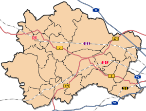

The main roads in the district are the motorways 8 (Munich – Stuttgart) and 99 with the “ Eschenrieder Spange ” in the northeast and east and the A 96 Munich – Lindau in the southeast; additionally the federal highways 2 and 471 .
Rail transport
The district is crossed by two main railway lines:
The Munich-Augsburg Railway Company already took 1839/40 operating on the Munich-Augsburg Railway on. Special tracks for the S-Bahn line 3 run parallel to the Mammendorf station (formerly Nannhofen) , with the S-Bahn stations in Eching, Olching and Gröbenzell in the district.
The Munich – Buchloe line, which was opened by the Bavarian State Railway in 1873 , is also used by the S-Bahn (S 4) to Geltendorf , with S-Bahn stations in Türkenfeld , Grafrath , Schöngeising , Buchenau , Fürstenfeldbruck , Eichenau , Puchheim .
The Pasing – Herrsching railway line , built in 1903, is now used exclusively for traffic on S-Bahn line 8; it only opens up the large district town of Germering in the district .
Bus transport
The MVV operates four types of regional buses in the district:
- Express bus lines (X80, X845, X900, X910, X920): Tangential connections of the S-Bahn lines
- Regional bus routes (803- 889): regional bus services
- Night bus routes N80 and N81: night connections to the city of Munich
- RufTaxilinien: Supplement to regional bus services at times without regular public transport
Communities
(Residents on December 31, 2019)
Other communities
|
 
|
Municipalities of the district before the territorial reform 1971/78
Until the territorial reform in 1971/78, the Fürstenfeldbruck district had 59 municipalities (see list below).
In the northwest the district bordered on the Friedberg district , in the northeast on the Dachau district , in the east on the district and the city of Munich , in the south on the Starnberg district and in the southwest and west on the Landsberg am Lech district .
The municipalities of the Fürstenfeldbruck district before the municipality reform in 1971/78 (municipalities that still exist today are written in bold ):

| former parish | today's parish | today's district |
|---|---|---|
| Adelshofen | Adelshofen | Fürstenfeldbruck |
| Aich | Fürstenfeldbruck | Fürstenfeldbruck |
| Alling | Alling | Fürstenfeldbruck |
| Althegnenberg | Althegnenberg | Fürstenfeldbruck |
| Aufkirchen | Egenhofen | Fürstenfeldbruck |
| Baierberg | Mering | Aichach-Friedberg |
| Biburg | Alling | Fürstenfeldbruck |
| Dünzelbach | Moorenweis | Fürstenfeldbruck |
| Ebertshausen | Odelzhausen | Dachau |
| Egenhofen | Egenhofen | Fürstenfeldbruck |
| Eichenau (independent municipality since 1957) | Eichenau | Fürstenfeldbruck |
| Eismerszell | Moorenweis | Fürstenfeldbruck |
| Emmering | Emmering | Fürstenfeldbruck |
| Eresried | Steindorf | Aichach-Friedberg |
| Esting | Olching | Fürstenfeldbruck |
| Fürstenfeldbruck (city) | Fürstenfeldbruck | Fürstenfeldbruck |
| Geiselbullach | Olching | Fürstenfeldbruck |
| Geltendorf | Geltendorf | Landsberg am Lech |
| Germering | Germering | Fürstenfeldbruck |
| Germerswang | Maisach | Fürstenfeldbruck |
| Gröbenzell (independent municipality since 1952) | Groebenzell | Fürstenfeldbruck |
| Grunertshofen | Moorenweis | Fürstenfeldbruck |
| Gunzlhofen | Oberschweinbach | Fürstenfeldbruck |
| Hattenhofen | Hattenhofen | Fürstenfeldbruck |
| Hausen near Geltendorf | Geltendorf | Landsberg am Lech |
| Hausen near Hofhegnenberg | Steindorf | Aichach-Friedberg |
| Hörbach | Althegnenberg | Fürstenfeldbruck |
| Hofhegnenberg | Steindorf | Aichach-Friedberg |
| Holzhausen | Alling | Fürstenfeldbruck |
| Jesenwang | Jesenwang | Fürstenfeldbruck |
| Kottgeisering | Kottgeisering | Fürstenfeldbruck |
| Landsberied | Landsberied | Fürstenfeldbruck |
| Luttenwang | Adelshofen | Fürstenfeldbruck |
| Maisach | Maisach | Fürstenfeldbruck |
| Malching | Maisach | Fürstenfeldbruck |
| Mammendorf | Mammendorf | Fürstenfeldbruck |
| Mittelstetten | Mittelstetten | Fürstenfeldbruck |
| Moorenweis | Moorenweis | Fürstenfeldbruck |
| Nannhofen | Mammendorf | Fürstenfeldbruck |
| Oberschweinbach | Oberschweinbach | Fürstenfeldbruck |
| Oberweikertshofen | Egenhofen | Fürstenfeldbruck |
| Olching | Olching | Fürstenfeldbruck |
| Pfaffenhofen | Jesenwang | Fürstenfeldbruck |
| Puch | Fürstenfeldbruck | Fürstenfeldbruck |
| Puchheim | Puchheim | Fürstenfeldbruck |
| Purk | Moorenweis | Fürstenfeldbruck |
| Rottbach | Maisach | Fürstenfeldbruck |
| Schöngeising | Schöngeising | Fürstenfeldbruck |
| Steinbach | Moorenweis | Fürstenfeldbruck |
| Steindorf | Steindorf | Aichach-Friedberg |
| Tegernbach | Mittelstetten | Fürstenfeldbruck |
| Turk field | Turk field | Fürstenfeldbruck |
| Überacker | Maisach | Fürstenfeldbruck |
| Unteralting | Grafrath | Fürstenfeldbruck |
| Unterpfaffenhofen | Germering | Fürstenfeldbruck |
| Unterschweinbach | Egenhofen | Fürstenfeldbruck |
| Little Munich | Egenhofen | Fürstenfeldbruck |
| Wildenroth | Grafrath | Fürstenfeldbruck |
| Zankenhausen | Turk field | Fürstenfeldbruck |
Attractions
In addition to the monuments and sights of the individual communities, the Jexhof Farm Museum is worth mentioning.
Protected areas
There are three nature reserves , 13 landscape protection areas , five FFH areas and at least six designated geotopes in the district (as of April 2016).
See also
- List of nature reserves in the Fürstenfeldbruck district
- List of landscape protection areas in the Fürstenfeldbruck district
- List of FFH areas in the Fürstenfeldbruck district
- List of geotopes in the Fürstenfeldbruck district
License Plate
On July 1, 1956, the district was assigned the FFB distinctive sign when the license plates that are still valid today were introduced . It is still issued today.
literature
- District Office Fürstenfeldbruck (ed.): The district of Fürstenfeldbruck - nature, history, culture . Self-published by the District Office, Fürstenfeldbruck 1992, ISBN 3-9803189-0-7
Web links
- Official website of the district
- Literature from and about the Fürstenfeldbruck district in the catalog of the German National Library
- Entry on the coat of arms of the Fürstenfeldbruck district in the database of the House of Bavarian History
Individual evidence
- ↑ "Data 2" sheet, Statistical Report A1200C 202041 Population of the municipalities, districts and administrative districts 1st quarter 2020 (population based on the 2011 census) ( help ).
- ↑ District Office Fürstenfeldbruck: District Administrator. Retrieved April 25, 2020 .
- ↑ The Fürstenfeldbruck district introduces itself ( Memento of the original from May 27, 2015 in the Internet Archive ) Info: The archive link has been inserted automatically and has not yet been checked. Please check the original and archive link according to the instructions and then remove this notice. , visited on May 27, 2015
- ↑ Measured in Geoportal Bayern, Zoom 12, North 48.1132, East 11.0713 or North 48.1244, East 11.1076 , accessed on January 14, 2019
- ^ Wilhelm Volkert (ed.): Handbook of Bavarian offices, communities and courts 1799–1980 . CH Beck, Munich 1983, ISBN 3-406-09669-7 , p. 466 .
- ^ Wilhelm Volkert (ed.): Handbook of Bavarian offices, communities and courts 1799–1980 . CH Beck, Munich 1983, ISBN 3-406-09669-7 , p. 97 .
- ^ Ordinance on the reorganization of Bavaria into rural districts and independent cities of December 27, 1971
- ↑ Statistics for the district , accessed on January 7, 2011
- ↑ Entry on the coat of arms of the Fürstenfeldbruck district in the database of the House of Bavarian History , accessed on September 5, 2017 .
- ↑ Future Atlas 2016. (No longer available online.) Archived from the original on October 2, 2017 ; accessed on March 23, 2018 . Info: The archive link was inserted automatically and has not yet been checked. Please check the original and archive link according to the instructions and then remove this notice.
- ↑ Future Atlas 2019 | Handelsblatt. Retrieved December 10, 2019 .
- ↑ "Data 2" sheet, Statistical Report A1200C 202041 Population of the municipalities, districts and administrative districts 1st quarter 2020 (population based on the 2011 census) ( help ).
- ^ Michael Rademacher: German administrative history from the unification of the empire in 1871 to the reunification in 1990. Fürstenfeldbruck district. (Online material for the dissertation, Osnabrück 2006).
- ↑ BayernViewer of the Bavarian Surveying Administration (accessed on July 20, 2010)
Districts:
Aichach-Friedberg |
Altötting |
Amberg-Sulzbach |
Ansbach |
Aschaffenburg |
Augsburg |
Bad Kissingen |
Bad Toelz-Wolfratshausen |
Bamberg |
Bayreuth |
Berchtesgadener Land |
Cham |
Coburg |
Dachau |
Deggendorf |
Dillingen on the Danube |
Dingolfing-Landau |
Danube Ries |
Ebersberg |
Eichstätt |
Erding |
Erlangen-Höchstadt |
Forchheim |
Freising |
Freyung-Grafenau |
Fürstenfeldbruck |
Fürth |
Garmisch-Partenkirchen |
Gunzburg |
Hatred Mountains |
Yard |
Kelheim |
Kitzingen |
Kronach |
Kulmbach |
Landsberg am Lech |
Landshut |
Lichtenfels |
Lindau (Lake Constance) |
Main-Spessart |
Miesbach |
Miltenberg |
Mühldorf am Inn |
Munich |
Neuburg-Schrobenhausen |
Neumarkt in the Upper Palatinate |
Neustadt an der Aisch-Bad Windsheim |
Neustadt an der Waldnaab |
Neu-Ulm |
Nuremberg Country |
Oberallgäu |
Ostallgäu |
Passau |
Pfaffenhofen an der Ilm |
Rain |
Regensburg |
Rhön-Grabfeld |
Rosenheim |
Roth |
Rottal-Inn |
Schwandorf |
Schweinfurt |
Starnberg |
Straubing Arch |
Tirschenreuth |
Traunstein |
Unterallgäu |
Weilheim-Schongau |
Weißenburg-Gunzenhausen |
Wunsiedel in the Fichtel Mountains |
Wurzburg
Independent cities:
Amberg |
Ansbach |
Aschaffenburg |
Augsburg |
Bamberg |
Bayreuth |
Coburg |
Erlangen |
Fürth |
Hof (Saale) |
Ingolstadt |
Kaufbeuren |
Kempten (Allgäu) |
Landshut |
Memmingen |
Munich |
Nuremberg |
Passau |
Regensburg |
Rosenheim |
Schwabach |
Schweinfurt |
Straubing |
Willows in the Upper Palatinate |
Wurzburg