
District of Neu-Ulm
| coat of arms | Germany map |
|---|---|

|

Coordinates: 48 ° 18 ' N , 10 ° 8' E |
| Basic data | |
| State : | Bavaria |
| Administrative region : | Swabia |
| Administrative headquarters : | New Ulm |
| Area : | 515.86 km 2 |
| Residents: | 175,204 (Dec. 31, 2019) |
| Population density : | 340 inhabitants per km 2 |
| License plate : | NU, ILL |
| Circle key : | 09 7 75 |
| NUTS : | DE279 |
| Circle structure: | 17 municipalities |
| Address of the district administration: |
Kantstrasse 8 89231 Neu-Ulm |
| Website : | |
| District Administrator : | Thorsten Freudenberger ( CSU ) |
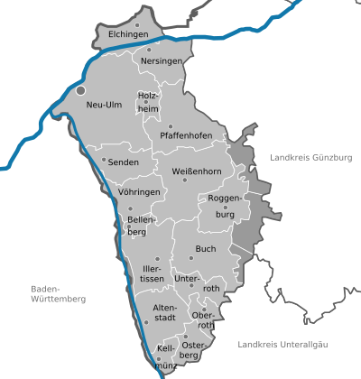
| Location of the district of Neu-Ulm in Bavaria | |
  |
|

The district of Neu-Ulm is located in the west of the Bavarian administrative district of Swabia . It is part of the Danube-Iller region . The seat of the district office is in Neu-Ulm .
geography
location
The district extends largely in the Alpine foothills east of the Iller south of the Danube , only the municipality of Elchingen lies north on the edge of the Swabian Alb . The district area extends over the so-called "Iller-Lech-Platte", a gravel area that slopes down to the Iller in the west and to the Danube in the north. In the south, the district rises to heights of up to 610 m.
Neighboring areas
The district borders in a clockwise direction in the northeast on the districts of Günzburg and Unterallgäu (both in Bavaria) as well as on the district of Biberach , the Alb-Danube district and the urban district of Ulm (all in Baden-Württemberg ).
history
Regional courts
In 1804 the district courts Illertissen and Roggenburg were established. They belonged to the Illerkreis of the Kingdom of Bavaria , from 1817 to the Oberdonaukreis , which was renamed Swabia and Neuburg in 1838 , later Swabia. In 1842 the Neu-Ulm Regional Court was established from parts of the Günzburg Regional Court and a municipality from the Illertissen Regional Court. In 1852 the Babenhausen district court was established from the court of the same name.
District Offices
In 1862 the three district courts Illertissen, Roggenburg and Babenhausen formed the district office Illertissen, whereby the seat of the district court Roggenburg was relocated to Weißenhorn with some municipalities transferred to the district office Krumbach. The district office of the same name was formed from the Neu-Ulm district court in 1862.
On January 1, 1880, areas in the Weißenhorn area of the Illertissen district office were assigned to the Neu-Ulm district office. Illertissen also gave some places to the Krumbach and Memmingen district offices .
On March 1, 1891, the city of Neu-Ulm left the district office and became a city directly within the district .
On January 1, 1908, the district office ceded the Offenhausen community to the city of Neu-Ulm.
Counties
On January 1, 1939, the designation district was introduced as everywhere else in the German Reich . The district offices became the districts of Illertissen and Neu-Ulm. District Administrator Friedrich Schreck experienced the transition in Neu-Ulm . On April 1, 1940, the city of Neu-Ulm was incorporated into the Neu-Ulm district, but this was reversed on April 1, 1948.
District of Neu-Ulm
As part of the regional reform in Bavaria , the district of Neu-Ulm, the majority of the district of Illertissen and the independent city of Neu-Ulm were merged to form a new district on July 1, 1972 . This was initially called Illerkreis , like the historical administrative district of the Kingdom of Bavaria, but covered a different area. The southern communities of the Illertissen district around Babenhausen were assigned to the Unterallgäu district. On May 1, 1973, the new Illerkreis was renamed the Neu-Ulm district . The city of Neu-Ulm received the status of a large district town for the loss of district freedom .
On January 1, 1978, the communities Ettlishofen and Silheim moved from the Neu-Ulm district to the Günzburg district, where they were incorporated into the Bibertal community . On the same day, the communities of Bebenhausen and Kettershausen also moved from the Neu-Ulm district to the Unterallgäu district.
With a resolution of July 26, 2017, the city council of Neu-Ulm initiated the withdrawal of the city from the district and thus the restoration of the freedom of the district. This process was already referred to in the media as nuxit in advance , based on the word creations Grexit and Brexit .
Population development
The district of Neu-Ulm gained over 22,000 inhabitants between 1988 and 2008 or grew by around 16%. Between 1988 and 2018 the district grew from 142,438 to 174,200 by 31,762 inhabitants or 22.3%.
The following figures refer to the territorial status on May 25, 1987.
| Population development | ||||||||||||||
|---|---|---|---|---|---|---|---|---|---|---|---|---|---|---|
| year | 1840 | 1900 | 1939 | 1950 | 1961 | 1970 | 1987 | 1991 | 1995 | 2000 | 2005 | 2010 | 2015 | |
| Residents | 29,083 | 40,821 | 56,988 | 86,538 | 104.023 | 125.054 | 140,666 | 150.091 | 157.240 | 159,670 | 163,387 | 165.461 | 170,309 | |
politics
District Administrator
- 1946–1948: Ferdinand Siebert ( CSU ), later Free Voters' Association
- 1948–1964: Georg Köhl (CSU)
- 1964–1973: Max Rauth ( SPD )
- 1974–1996: Franz-Josef Schick (CSU)
- 1996-2014: Erich Josef Geßner (CSU)
- since May 1, 2014: Thorsten Freudenberger (CSU)
On March 16, 2014, the senior student councilor Thorsten Freudenberger (CSU) was elected as Erich Josef Gessner's successor with 58.5% in the course of the regular Bavarian municipal elections. His term of office began on May 1, 2014.
District council
The district council consists of 70 members who are divided between the following parties and constituencies:
| CSU | SPD | FW | GREEN | FDP | ödp / CFU | Young Union | left | total | |
| 2002 | 36 | 18th | 8th | 5 | 2 | 1 | - | - | 70 seats |
| 2008 | 34 | 15th | 11 | 8th | 2 | - | - | - | 70 seats |
| 2014 | 32 | 14th | 13 | 9 | 2 | - | - | - | 70 seats |
| 2020 | 27 | 7th | 14th | 13 | 2 | 3 | 3 | 1 | 70 seats |
| District election in percent |
CSU | FW | Green | SPD | ÖDP | JU | FDP | left | voter turnout |
|---|---|---|---|---|---|---|---|---|---|
| 2020 | 38.7% | 19.4% | 18.1% | 10.7% | 4.0% | 3.6% | 3.6% | 1.9% | 47.1% |
| 2014 | 46.2% | 18.2% | 12.5% | 20.4% | - | - | 2.9% | - | 46.6% |
coat of arms
|
|
Blazon : "Above a red shield base, inside a horizontal, gold-studded, silver horn, divided five times to the left diagonally by red and silver, covered with a black-clad and gold-crowned moor growing out of the dividing line, who holds a golden bishop's cap in her hands." |
| Justification of the coat of arms: The three parts of the coat of arms represent the count families who ruled over significant parts of today's district in the Middle Ages. The Mohrin is reminiscent of the Counts of Kirchberg. Some places in the Illertal were subordinate to them. The red diagonal bars stand for the Counts of Berg , who ruled in the eastern part of the district (around Pfaffenhofen). The Hifthorn is reminiscent of the Lords of Neuffen , to whom Weißenhorn and Buch were subordinate. The coat of arms figure here has black skin color. |
District partnerships
The district maintains partnerships with the market town of Prad am Stilfserjoch in Italy and the district of Mansfelder Land in Saxony-Anhalt .
Economy and Infrastructure
traffic
rail
As early as 1853, the district town was the terminus of the route from Augsburg opened by the Bavarian State Railways , which was extended over the Danube to Ulm the following year . The next train station with an hourly ICE stop is Ulm Hauptbahnhof . An ICE has also stopped in Neu-Ulm since the end of 2017.
In 1862 the Illertalbahn was added to Memmingen , which leads south from Neu-Ulm via Illertissen and Kellmünz. Two local railway lines of the Bavarian State Railway branched off from it, from 1878 the line Senden – Weißenhorn and from 1894 the line Kellmünz – Babenhausen . The two local railways were closed for passenger traffic after the Second World War. In 1964 the line from Kellmünz to Babenhausen lost its passenger traffic, in 1966 the line from Senden to Weißenhorn . While the Babenhausen line also lost freight traffic in the 1990s and was then shut down and dismantled, the Weißenhorn Railway kept its freight traffic. On December 15, 2013 it was reactivated for passenger traffic, since then direct trains have been running every hour between Weißenhorn and Ulm.
The municipality of Elchingen is located on the Brenz Railway from Ulm to Aalen, which opened north of the Danube in 1876 . From 1897 to 1945 Neu-Ulm was connected to the neighboring city of Ulm by an electric tram .
Street
The district is framed by the A 8 to the north and the A 7 to the west . Thus there is a good motorway connection in the whole district.
Bicycle traffic
The signposted Iller cycle path as a tourist offer for cyclists runs through the district on the western edge from south to north. The Danube Cycle Path runs as a European long-distance cycle path in the north of the district.
economy
In the Future Atlas 2016 , the Neu-Ulm district was ranked 84th out of 402 districts, municipal associations and urban districts in Germany, making it one of the places with "high future opportunities". In the 2019 edition, it was ranked 125th out of 401.
While the southern district of Neu-Ulm has a more rural structure, in the north and along the Iller to Illertissen there is a large number of companies, some of which operate internationally. The largest employers in the district are Wieland-Werke AG in Vöhringen, EvoBus GmbH , which belongs to Daimler AG, in Neu-Ulm and Bosch Rexroth in Elchingen. The world market leader in building formwork and scaffolding, Peri GmbH in Weißenhorn, is also worth mentioning . Due to the proximity to the Elchinger Kreuz, where the A7 and A8 motorways intersect, the Neu-Ulm area is the center for logistics and forwarding. According to its own statement, the largest furniture store in Europe, Inhofer, is located in Senden / Iller.
In the center of the southern district, Illertissen , the pharmaceutical company Pfizer and the specialty chemicals manufacturer BASF Personal Care and Nutrition GmbH are the largest employers.
In recent years there has been increasing attempt to promote the catering and accommodation industry, which is favored by its proximity to tourist attractions (e.g. Legoland Günzburg, city of Ulm, tourist regions Allgäu and Lake Constance).
In October 2018, the unemployment rate in the Neu-Ulm district was 1.9%.
Communities

(Residents on December 31, 2019)
Other communities
|
  |
|
Unregulated areas (44.61 km²)
|
Municipalities of the district before the territorial reform 1971/78


Before the regional reform, the Neu-Ulm district had 54 communities. Until 1908, the district called Neu-Ulm District Office at that time had one more municipality. At the beginning of this year Offenhausen was incorporated into the city of Neu-Ulm.
In the northeast the district bordered on the district of Günzburg , in the southeast on the district of Krumbach , in the south on the district of Illertissen in the west and north on the Baden-Württemberg district of Ulm and in the northwest on the independent cities of Neu-Ulm and Ulm .
In the case of the parishes that were dissolved, it is noted in brackets to which parish the place belongs today. The churches that still exist today are in bold .
Other communities
- Attenhofen ( Weißenhorn )
- Up ( send )
- Ay an der Iller ( sending )
- Balmertshofen ( Pfaffenhofen adRoth )
- Berg ( Pfaffenhofen adRoth )
- Beuren ( Pfaffenhofen adRoth )
- Biberach ( Roggenburg )
- Biberachzell ( Weißenhorn )
- Biberberg ( Pfaffenhofen adRoth )
- Bubenhausen ( Weißenhorn )
- Burlafingen ( Neu-Ulm )
- Emershofen ( Weißenhorn )
- Erbishofen ( Pfaffenhofen adRoth )
- Ettlishofen ( Bibertal in the district of Günzburg )
- Finningen ( Neu-Ulm )
- Gerlenhofen ( New Ulm )
- Grafertshofen ( Weißenhorn )
- Hausen ( Neu-Ulm )
- Hegelhofen ( Weißenhorn )
- Hittistetten ( sending )
- Holzheim
- Holzschwang ( Neu-Ulm )
- Illerberg ( Voehringen )
- Illerzell ( Voehringen )
- Ingstetten ( Roggenburg )
- Kadeltshofen ( Pfaffenhofen adRoth )
- Leibi ( Nersingen )
- Meßhofen ( Roggenburg )
- Nersingen
- Neuhausen ( Holzheim )
- Niederhausen ( Pfaffenhofen adRoth )
- Oberelchingen ( Elchingen )
- Oberfahlheim ( Nersingen )
- Oberhausen ( Weissenhorn )
- Oberreichenbach ( Weißenhorn )
- Pfuhl ( Neu-Ulm )
- Raunertshofen ( Pfaffenhofen adRoth )
- Reutti ( Neu-Ulm )
- Roth ( Pfaffenhofen adRoth )
- Shooting ( Roggenburg )
- Silheim ( Bibertal in the district of Günzburg )
- Steinheim ( Neu-Ulm )
- Straß ( Nersingen )
- Thal ( Voehringen )
- Thalfingen ( Elchingen )
- Unterelchingen ( Elchingen )
- Unterfahlheim ( Nersingen )
- Volkertshofen ( Pfaffenhofen adRoth )
- Wallenhausen ( Weißenhorn )
- Witzighausen ( sending )
- Wullenstetten ( sending )
- Oberroggenburger Wald (6.43 km²; still exists today)
- Stoffenrieder Forest (15.79 km²; still exists today)
- Unterroggenburger Wald (17.62 km²; still exists today)
Protected areas
There are four nature reserves , seven landscape protection areas , four FFH areas and at least three geotopes designated by the Bavarian State Office for the Environment (as of May 2016) in the district.
See also:
- List of nature reserves in the Neu-Ulm district
- List of landscape protection areas in the Neu-Ulm district
- List of FFH areas in the Neu-Ulm district
- List of geotopes in the Neu-Ulm district
License Plate
On July 1, 1956, the district was assigned the distinguishing mark NU when the vehicle registration number that is still valid today was introduced . It is still issued today.
Until the 1990s, vehicles from the old district of Illertissen received license plates with the letter pairs AA to ZZ and the numbers from 100 to 999.
Since 10 July 2013, in connection with the license plate liberalization also the distinguishing sign ILL (Illertissen) available.
literature
- Anton H. Konrad : Between Alb and Allgäu - The district of Neu-Ulm . Anton H. Konrad Verlag, Weißenhorn 2002, ISBN 3-87437-459-9 .
- Various authors (the entire editing was done in cooperation with the Neu-Ulm district): Neu-Ulm district . Kunstverlag Josef Bühn, Munich 1985.
Web links
- Official website of the district
- Literature from and about the district of Neu-Ulm in the catalog of the German National Library
- Entry on the coat of arms of the Neu-Ulm district in the database of the House of Bavarian History
Individual evidence
- ↑ "Data 2" sheet, Statistical Report A1200C 202041 Population of the municipalities, districts and administrative districts 1st quarter 2020 (population based on the 2011 census) ( help ).
- ^ Wilhelm Volkert (ed.): Handbook of Bavarian offices, communities and courts 1799–1980 . CH Beck, Munich 1983, ISBN 3-406-09669-7 , p. 97 .
- ^ Ordinance on the reorganization of Bavaria into rural districts and independent cities of December 27, 1971
- ^ Federal Statistical Office (ed.): Historical municipality directory for the Federal Republic of Germany. Name, border and key number changes in municipalities, counties and administrative districts from May 27, 1970 to December 31, 1982 . W. Kohlhammer, Stuttgart / Mainz 1983, ISBN 3-17-003263-1 , p. 790 .
- ↑ BR-Online: Neu-Ulm wants "Nuxit" ( Memento from July 4, 2018 in the Internet Archive ) (July 26, 2017)
- ↑ https://www.merkur.de/bayern/kommunalwahl-bayern-2020-gemeinderatswahlen-gemeinden-results-13595423.html
- ↑ Thorsten Freudenberger becomes the new district administrator of the Neu-Ulm district. Neu-Ulm district, March 18, 2014, accessed on March 18, 2014 .
- ↑ Local elections in Bavaria on March 16, 2014. Election of the city councils in the independent cities. Election of the district councils, preliminary results. Neu-Ulm district, March 17, 2014, accessed on March 18, 2014 .
- ↑ Entry on the coat of arms of the Neu-Ulm district in the database of the House of Bavarian History , accessed on September 5, 2017 .
- ↑ Future Atlas 2016. (No longer available online.) Archived from the original on October 2, 2017 ; accessed on March 23, 2018 . Info: The archive link was inserted automatically and has not yet been checked. Please check the original and archive link according to the instructions and then remove this notice.
- ↑ PROGNOS future atlas. Handelsblatt, accessed on December 10, 2019 .
- ↑ "Data 2" sheet, Statistical Report A1200C 202041 Population of the municipalities, districts and administrative districts 1st quarter 2020 (population based on the 2011 census) ( help ).
- ^ Michael Rademacher: German administrative history from the unification of the empire in 1871 to the reunification in 1990. Neu-Ulm district. (Online material for the dissertation, Osnabrück 2006).
- ↑ a b page on the Neu-Ulm district at gemeindeververzeichnis.de - accessed on February 28, 2010
Districts:
Aichach-Friedberg |
Altötting |
Amberg-Sulzbach |
Ansbach |
Aschaffenburg |
Augsburg |
Bad Kissingen |
Bad Toelz-Wolfratshausen |
Bamberg |
Bayreuth |
Berchtesgadener Land |
Cham |
Coburg |
Dachau |
Deggendorf |
Dillingen on the Danube |
Dingolfing-Landau |
Danube Ries |
Ebersberg |
Eichstätt |
Erding |
Erlangen-Höchstadt |
Forchheim |
Freising |
Freyung-Grafenau |
Fürstenfeldbruck |
Fürth |
Garmisch-Partenkirchen |
Gunzburg |
Hatred Mountains |
Yard |
Kelheim |
Kitzingen |
Kronach |
Kulmbach |
Landsberg am Lech |
Landshut |
Lichtenfels |
Lindau (Lake Constance) |
Main-Spessart |
Miesbach |
Miltenberg |
Mühldorf am Inn |
Munich |
Neuburg-Schrobenhausen |
Neumarkt in the Upper Palatinate |
Neustadt an der Aisch-Bad Windsheim |
Neustadt an der Waldnaab |
Neu-Ulm |
Nuremberg Country |
Oberallgäu |
Ostallgäu |
Passau |
Pfaffenhofen an der Ilm |
Rain |
Regensburg |
Rhön-Grabfeld |
Rosenheim |
Roth |
Rottal-Inn |
Schwandorf |
Schweinfurt |
Starnberg |
Straubing Arch |
Tirschenreuth |
Traunstein |
Unterallgäu |
Weilheim-Schongau |
Weißenburg-Gunzenhausen |
Wunsiedel in the Fichtel Mountains |
Wurzburg
Independent cities:
Amberg |
Ansbach |
Aschaffenburg |
Augsburg |
Bamberg |
Bayreuth |
Coburg |
Erlangen |
Fürth |
Hof (Saale) |
Ingolstadt |
Kaufbeuren |
Kempten (Allgäu) |
Landshut |
Memmingen |
Munich |
Nuremberg |
Passau |
Regensburg |
Rosenheim |
Schwabach |
Schweinfurt |
Straubing |
Willows in the Upper Palatinate |
Wurzburg