
District of Freising
| coat of arms | Germany map |
|---|---|

|

Coordinates: 48 ° 27 ' N , 11 ° 44' E |
| Basic data | |
| State : | Bavaria |
| Administrative region : | Upper Bavaria |
| Administrative headquarters : | Freising |
| Area : | 799.83 km 2 |
| Residents: | 180.007 (Dec. 31, 2019) |
| Population density : | 225 inhabitants per km 2 |
| License plate : | FS |
| Circle key : | 09 1 78 |
| NUTS : | DE21B |
| Circle structure: | 24 municipalities |
| Address of the district administration: |
Landshuter Strasse 31 85356 Freising |
| Website : | |
| District Administrator : | Helmut Petz ( FW ) |
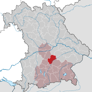
| Location of the Freising district in Bavaria | |
  |
|


The district of Freising is located in the northeast of the Bavarian administrative district of Upper Bavaria and belongs to the Munich region . The proximity to the Bavarian capital Munich as well as the very good transport infrastructure (with the Munich airport located in the district area and the very good local transport connections to Munich as part of the Munich transport association ) make the Freising district one of the most sought-after and fastest-growing business and residential locations in Germany . In the current economic power ranking of the magazine Focus, it ranks 3rd among all German districts, after the neighboring districts of Munich and Pfaffenhofen.
geography
location
The district area essentially comprises two landscapes: In addition to the Danube-Isar hill country in the north and in the middle of the district, which also takes up the far larger portion of the district area, there are still foothills of the Munich gravel plain in the extreme south and on the eastern district border Form of the Freisinger and Erdinger moss. The Isar , Amper and Glonn are the first-order bodies of water that run through the district. While the Isar flows from south-west to north-east, its tributary Amper and its tributary Glonn flow in a west-east direction through the district.
Important places
The largest towns are the large district town of Freising and the municipality of Neufahrn , followed by the city of Moosburg . The oldest town in the district is Moosburg, which received town charter in 1331, before Freising (1359).
Neighboring areas
The district borders clockwise in the north, beginning with the districts of Kelheim , Landshut , Erding , Munich , Dachau and Pfaffenhofen an der Ilm .
history
Regional courts
The district area belonged mainly to Bavaria before 1803 and was assigned to the district courts of Kranzberg and Moosburg . Only the prince-bishopric of Freising with the city of Freising was its own spiritual domain, which was secularized in 1802 and incorporated into the electorate of Bavaria. In 1803 the Moosburg Regional Court was incorporated into the new organization of the state unchanged. At the beginning of 1804 the district court of Kranzberg was dissolved and the one in Freising was rebuilt. The two regional courts of Freising and Moosburg had belonged to the Isar district since 1808 ( Upper Bavaria from 1838 ).
- District judge
- Karl Freiherr von Stromer (from 1804)
- Maximilian von Ockl (from 1805)
- Franz Bernhard Grosch (1817–1849)
- Karl Breidenbach (1849–1862)
District Office
In 1862, both districts of the regional court were merged in administrative terms to form the Freising District Office . The previous district judge Karl Breidenbach was the first district official.
On July 1, 1862, the city of Freising left the district office and became a district direct city .
On January 1, 1905, the Neustift community was incorporated into the city of Freising.
On February 1, 1927, the Freising district office was expanded to include the Pfrombach community of the Erding district office.
district
On January 1, 1939, the designation district was introduced as everywhere else in the German Reich . So the district office became the district of Freising.
On April 1, 1940, Freising was incorporated into the Freising district, but this was reversed on February 8, 1946. As part of the regional reform in Bavaria , the district was enlarged on July 1, 1972. The city of Freising was reintegrated into the district and received the status of a large district town for the loss of district freedom . The communities Au in der Hallertau , Berg , Enzelhausen , Grafendorf , Grünberg , Günzenhausen , Haslach , Osseltshausen , Osterwaal , Rudertshausen and Tegernbach from the disbanded district of Mainburg and the community of Fahrenzhausen in the district of Dachau also joined the district .
On May 1, 1978 the district of Goldach in the municipality of Notzing in the district of Erding was changed to Hallbergmoos in the district of Freising. At the same time, the district gave the municipality of Bruckberg to the district of Landshut.
Covid-19 pandemic
In the Covid 19 pandemic, the district was one of the ten most severely affected districts in Germany at the end of March 2020.
Population development
The district of Freising gained over 43,000 inhabitants from 1988 to 2008 or grew by approx. 35%. In the period mentioned, this is the second highest percentage population increase in a district in Bavaria - after the neighboring district of Erding. Between 1988 and 2018 the district grew from 122,369 to 179,116 by 56,747 inhabitants or 46.4%.
The following population figures refer to the area as of May 25, 1987.
| Population development | ||||||||||||||
|---|---|---|---|---|---|---|---|---|---|---|---|---|---|---|
| year | 1840 | 1900 | 1939 | 1950 | 1961 | 1970 | 1987 | 1991 | 1995 | 2000 | 2005 | 2010 | 2015 | 2016 |
| Residents | 32,763 | 48.212 | 59,250 | 82,737 | 81,374 | 95,153 | 118,518 | 132,536 | 141.022 | 152,307 | 160,655 | 166,375 | 173.225 | 175,803 |
Economy, infrastructure, science
In the Future Atlas 2016 , the Freising district was ranked 442 out of 402 districts, municipal associations and independent cities in Germany, making it one of the regions with "very high future prospects".
Economy and science
In the Freising district there are over 73,000 employees subject to social security contributions in well over 4,000 companies. The unemployment rate was 1.9% (1,959 people) in May 2015 and was one of the lowest in Germany. Munich Airport, located on the district border, is an important economic factor. Despite a rapidly growing "high-tech landscape", the Freising district still has a very good mix of medium-sized companies. Today three quarters of the company's productivity is generated in trade, transport and services, and only one percent in agriculture . In addition, the region is one of the top locations in Germany in the fields of biotechnology and logistics . In the competence field of nutrition and food science or in information and communication technology, there is no need to shy away from comparison with other locations. The district is now growing by around 2,000 people annually. With an average age of 38 years, it has the youngest inhabitants in Bavaria.
The Freising district is the seat of the Weihenstephan Science Center for Nutrition, Land Use and Environment of the Technical University of Munich . It is one of the world's most renowned teaching and research centers in the field of the so-called life sciences, as it covers the entire spectrum of life science research, in particular the food chain from plant and animal breeding to agricultural and forestry sciences to nutritional science and medicine. Around 3,500 students are preparing for their future careers here. What is unique about the Weihenstephan Science Center is the close networking of the research disciplines. The Weihenstephan is located since 1971 at the site Weihenstephan , offering a suite of innovative, green and practical courses.
tourism

main portal ⊙
The Domberg in Freising with the diocesan museum and the old town of Freising are the main attractions. The Kastulusmüster is located in Moosburg on the Isar .
Three long-distance cycle paths lead through the district: the Isar cycle path through the Isarau forest, the 201 km long Ammer-Amper cycle path through the Ampertal and the international long-distance cycle path Munich - Regensburg - Prague along the Isar and through the Hallertau hop-growing area .
The Hallertau, the largest contiguous hop growing area in the world, is partly located in the Freising district; the hop stalks shape the image of the Hallertau.

traffic
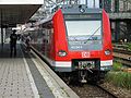
The Freising district has very convenient transport links. It is part of the Munich Transport Association (MVV) and also includes most of Munich Airport , which the Regensburg Airport Express and S-Bahn lines 1 and 8 from Munich connect through the district.
The main line Munich - Regensburg , which was opened by the AG der Bayerische Ostbahnen in 1858, is also used by S-Bahn line 1 to the district town of Freising. Other stops for regional trains are Marzling, Langenbach and Moosburg , all of which are still part of the MVV tariff area.
While the S 1 stops in Eching and Neufahrn and the S 8 stop in Hallbergmoos have had a transfer-free connection to the airport since 1992 and 1998, respectively, after the Neufahrner curve was completed in 2018, a new regional express from Regensburg also made a transfer-free one Connection of the other stops to the airport realized.
The Munich subway line 6 is also worth mentioning because it ends at the district boundary, in the immediate vicinity of the Echingen part of Dietersheim , in the Garching research area and is therefore also integrated into the regional bus network. Furthermore, the Munich-Ingolstadt railway line (with Paindorf train station just 500 m away) just passes the district area.
In the Hallertau , two local railway lines of the Bavarian State Railways were built at the turn of the century : the first was the line from Wolnzach to Mainburg in 1895 and then in 1909 the line branching off via Au and Nandlstadt to Langenbach near Freising in Enzelhausen . Passenger traffic was stopped on these two routes in 1969, but not until 1973 on the Unterzolling – Langenbach section.
The federal highways 9 (Munich-Nuremberg) and 92 (Munich-Deggendorf) as well as the federal highways 11 , 13 and 301 , as well as the state highways 2045, 2053, 2054, 2084, 2085, 2331, 2339, 2341 and 2584 open up the district.
Train

R train

Subway
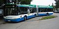
Regional bus


politics
District council
Since the local elections on March 15, 2020 , the seats in the district council of the Freising district have been distributed as follows:
|
Committees
- District Committee
- Youth Welfare Committee
- Committee for Planning, Environment, Tourism, District Development and Infrastructure
- Committee on School, Culture and Sport
- Committee on Demographic and Social Issues
- Audit Committee
Other bodies
- Supervisory board of the Krankenhaus Freising GmbH
- Rescue Association Erding
- Zweckverband Staatl. Neufahrn grammar school
- Supervisory board housing and property company mbH
- Association meeting Sparkasse Freising
- Association meeting Sparkasse Moosburg
District Administrator
- 1946–1966: Philipp Held ( CSU )
- 1966–1996: Ludwig stepsloher (CSU)
- 1996–2008: Manfred Pointner (PFW)
- 2008-2014: Michael Schwaiger (FW)
- 2014–2020: Josef Hauner (CSU)
- since May 1, 2020: Helmut Petz (FW)
coat of arms
|
|
Blazon : “Under the shield head with the Bavarian diamonds split by gold and red; in front a left-turning, red crowned moor's head with a red earring, behind a heraldic silver rose. " |
| Justification of the coat of arms: The coat of arms explains the history of the district area. The diamonds stand for the old ducal offices of Kranzberg and Moosburg . The Mohrenkopf is the coat of arms of the former Hochstift Freising , whose area on the Isar fell to Bavaria in 1802. The image of the Moor is an erroneous reinterpretation of the head of the diocese patron St. Korbinian on pre-Alaldic coins. The rose is a reduction of the heraldic coat of arms of the Count of Moosburg, which died out in 1281, containing three roses . |
Institutions of the district
Clinic
- Klinikum Freising , academic teaching hospital of the Technical University of Munich , operated by Krankenhaus Freising GmbH
Schools (sponsored by the district)
- Special Education Center Freising (special needs school with special focus on learning, language and social-emotional development)
- Camerloher High School , Freising
- Dom-Gymnasium, Freising
- Karl-Ritter-von-Frisch-Gymnasium , Moosburg
- Oskar-Maria-Graf-Gymnasium, Neufahrn (in association with the Neufahrn community )
- Business school, Freising
- Technical college / vocational school, Freising
- State vocational school center, Freising
- Imma-Mack-Realschule, Eching
- Kastulus-Realschule, Moosburg
- Karl Meichelbeck Secondary School
- Good Änger secondary school, Freising
- Realschule Au in the Hallertau
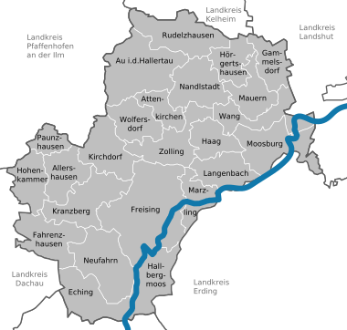
Communities
The largest municipality in the district is the large district town of Freising with 45,118 inhabitants (with secondary residences 48,462), followed by the municipality of Neufahrn bei Freising with 18,973 (21,156) inhabitants and the city of Moosburg an der Isar with 17,487 inhabitants.
(Residents on December 31, 2019)

| city | coat of arms | Area km² |
Resident December 31, 2016 |
PE density PE per km² |
Height above sea level |
|---|---|---|---|---|---|
| Freising , large district town | 88.60 | 49.126 | 554 | 448 | |
| Moosburg adIsar | 43.85 | 18,656 | 425 | 421 |
| market | coat of arms | Area km² |
Resident December 31, 2016 |
PE density PE per km² |
Height above sea level |
|---|---|---|---|---|---|
| Au idHallertau | 54.98 | 6.131 | 112 | 452 | |
| Nandlstadt | 34.30 | 5,306 | 155 | 465 |
| local community | coat of arms | Area km² |
Resident December 31, 2016 |
PE density PE per km² |
Height above sea level |
|---|---|---|---|---|---|
| Allershausen | 26.55 | 5,840 | 220 | 442 | |
| Attenkirchen | 16.11 | 2,817 | 175 | 524 | |
| Eching | 37.31 | 14,015 | 376 | 469 | |
| Fahrenzhausen | 37.64 | 5,026 | 134 | 465 | |
| Gammelsdorf | 21.63 | 1,461 | 68 | 495 | |
| Hague adAmper | 21.71 | 2,965 | 137 | 440 | |
| Hallbergmoos | 35.07 | 11.094 | 316 | 460 | |
| Hohenkammer | 25.74 | 2,634 | 102 | 471 | |
| Hörgertshausen | 21.48 | 1.994 | 93 | 453 | |
| Kirchdorf adAmper | 32.96 | 3,256 | 99 | 440 | |
| Kranzberg | 39.51 | 4.152 | 105 | 483 | |
| Langenbach | 26.89 | 4,040 | 150 | 429 | |
| Marzling | 20.50 | 3.224 | 157 | 443 | |
| Walls | 24.14 | 3.124 | 129 | 435 | |
| Neufahrn near Freising | 45.53 | 20,165 | 443 | 464 | |
| Paunzhausen | 12.72 | 1,515 | 119 | 509 | |
| Rudelzhausen | 40.81 | 3,475 | 85 | 440 | |
| Wang | 31.19 | 2,530 | 81 | 415 | |
| Wolfersdorf | 26.05 | 2,602 | 100 | 502 | |
| Zolling | 34.54 | 4,859 | 141 | 429 |
- Allershausen with the member communities Allershausen and Paunzhausen
- Walls with the member communities Gammelsdorf, Hörgertshausen, Mauern and Wang
- Zolling with the member communities Attenkirchen, Haag adAmper, Wolfersdorf and Zolling
Municipalities of the district before the territorial reform 1971/78
Before the regional reform, the Freising district had 69 municipalities (see list below). The municipality Neustift was in 1905 part of the town of Freising, Vötting in 1937. The community Hagsdorf was after 1935 sweat former village incorporated and the community Johanneck on April 1 of 1939 Paunzhausen .
In the north the district bordered on the district of Mainburg , in the northeast on the district of Landshut , in the southeast on the district of Erding , in the south on the district of Munich , in the south-west on the district of Dachau and in the northwest on the district of Pfaffenhofen adIlm . The city of Freising was not part of the district, but an independent city, but was still the seat of the district administration.
The municipalities of the Freising district before the municipality reform in 1971/78. (Churches that still exist today are written in bold .)
| Former parish | Today's church | Today's district |
|---|---|---|
|
Abens (originated in 1971 from the communities of Hemhausen and Hirnkirchen ; 1978 incorporated into Au idHallertau) |
Au idHallertau | District of Freising |
| Airischwand | Nandlstadt | District of Freising |
| Aiterbach | Allershausen | District of Freising |
| Allershausen | Allershausen | District of Freising |
| Anglberg | Zolling | District of Freising |
| Appersdorf | Zolling | District of Freising |
| Attaching | Freising | District of Freising |
| Attenkirchen | Attenkirchen | District of Freising |
| Baumgarten | Nandlstadt | District of Freising |
| Berghaselbach | Wolfersdorf | District of Freising |
| Bruckberg | Bruckberg | Landshut district |
| Bruckbergerau | Bruckberg | Landshut district |
| Dürnhaindlfing | Wolfersdorf | District of Freising |
| Eching | Eching | District of Freising |
| Enghausen | Walls | District of Freising |
| Figlsdorf | Nandlstadt | District of Freising |
| Gammelsdorf | Gammelsdorf | District of Freising |
| Giggenhausen | Neufahrn near Freising | District of Freising |
| Gremertshausen | Kranzberg | District of Freising |
| Großnöbach | Fahrenzhausen | District of Freising |
| Gunzenhausen | Eching | District of Freising |
| Hague adAmper | Hague adAmper | District of Freising |
| Haindlfing | Freising | District of Freising |
| Hallbergmoos | Hallbergmoos | District of Freising |
| Hemhausen | Au idHallertau | District of Freising |
| Brain churches | Au idHallertau | District of Freising |
| Hohenbercha | Kranzberg | District of Freising |
| Hohenkammer | Hohenkammer | District of Freising |
| Hörgertshausen | Hörgertshausen | District of Freising |
| Ink oven | Hague adAmper | District of Freising |
| Inzkofen | Wang | District of Freising |
| Itzling | Freising | District of Freising |
| Jarzt | Fahrenzhausen | District of Freising |
| Kammerberg | Fahrenzhausen | District of Freising |
| Kirchdorf adAmper | Kirchdorf adAmper | District of Freising |
| Kranzberg | Kranzberg | District of Freising |
| Langenbach | Langenbach | District of Freising |
| Lauterbach | Fahrenzhausen | District of Freising |
| Margarethenried | Hörgertshausen | District of Freising |
| Marzling | Marzling | District of Freising |
| Massenhausen | Neufahrn near Freising | District of Freising |
| Walls | Walls | District of Freising |
| Moosburg adIsar | Moosburg adIsar | District of Freising |
| Nandlstadt | Nandlstadt | District of Freising |
| Neufahrn near Freising | Neufahrn near Freising | District of Freising |
| Niederambach | Moosburg adIsar | District of Freising |
| Oberhummel | Langenbach | District of Freising |
| Palzing | Zolling | District of Freising |
| Paunzhausen | Paunzhausen | District of Freising |
| Pfetttrach | Attenkirchen | District of Freising |
| Pfrombach | Moosburg adIsar | District of Freising |
| Plornbach | Hague adAmper | District of Freising |
| Pulling | Freising | District of Freising |
| Reichersdorf | Gammelsdorf | District of Freising |
| Reichertshausen | Au idHallertau | District of Freising |
| Rudlfing | Marzling | District of Freising |
| Schlipps | Hohenkammer | District of Freising |
| Schweinersdorf | Wang | District of Freising |
| Sillertshausen | Au idHallertau | District of Freising |
| Sünzhausen | Freising | District of Freising |
| Thalhausen | Kranzberg | District of Freising |
| Thonstetten | Moosburg adIsar | District of Freising |
| Tüntenhausen | Freising | District of Freising |
| Tünzhausen | Allershausen | District of Freising |
| Volkmannsdorferau | Wang | District of Freising |
| Wang | Wang | District of Freising |
| Wimpasing | Attenkirchen | District of Freising |
| Wippenhausen | Kirchdorf adAmper | District of Freising |
| Wolfersdorf | Wolfersdorf | District of Freising |
| Zolling | Zolling | District of Freising |
Protected areas
There are seven nature reserves , five landscape protection areas , six FFH areas and at least four geotopes designated by the Bavarian State Office for the Environment (as of April 2016) in the district.
See also
- List of nature reserves in the Freising district
- List of landscape protection areas in the Freising district
- List of FFH areas in the Freising district
- List of geotopes in the Freising district
License Plate
On July 1, 1956, the district was assigned the distinguishing mark FS when the vehicle registration number that is still valid today was introduced . It is still issued today.
literature
- Josef Bogner: Pilgrimage churches in the district of Freising . In: Amperland , 1987, pp. 374-381.
Web links
- Literature from and about the district of Freising in the catalog of the German National Library
- Entry on the coat of arms of the Freising district in the database of the House of Bavarian History
Individual evidence
- ↑ "Data 2" sheet, Statistical Report A1200C 202041 Population of the municipalities, districts and administrative districts 1st quarter 2020 (population based on the 2011 census) ( help ).
- ↑ [1]
- ^ Wilhelm Volkert (ed.): Handbook of Bavarian offices, communities and courts 1799–1980 . CH Beck, Munich 1983, ISBN 3-406-09669-7 , p. 463 .
- ^ Wilhelm Volkert (ed.): Handbook of Bavarian offices, communities and courts 1799–1980 . CH Beck, Munich 1983, ISBN 3-406-09669-7 , p. 97 .
- ^ Ordinance on the reorganization of Bavaria into rural districts and independent cities of December 27, 1971
- ↑ RKI situation report March 29, 2020. Retrieved July 10, 2020 .
- ↑ Future Atlas 2016. (No longer available online.) Archived from the original on October 2, 2017 ; accessed on March 24, 2018 . Info: The archive link was inserted automatically and has not yet been checked. Please check the original and archive link according to the instructions and then remove this notice.
- ↑ Results. Accessed April 30, 2020 .
- ↑ Announcement of the preliminary results of the election of the district council on March 15, 2020. Accessed on April 30, 2020 .
- ↑ Preliminary final result of the runoff election, District Administrator 2020. Accessed on April 30, 2020 .
- ↑ Entry on the coat of arms of the Freising district in the database of the House of Bavarian History , accessed on September 5, 2017 .
- ↑ "Data 2" sheet, Statistical Report A1200C 202041 Population of the municipalities, districts and administrative districts 1st quarter 2020 (population based on the 2011 census) ( help ).
- ^ Michael Rademacher: German administrative history from the unification of the empire in 1871 to the reunification in 1990. Freising district. (Online material for the dissertation, Osnabrück 2006).
- ↑ BayernViewer of the Bavarian Surveying Administration (accessed on August 25, 2010)
Districts:
Aichach-Friedberg |
Altötting |
Amberg-Sulzbach |
Ansbach |
Aschaffenburg |
Augsburg |
Bad Kissingen |
Bad Toelz-Wolfratshausen |
Bamberg |
Bayreuth |
Berchtesgadener Land |
Cham |
Coburg |
Dachau |
Deggendorf |
Dillingen on the Danube |
Dingolfing-Landau |
Danube Ries |
Ebersberg |
Eichstätt |
Erding |
Erlangen-Höchstadt |
Forchheim |
Freising |
Freyung-Grafenau |
Fürstenfeldbruck |
Fürth |
Garmisch-Partenkirchen |
Gunzburg |
Hatred Mountains |
Yard |
Kelheim |
Kitzingen |
Kronach |
Kulmbach |
Landsberg am Lech |
Landshut |
Lichtenfels |
Lindau (Lake Constance) |
Main-Spessart |
Miesbach |
Miltenberg |
Mühldorf am Inn |
Munich |
Neuburg-Schrobenhausen |
Neumarkt in the Upper Palatinate |
Neustadt an der Aisch-Bad Windsheim |
Neustadt an der Waldnaab |
Neu-Ulm |
Nuremberg Country |
Oberallgäu |
Ostallgäu |
Passau |
Pfaffenhofen an der Ilm |
Rain |
Regensburg |
Rhön-Grabfeld |
Rosenheim |
Roth |
Rottal-Inn |
Schwandorf |
Schweinfurt |
Starnberg |
Straubing Arch |
Tirschenreuth |
Traunstein |
Unterallgäu |
Weilheim-Schongau |
Weißenburg-Gunzenhausen |
Wunsiedel in the Fichtel Mountains |
Wurzburg
Independent cities:
Amberg |
Ansbach |
Aschaffenburg |
Augsburg |
Bamberg |
Bayreuth |
Coburg |
Erlangen |
Fürth |
Hof (Saale) |
Ingolstadt |
Kaufbeuren |
Kempten (Allgäu) |
Landshut |
Memmingen |
Munich |
Nuremberg |
Passau |
Regensburg |
Rosenheim |
Schwabach |
Schweinfurt |
Straubing |
Willows in the Upper Palatinate |
Wurzburg