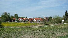
Hummel (Langenbach)
|
Hummel
(upper and lower bumblebee ) Community Langenbach
Coordinates: 48 ° 25 ′ 37 ″ N , 11 ° 52 ′ 22 ″ E
|
|
|---|---|
| Residents : | 1023 (June 30, 2014) |
| Incorporation : | May 1, 1978 |
| Postal code : | 85416 |
| Area code : | 08761 |
Hummel is the name of a former Hofmark and the common name for the districts of Ober- and Niederhummel of Langenbach in Upper Bavaria. The municipality of Oberhummel with the suburbs Niederhummel and Windham existed from 1818 to 1978.
geography
Hummel is located near the Isar, southeast of Langenbach and is divided into the parish village of Oberhummel (495 inhabitants) and the parish village of Niederhummel (505 inhabitants). The hamlet of Windham, which is also part of the Oberhummel district, has 23 residents.
In the Isarauen nature reserve between Hangenham and Moosburg , the Moosach flows into the Isar directly under the Isar bridge on the road to Gaden . The Mühlbach , diverted shortly before the mouth, crosses Oberhummel and flows past Niederhummel towards Moosburg .
history
The first mention of Hummel can be found in a Freising document dated May 31, 808 as "Humpla". The land register of the Hochstift Freising, which was created around 1180, distinguishes for the first time between Oberhummel ("Humblin superius") and Niederhummel ("Humblin inferius"). Hummel was a closed Hofmark from 1284 , which included the places Oberhummel, Niederhummel and Windham and was in the Bavarian district court of Kranzberg. Hofmarksherr was the Hochstift Freising , which was then dissolved in 1803 as part of the secularization in Bavaria . The Hofmark Hummel came into the possession of the Electorate and later Kingdom of Bavaria. With the community edict of 1818, the community Oberhummel was formed with Niederhummel and Windham. This municipality was dissolved on May 1, 1978 on the occasion of the municipal reform and incorporated into the municipality of Langenbach.
Attractions
- Church of St. Andreas in Niederhummel from the 14th century
- Parish church of St. Georg and St. Dionysius in Oberhummel
Individual evidence
- ^ Federal Statistical Office (ed.): Historical municipality directory for the Federal Republic of Germany. Name, border and key number changes in municipalities, counties and administrative districts from May 27, 1970 to December 31, 1982 . W. Kohlhammer GmbH, Stuttgart and Mainz 1983, ISBN 3-17-003263-1 , p. 575 .
- ↑ Georg Brenninger: The parish church in Oberhummel . In: Amperland , 1980, pp. 11-14.

