
Attenkirchen
| coat of arms | Germany map | |
|---|---|---|

|
Coordinates: 48 ° 30 ' N , 11 ° 46' E |
|
| Basic data | ||
| State : | Bavaria | |
| Administrative region : | Upper Bavaria | |
| County : | Freising | |
| Management Community : | Zolling | |
| Height : | 524 m above sea level NHN | |
| Area : | 16.11 km 2 | |
| Residents: | 2817 (Dec. 31, 2019) | |
| Population density : | 175 inhabitants per km 2 | |
| Postal code : | 85395 | |
| Area code : | 08168 | |
| License plate : | FS | |
| Community key : | 09 1 78 115 | |
| LOCODE : | DE AKC | |
| Community structure: | 23 parts of the community | |
| Address of the municipal administration: |
Hauptstrasse 5 85395 Attenkirchen |
|
| Website : | ||
| First Mayor : | Mathias Kern (WE) | |
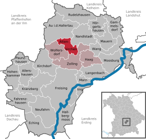
| Location of the community Attenkirchen in the district of Freising | ||
  |
||


Attenkirchen is a municipality and a village in the Upper Bavarian district of Freising and a member of the Zolling administrative community . The place is considered the southern gateway to Hallertau , Germany's largest hop growing area .
geography
location
The community is located in the tertiary hill country about 13 kilometers north of the district town of Freising and a few kilometers north of the Ampertal . Attenkirchen is on the B 301 (Hallertauer Hopfenstrasse). In the community, the high wood and wire frames of the hop gardens begin to shape the landscape.
Districts
There are 23 officially named municipal parts (the type of settlement is given in brackets ):
|
|
|
history
Until the church is planted
The place was first mentioned in a Freising document from July 30, 830. At that time the priest Uualdperth (Waldpercht) donated his property to the church Zartinchircha and the Freising Cathedral. In the place there was an open Hofmark with subjects in Attenkirchen, Gfeichet, Einhausen and Reit. From 1447 it was owned by the Ranolzhauser, from 1465 by Westendorfer, then from 1483 by Pullinger and Lung von Tandern. In 1560 Jakob von Thurn zu Au acquired the entire Hofmark, which in 1616 went to the Lords of Flitzing . From 1632 until the 19th century the Hofmark was owned by the Counts of Lodron . Politically, Attenkirchen was part of the Landshut Rent Office and the Moosburg Regional Court . In the course of the administrative reforms in Bavaria in 1818, the place became an independent political municipality.
Incorporations
As part of the municipal reform , the municipalities of Pfettrach, Sillertshausen and parts of the municipality of Wimpasing were incorporated on April 1, 1971. On July 1, 1972, parts of the former municipality of Reichertshausen were added.
Outsourcing
After the district reform, the residents of Sillertshausen and Held demanded that they move to Au. On January 1, 1982, the small area with then around 40 inhabitants was assigned to the Au market in the Hallertau.
Population development
Between 1988 and 2018 the municipality grew from 1,517 to 2,761 by 1,244 inhabitants or by 82%.
politics
Municipal council
Four parliamentary groups are represented in the Attenkirchen municipal council. Since the municipal council election on March 15, 2020, the cross-party voter association WIR 5, founded in September 2019, the community- oriented group (BG) 4 organized by the Free Voters , the UWG (Independent Voters' Association), which was outstanding in 2014 from parts of the CSU parliamentary group, 3 and the Green open list 2 municipal councils.
Mathias Kern (WIR) already prevailed in the first ballot of the mayoral election on March 15, 2020 with 50.2% against incumbent Martin Bormann (2014–2020) from the community-based group and Walter Schlott from the Green Open List.
On May 4, 2020 Hermann Lachner (community group) was re-elected as 2nd mayor and Sepp Fischer (UWG) as 3rd mayor of the community of Attenkirchen for the first time. Both received 10 votes from local councils.
coat of arms
The municipal coat of arms, approved in 1985, shows "a red-armored, silver lion in blue holding a golden hop umbel in its paws".

Attractions
- Parish Church of St. Johannes Baptist in Attenkirchen
- Filial church St. Peter in Hettenkirchen
- St. Lantbert Church in Pfettrach
traffic
The B 301 leads through the village from Abensberg to Freising . Until the shutdown of the small railway, Attenkirchen was connected to the rail network via the Hallertau local railway from Langenbach to Enzelhausen . Today the next train stations are in Freising and Pfaffenhofen an der Ilm . The former route of the Hallertau local railway has been used for some time to create a railway cycle path that is intended to open up the Hallertau for this type of traffic, among other things. a. to promote tourism. There is a public transport connection with the MVV bus line 602 (Freising-Mainburg).
Events
The community of Attenkirchen organizes the Hallertau Beer Festival every two years .
literature
- Georg Schranner: A lawsuit because of the licensing rights in Pfettrach and Hettenkirchen . In: Amperland , Volume 1, 1965, pp. 67–71.
Web links
- Homepage
- Entry on the coat of arms of Attenkirchen in the database of the House of Bavarian History
Individual evidence
- ↑ "Data 2" sheet, Statistical Report A1200C 202041 Population of the municipalities, districts and administrative districts 1st quarter 2020 (population based on the 2011 census) ( help ).
- ^ Community Attenkirchen: Attenkirchen and surroundings. Retrieved May 24, 2020 .
- ^ Attenkirchen community in the local database of the Bavarian State Library Online . Bayerische Staatsbibliothek, accessed on September 12, 2019.
- ^ Wilhelm Volkert (ed.): Handbook of Bavarian offices, communities and courts 1799–1980 . CH Beck, Munich 1983, ISBN 3-406-09669-7 , p. 464 .
- ^ Federal Statistical Office (ed.): Historical municipality directory for the Federal Republic of Germany. Name, border and key number changes in municipalities, counties and administrative districts from May 27, 1970 to December 31, 1982 . W. Kohlhammer, Stuttgart / Mainz 1983, ISBN 3-17-003263-1 , p. 814 .

Allershausen | Attenkirchen | Au in the Hallertau | Eching | Fahrenzhausen | Freising | Gammelsdorf | Hague an der Amper | Hallbergmoos | Hohenkammer | Hörgertshausen | Kirchdorf an der Amper | Kranzberg | Langenbach | Marzling | Walls | Moosburg on the Isar | Nandlstadt | Neufahrn near Freising | Paunzhausen | Rudelzhausen | Wang | Wolfersdorf | Zolling