
Hohenkammer
| coat of arms | Germany map | |
|---|---|---|

|
Coordinates: 48 ° 25 ' N , 11 ° 31' E |
|
| Basic data | ||
| State : | Bavaria | |
| Administrative region : | Upper Bavaria | |
| County : | Freising | |
| Height : | 471 m above sea level NHN | |
| Area : | 25.74 km 2 | |
| Residents: | 2634 (Dec. 31, 2019) | |
| Population density : | 102 inhabitants per km 2 | |
| Postal code : | 85411 | |
| Primaries : | 08137, 08166 | |
| License plate : | FS | |
| Community key : | 09 1 78 133 | |
| LOCODE : | DE ZOH | |
| Community structure: | 16 parts of the community | |
| Address of the municipal administration: |
Petershauser Strasse 1 85411 Hohenkammer |
|
| Website : | ||
| Mayor : | Johann Stegmair ( CSU ) | |
| Location of the municipality of Hohenkammer in the Freising district | ||
  |
||


Hohenkammer is a municipality in the Upper Bavarian district of Freising .
geography
Hohenkammer lies on the Glonn at the intersection of the federal highway 13 (Würzburg - Ingolstadt - Munich - Sylvensteinsee) with the state road 2054 (Landsberg am Lech - Markt Indersdorf - Allershausen - Kirchdorf - Geisenhausen).
Community structure
The municipality has 16 officially named municipality parts (the type of settlement is indicated in brackets ):
|
|
|
history

The place was first mentioned in 734 as "Chamara". The current place name was not used until the 16th century. The original castle belonged to the Lords of Kammer and Camer, first attested in the 11th century. They were ministerials to the Counts of Scheyern . From 1551 to 1801 the closed Hofmark Hohenkammer was owned by the Counts of Haslang , who built Hohenkammer Castle on the site of the castle . With the second municipal edict in Bavaria , Hohenkammer became an independent political municipality in 1818. Before 1855 the place Oberwohlbach was incorporated, on January 1, 1972 territorial parts of the municipality Schlipps followed . On April 1, 1972, parts of the dissolved community of Lauterbach were added.
Population development
Between 1988 and 2018 the municipality grew from 1,670 to 2,662 by 992 inhabitants or by 59.4%.
Attractions
See also: List of architectural monuments in Hohenkammer
- Hohenkammer Castle
- Parish Church of St. John Evangelist
- Former rectory with hipped roof, built in 1702
politics
Municipal council
The local elections in 2002, 2008 and 2014 led to the following allocation of seats in the local council . With the 2014 local elections, the CSU's list connection with the citizens 'association broke up, which lasted two terms and the Hohenkammer citizens' association moved into the municipal council with its own list. The SPD joined in 2002 as the “SPD / Citizens List”; from 2008 again as SPD. Since March 2014, a total of five parties or electoral associations are represented in the new municipal council; Never that many before.
| Party / group of voters | 2002 | 2008 | 2014 |
|---|---|---|---|
| CSU | 11 | 10 | 5 |
| SPD | 3 | 3 | 2 |
| FDP | - | 1 | 1 |
| Green | - | - | 1 |
| Hohenkammer citizens' association | - | - | 5 |
| total | 14th | 14th | 14th |
The percentage was voted as follows:
| Party / group of voters | 2002 | 2008 | 2014 |
|---|---|---|---|
| CSU | 76.2 | 65.3 | 35.3 |
| Hohenkammer citizens' association | - | - | 37.1 |
| SPD | 23.8 | 24.0 | 12.0 |
| FDP | - | 10.3 | 9.2 |
| Green | - | - | 6.4 |
| total | 100 | 100 | 100 |
mayor
The incumbent First Mayor Johann Stegmair of the CSU was confirmed for a fourth term in March 2014 with 68.2% of the votes. He has been in office since May 1996.
Former mayors:
- 1912–1936: Franz Petz
- 1936–1946: Anton Geisenhofer
- 1946–1966: Michael Rottenkolber
- 1966–1972: Josef Lechner
- 1972–1978: Josef Kistler
- 1978–1996: Georg Ziegltrum
Economy and Infrastructure
After changing owners, the castle is now owned by Munich Re , which operates a training center through the newly founded Hohenkammer Castle Academy.
The B 13 runs through Hohenkammer between Munich and Ingolstadt . The A 9 and Petershausen train station are each five kilometers away. In Petershausen there is a connection to the Munich S-Bahn and regional trains to Munich, Ingolstadt and Nuremberg ( Munich-Nuremberg Express ). There is a public transport connection with the MVV bus routes 616, 619 and 785.
The Altbaierischer Oxenweg , originally used as a trade route, now connects the place as a touristic signposted cycle and hiking route with neighboring Petershausen and continues to Augsburg.
In the community there is a municipal ( child's house ) and a Catholic kindergarten as well as a primary school. There is also a community library.
The Hohenkammer sports club has existed since 1947 and can use two soccer fields and a sports hall.
Personalities
- Ernst von Gagern (1807–1865), worked as a cooperator in Hohenkammer in the 1830s
- Theodor Mathieu (1919–1995), German politician (CSU) and Lord Mayor of Bamberg

Hohenkammer Castle (2019)

Hohenkammer Castle (left) with Hohenkammer conference hotel (right)
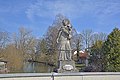
St. Nepomuk as bridge saint on the Glonnbrücke in Hohenkammer

Hohenkammer (view from north-northwest) - right with Hohenkammer Castle
.jpg)


.JPG)
literature
- Georg Dehio : Handbook of the German art monuments . Volume IV: Munich and Upper Bavaria. Deutscher Kunstverlag, Munich, Berlin 1990, ISBN 3-422-03010-7 , pp. 449–451.
Web links
- Hohenkammer community
- Hohenkammer Castle
- Entry on the Hohenkammer coat of arms in the database of the House of Bavarian History
Individual evidence
- ↑ "Data 2" sheet, Statistical Report A1200C 202041 Population of the municipalities, districts and administrative districts 1st quarter 2020 (population based on the 2011 census) ( help ).
- ^ Hohenkammer community in the local database of the Bavarian State Library Online . Bavarian State Library, accessed on September 11, 2019.
- ↑ Bavarian State Statistical Office (Hrsg.): Historical municipality register: The population of the municipalities of Bavaria in the period from 1840 to 1952 (= contributions to Statistics Bavaria . Issue 192). Munich 1954, DNB 451478568 , p. 8 , urn : nbn: de: bvb: 12-bsb00066439-3 ( digitized version ).
- ^ Wilhelm Volkert (ed.): Handbook of Bavarian offices, communities and courts 1799–1980 . CH Beck, Munich 1983, ISBN 3-406-09669-7 , p. 464 .
- ↑ http://www.wahlen.bayern.de/kommunalwahlen/index.php
- ↑ http://www.hohenkammer.de/Namensverzeichnis-der-Buergermeister.o2545.html

Allershausen | Attenkirchen | Au in the Hallertau | Eching | Fahrenzhausen | Freising | Gammelsdorf | Hague an der Amper | Hallbergmoos | Hohenkammer | Hörgertshausen | Kirchdorf an der Amper | Kranzberg | Langenbach | Marzling | Walls | Moosburg on the Isar | Nandlstadt | Neufahrn near Freising | Paunzhausen | Rudelzhausen | Wang | Wolfersdorf | Zolling