
Neufahrn near Freising
| coat of arms | Germany map | |
|---|---|---|

|
Coordinates: 48 ° 19 ′ N , 11 ° 40 ′ E |
|
| Basic data | ||
| State : | Bavaria | |
| Administrative region : | Upper Bavaria | |
| County : | Freising | |
| Height : | 464 m above sea level NHN | |
| Area : | 45.53 km 2 | |
| Residents: | 20,165 (Dec. 31, 2019) | |
| Population density : | 443 inhabitants per km 2 | |
| Postcodes : | 85375, 85376 | |
| Area code : | 08165 | |
| License plate : | FS | |
| Community key : | 09 1 78 145 | |
| LOCODE : | DE NFF | |
| Community structure: | 8 parts of the community | |
| Address of the municipal administration: |
Bahnhofstrasse 32 85375 Neufahrn |
|
| Website : | ||
| Mayor : | Franz Heilmeier ( Alliance 90 / The Greens ) | |
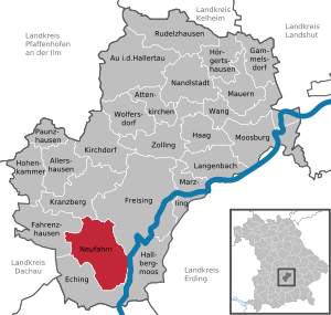
| Location of the municipality of Neufahrn near Freising in the Freising district | ||
  |
||

Neufahrn bei Freising (officially: Neufahrn b.Freising ) is a municipality in the Upper Bavarian district of Freising . In the local Bavarian dialect , the place is called Neifahrn . Neufahrn is to the left of the Isar on the border between the Munich gravel plain and the tertiary Danube-Isar hill country , approx. 10 km south of Freising and almost 20 km northeast of the Bavarian capital Munich .
geography
Geographical location
The main town of Neufahrn is located in the north of the Munich gravel plain in a historical heathland and marks the highest point of a gravel tongue that extends to the Massenhausener Moos. The Freisinger Moos connects to the north . The landscape around Neufahrn and Mintraching / Grüneck is almost completely flat and only slopes slightly to the north. The northern districts border on the tertiary hill country, Hetzenhausen lies on a ridge between the Isar and Ampertal valleys and is 499 m above sea level. NN the highest district. The Isar flows east of the municipality, less than 3 km from the center of Neufahrn and only a few hundred meters from Mintraching . The district is surrounded by some nature and landscape protection areas, including the Garchinger Heide , the Echinger Lohe and the Echinger Gfild.
Around 15% of the municipality's land area is settlement and traffic area. The remaining part consists almost entirely of agricultural land. There is no closed wooded area within the district.
The “Mühlseen”, three quarry ponds, were built north of Neufahrn in the early 1970s to cover the gravel required for the construction of the motorway to Deggendorf. The mill lakes initially lacked any infrastructure, and in 1983 the expansion measures for the recreation area began. The largest lake with around 9 hectares was designated as a sports lake, the 4.1 hectare lake was designed as a bathing lake and the smallest lake with 3.6 hectares was reserved for nature. The Galgenbachweiher (approx. 0.7 hectares of water) located on the northeastern outskirts of Neufahrn is the remainder of the former Galgenbach, which was filled in when the Munich-Landshut railway line was built in 1858. The farmers in the area mined gravel, later it was used as an experimental pond for carp breeding. In the 1970s, the Galgenbachweiher was recultivated and incorporated into the Neufahrner leisure and sports park.
Community structure
The municipality has eight officially named municipality parts (the type of settlement is indicated in brackets ):
|
|
Neighboring communities
The following cities and municipalities border the municipality of Neufahrn. In the north Fahrenzhausen and Kranzberg , in the northeast Freising , in the east Hallbergmoos and in the south and west Eching .
climate
The municipality of Neufahrn lies in the transition area between the humid Atlantic and the dry continental climate . The climate is humid all year round with an annual mean of around 8 degrees Celsius and 800 mm of precipitation. The weather is relatively changeable, the main precipitation falls, as usual in southern Germany, in summer. As a rule, the wind speeds are low, and there is often no wind. The foehn brings irregular warm, dry air currents from the south all year round. Associated with this is a very good view of the distance, so that the Northern Limestone Alps can be clearly seen.
history
Parish parts

Neufahrn
The most populous part of the municipality is the capital Neufahrn. The first documentary mention is found in 804 AD with the name "Niwiwara", which means something like "with the newly settled families". The center of Neufahrn is characterized by two main streets (Bahnhofstrasse and Echinger Strasse), along which a large part of the local infrastructure is concentrated. The second core is the industrial area directly adjacent to Eching .
.JPG)
Mintraching / Grüneck
The largest part of the community today is Mintraching / Grüneck, only about one kilometer east of the main town . The place in its present form emerged when the two previously separate places Mintraching and Grüneck grew together. Place signs with different names, depending on which direction you are coming from, are evidence of this. The first documented mentions date from the years 762 and 764 AD. At that time it was called "Munrihhinga" or "Munirinchingun". The townscape is shaped by the church of St. Margaret. It is a late Gothic building, which was baroque in the 18th century and received an onion dome. The village was dominated by agriculture until the post-war period, today a new industrial area with a logistics park is being built.

Giggenhausen
A first settler named Gueticho probably gave Giggenhausen (Guetichenhusen) his name. Giggenhausen was the parish seat from the earliest times. It was not until 1390 that the church became a branch church of the Massenhausen parish. Like all the surrounding towns, the village suffered badly from the devastating consequences of the Thirty Years' War. The diplomat and Canon Puech, who was at the same time pastor in Massenhausen, succeeded in averting even worse calamities in the last years of the war. He obtained letters of protection, on the one hand from the Swedish general Wrangel, on the other hand from the French commander Turenne, for the towns around Freising. The Austrian War of Succession drove Giggenhausen back to ruin around a hundred years later. In 1745 around 22,000 men camped in the villages from Daitenhausen to Hohenbachern and in Gfild. The farmers hardly had a piece of bread left to eat. Finally, Napoleon's troops passed through to the villagers in the period around 1805. Nevertheless, the battered village managed to set up its own school in 1837. The community of Giggenhausen, to which in addition to Giggenhausen also Schaidenhausen and the Moosmühle belonged, came to Massenhausen on January 1, 1972. With this it came to Neufahrn on May 1st, 1978.
Massenhausen
The history of Massenhausen is initially determined by the Massenhausen noble family. Their manorial rule extended to Schloss Massenhausen, Schloss Täsingen (Dasing), groups of courtyards or individual properties in the surrounding villages. 887 to 895 there are first mentions of the residence "Massinhuson" in old documents. In 1499 Massenhausen came to the cathedral monastery of Freising and to the municipality of Neufahrn in 1820. In the second half of the 19th century, the regulation of Moosach and Mauka succeeded in gaining good arable and pasture land. The rich church treasure of the Gothic parish church To Our Lady testifies to the former splendor of the Massenhausen castle lords. The furnishings of the church are also otherwise remarkable.
On January 1, 1972, Massenhausen incorporated the previously independent Giggenhausen and came to Neufahrn on May 1, 1978.

Fürholzen
Fürholzen is located a few kilometers northwest of Neufahrn on the edge of the Tertiary hill country. The first written mention of Furiholci (“in front of the wood”, in front of the forest) dates from the year 772. The foundation of the parish and the construction of the first church also fall at this time. The parish was given as a benefice to the Freising cathedral clergy and initially looked after by assistant priests and vicars. It was also the clergy who shaped Fürholz's development for centuries. In 1723 a new parish church was built in baroque style. The first school opened in 1852.
Robert Lembke hid in Fürholzen from September 1944 until the end of the war in 1945. Fürholzen belonged to the community of Massenhausen, which was attached to Neufahrn on May 1, 1978.
Hetzenhausen
Celtic finds prove that at the site of Hetzenhausen as early as 450 BC Chr. People settled. It is difficult for the local history researchers to filter out the first documented mention of the village from the existing, early records. The names Zezinhusir, Zezinhusa, Hezinhusa or Zezinhusen are common. But it is not clear whether Hetzenhausen or Etzenhausen in the Dachau district is meant. It cannot be clearly proven, but there is much to suggest that Hetzenhausen had an important son in the high Middle Ages. Neidhart von Reuental was one of the most famous poets and minstrels of his time. The structural core of today's Hetzenhausen village church St. Martin probably dates from the second half of the 13th century. A renovation was made in 1709. The sculptural jewelry of St. Martins is worth seeing. It is attributed to masters of the Munich School towards the end of the 15th century. Hetzenhausen belonged to the community of Massenhausen, which was attached to Neufahrn on May 1, 1978.
Population development
Between 1988 and 2018 the municipality grew from 14,610 to 20,223 by 5,613 inhabitants or by 38.4%.

| date | Residents |
|---|---|
| December 1, 1840 | 1,114 |
| December 1, 1871 | 1,479 |
| December 1, 1900 | 1,676 |
| June 16, 1925 | 2.167 |
| May 17, 1939 | 2,108 |
| September 13, 1950 | 3,247 |
| June 6, 1961 | 4,007 |
| May 27, 1970 | 8,735 |
| May 25, 1987 | 14,120 |
| December 31, 1991 | 15,255 |
| December 31, 1995 | 15,836 |
| December 31, 2004 | 18,415 |
| December 31, 2010 | 19,046 |
| May 9, 2011 | 18,392 |
| December 31, 2015 | 19,468 |
| December 31, 2018 | 20,223 |
Source: Bavarian State Office for Statistics and Data Processing / Neufahrn municipality
politics
Municipal council
The local elections in 2002, 2008 , 2014 and 2020 produced the following results:
| Party / group of voters | 2002 | 2008 | 2014 | 2020 |
|---|---|---|---|---|
| Green | 1 | 2 | 4th | 8th |
| CSU | 7th | 6th | 6th | 7th |
| SPD | 4th | 4th | 3 | 3 |
| ÖDP | 1 | 1 | 1 | 2 |
| AfD | - | - | - | 1 |
| FDP | 1 | 2 | 2 | 1 |
| Free voters | 10 | 9 | 5 | 6th |
| Citizens for Neufahrn | - | - | 3 | 2 |
| total | 24 | 24 | 24 | 30th |
| Party / group of voters | 2002 | 2008 | 2014 | 2020 |
|---|---|---|---|---|
| Green | 5.7% | 10.5% | 18.7% | 27.6% |
| CSU | 29.7% | 24.8% | 24.8% | 23.2% |
| SPD | 15.8% | 14.0% | 14.0% | 9.8% |
| ÖDP | 4.6% | 5.6% | 5.3% | 6.1% |
| AfD | - | - | - | 4.6% |
| FDP | 5.9% | 7.1% | 6.3% | 2.9% |
| left | - | - | - | 1.0% |
| Free voters | 38.3% | 38.0% | 18.8% | 18.2% |
| Citizens for Neufahrn | - | - | 11.9% | 6.7% |
| total | 100% | 100% | 100% | 100% |
mayor
In 2014, Franz Heilmeier was elected first mayor by the Greens in the runoff election with 59.07%. He is the first mayor of the Greens in the Freising district. In the 2020 local elections, he was confirmed as one of six applicants with 50.65% of the valid votes.
coat of arms
Blazon : "In green, a flat half, golden point , inside a golden pierced black 10-fold gear with a golden ring, a growing golden recross with elongated side arms."
Declaration of coat of arms: The coat of arms of the municipality of Neufahrn consists of two parts, the upper part symbolizing the old and the lower part the modern Neufahrn. The upper part consists of a yellow cross on a green background and represents the old community of Neufahrn. The cross is the Wilgefortis cross, which is also located on the main altar of St. Wilgefortis in Neufahrn. The green in the coat of arms refers to the heathland - the so-called "Gfild" on which Neufahrn lies. The lower part of the shield with a black cog wheel with a golden tip symbolically represents the settlement of handicrafts and trades on golden soil.

Community partnerships
In 1983 Neufahrn entered into a partnership with Gardolo , a district in the north of the northern Italian city of Trento .
North Alliance
Neufahrn is a member of the North Alliance - Munich North Metropolitan Region .
Architectural monuments
The old parish and pilgrimage church of St. Wilgefortis dates from the 14th / 15th centuries. Century and was consecrated in 1499. It was baroque in 1715 .
Economy and Infrastructure
traffic
.jpg)

West of the town at the Neufahrn junction , the federal highways 9 (Munich - Nuremberg) and 92 (Munich - Deggendorf) intersect . The closest exits are “Eching / Neufahrn” (A 9), “Eching Ost” (A 92) and “Freising Süd” (A92), which connects the Mintraching / Grüneck district. State road 2350 (former federal road 11 ) leads through the district of Mintraching .
The Neufahrner Bahnhof is on the Munich – Regensburg railway line .
![]() : Neufahrn is connected by the S-Bahn line S1 of the Munich Transport and Tariff Association (MVV) with the state capital of Munich, the district town of Freising and Munich Airport . The S1 takes a good 30 minutes from Munich main train station to Neufahrn train station. a. Direct connection to the Munich subway network in the Feldmoching and Moosach stations . The S1 runs between Munich and the airport every 20 minutes during the day. In Neufahrn, the northern section of the S1 splits into two branches with the terminus Freising and Munich Airport.
: Neufahrn is connected by the S-Bahn line S1 of the Munich Transport and Tariff Association (MVV) with the state capital of Munich, the district town of Freising and Munich Airport . The S1 takes a good 30 minutes from Munich main train station to Neufahrn train station. a. Direct connection to the Munich subway network in the Feldmoching and Moosach stations . The S1 runs between Munich and the airport every 20 minutes during the day. In Neufahrn, the northern section of the S1 splits into two branches with the terminus Freising and Munich Airport.
![]()
![]() : With the bus lines 690 and 692 that run here, Neufahrn also has a connection to the Hallbergmoos S8 station and the Munich underground line U6 , whereby the journey time from the Mintraching / Grüneck district to the Hallbergmoos S-Bahn station is just 3 minutes. Since the S1, S8 and U6 approach the center of Munich from different directions, large parts of Munich can be reached in a short time. After a positive feasibility study from 2008, an extension of the U6 to the Neufahrn S-Bahn station is currently being investigated again in order to improve the airport connection to the north of Munich and connect the university locations as well as adapting the infrastructure to the expected population growth to reach.
: With the bus lines 690 and 692 that run here, Neufahrn also has a connection to the Hallbergmoos S8 station and the Munich underground line U6 , whereby the journey time from the Mintraching / Grüneck district to the Hallbergmoos S-Bahn station is just 3 minutes. Since the S1, S8 and U6 approach the center of Munich from different directions, large parts of Munich can be reached in a short time. After a positive feasibility study from 2008, an extension of the U6 to the Neufahrn S-Bahn station is currently being investigated again in order to improve the airport connection to the north of Munich and connect the university locations as well as adapting the infrastructure to the expected population growth to reach.
Munich International Airport is located about 10 km east in the Erdinger Moos.
Established businesses
MAN , Schenker AG , BMW and other companies with individual locations are located in the industrial park adjacent to Eching . DPD has a branch in Neufahrn.
education
- seven kindergartens
- a hoard
- two lunchtime care
- four schools: two primary schools, a middle school and the Oskar-Maria-Graf-Gymnasium
sport and freetime
The former Bundesliga tennis club TC Blau-Weiß Neufahrn is based in Neufahrn .
TSV Neufahrn, FC Neufahrn and the Neufun indoor swimming pool are located in the leisure and sports park east of the town and the railway line .
Personalities
- Gleb Rahr (1922–2006), Russian exile journalist and church historian, lived in Neufahrn from 1975–1980.
- Hans-Heinrich Held (1957–2015), eventing rider and farmer
- Christian Grundner (* 1968), ultra-long distance runner, lives in Neufahrn
Web links
- Website of the municipality of Neufahrn bei Freising
- Chronicle of the districts of Neufahrn near Freising
- Site of the village of Giggenhausen
- Entry on the coat of arms of Neufahrn near Freising in the database of the House of Bavarian History
Individual evidence
- ↑ "Data 2" sheet, Statistical Report A1200C 202041 Population of the municipalities, districts and administrative districts 1st quarter 2020 (population based on the 2011 census) ( help ).
- ^ Community Neufahrn in the local database of the Bayerische Landesbibliothek Online . Bavarian State Library, accessed on September 11, 2019.
- ↑ a b Wilhelm Volkert (Ed.): Handbook of the Bavarian offices, communities and courts 1799–1980 . CH Beck, Munich 1983, ISBN 3-406-09669-7 , p. 464 .
- ↑ a b c d Federal Statistical Office (Hrsg.): Historical municipality register for the Federal Republic of Germany. Name, border and key number changes in municipalities, counties and administrative districts from May 27, 1970 to December 31, 1982 . W. Kohlhammer, Stuttgart / Mainz 1983, ISBN 3-17-003263-1 , p. 575 .
- ↑ Alexandra Vettori: Moderator Robert Lembke: Hidden in Fürholzen. Retrieved July 20, 2020 .
- ↑ https://neufahrn.de/fileadmin/wahlen/Wahl-2020-03-15/09178145/html5/Gemeinderatswahl_Bayern_16_Gemeinde_Gemeinde_Neufahrn_bFreising.html Municipal council election 2020, municipality Neufahrn b. Freising, overall result
- ↑ https://www.merkur.de/lokales/muenchen-lk/mit-tram-durch-norden-7431078.html
- ↑ The Russian Munich. Publishing house Mir e. V., Munich 2010. ISBN 978-3-9805300-9-5

Allershausen | Attenkirchen | Au in the Hallertau | Eching | Fahrenzhausen | Freising | Gammelsdorf | Hague an der Amper | Hallbergmoos | Hohenkammer | Hörgertshausen | Kirchdorf an der Amper | Kranzberg | Langenbach | Marzling | Walls | Moosburg on the Isar | Nandlstadt | Neufahrn near Freising | Paunzhausen | Rudelzhausen | Wang | Wolfersdorf | Zolling