
Enzelhausen
|
Enzelhausen
community Rudelzhausen
Coordinates: 48 ° 34 ′ 52 ″ N , 11 ° 45 ′ 7 ″ E
|
||
|---|---|---|
| Height : | 442 m above sea level NHN | |
| Residents : | 1356 | |
| Incorporation : | May 1, 1978 | |
| Postal code : | 84104 | |
| Area code : | 08752 | |
Location of Enzelhausen in Bavaria |
||
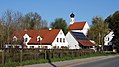
 View of Enzelhausen
|
||

Enzelhausen is a district of the municipality of Rudelzhausen in Upper Bavaria . The village is located in the Hallertau , the most important hop growing region in Germany, and has 1,356 inhabitants.
history
The place belonged to the Landshut Rent Office and the Moosburg Regional Court of the Electorate of Bavaria . Up to the early 19th century, existing chairman shaft Enzelhausen the Office Nandlstadt in district court Moosburg included the places Enzelhausen, Lars Bach and Iglsdorf.
In the course of the administrative reforms in Bavaria, the municipality of Enzelhausen was created with the municipal edict of 1818 , to which the district of Rudelzhausen also belonged. On July 1, 1972, the previously independent municipalities of Grünberg and parts of the municipality of Berg were incorporated into the municipality of Enzelhausen. Enzelhausen, Tegernbach and parts of the dissolved Grafendorf community were finally combined on May 1, 1978 to form the new community of Rudelzhausen.
Economy and Infrastructure
The typical rural character is particularly evident in the numerous surrounding hop gardens in the tertiary hill country .
Until they were closed, Enzelhausen had a train station on the Hallertau local railway . This is where the Wolnzach – Mainburg and Langenbach – Enzelhausen routes met . The station area with the remaining tracks is privately owned and is used as a junkyard. There are also several old rail vehicles on the site.
Enzelhausen with Schimmelkapelle

Enzelhausen Schimmelkapelle

Schimmelkapelle: interior

Schimmelkapelle: main altar
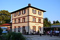
Former Enzelhausen station


Individual evidence
- ↑ Müller's Large German Local Book 2012: Complete local dictionary. Walter De Gruyter, Munich 2012, ISBN 978-3-11-027420-2 , p. 337.
- ^ Wilhelm Volkert (ed.): Handbook of Bavarian offices, communities and courts 1799–1980 . CH Beck, Munich 1983, ISBN 3-406-09669-7 , p. 516 .
- ^ Federal Statistical Office (ed.): Historical municipality directory for the Federal Republic of Germany. Name, border and key number changes in municipalities, counties and administrative districts from May 27, 1970 to December 31, 1982 . W. Kohlhammer GmbH, Stuttgart / Mainz 1983, ISBN 3-17-003263-1 , p. 575 .