
Administrative community Zolling
| coat of arms | Germany map | |
|---|---|---|
 Help on coat of arms |
Coordinates: 48 ° 27 ' N , 11 ° 46' E |
|
| Basic data | ||
| State : | Bavaria | |
| Administrative region : | Upper Bavaria | |
| County : | Freising | |
| Area : | 98.41 km 2 | |
| Residents: | 13,243 (Dec. 31, 2019) | |
| Population density : | 135 inhabitants per km 2 | |
| License plate : | FS | |
| Association key : | 09 1 78 5130 | |
| Association structure: | 4 municipalities | |
| Association administration address : |
Rathausplatz 1 85406 Zolling |
|
| Website : | ||
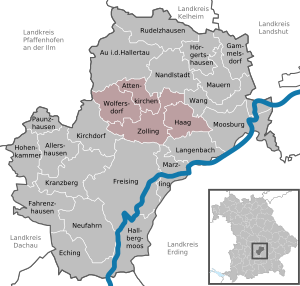
| Location of the Zolling administrative community in the Freising district | ||
  |
||

The Zolling administrative community is located in the Upper Bavarian district of Freising and is formed by the following communities:
- Attenkirchen , 2817 inhabitants, 16.11 km²
- Haag adAmper , 2965 inhabitants, 21.71 km²
- Wolfersdorf , 2602 inhabitants, 26.05 km²
- Zolling , 4859 inhabitants, 34.54 km²
The administrative association is based in Zolling.
Community meeting
The community assembly consists of 18 people, chaired by the 1st mayor of Zolling, Maximilian Riegler.
Individual evidence
- ↑ "Data 2" sheet, Statistical Report A1200C 202041 Population of the municipalities, districts and administrative districts 1st quarter 2020 (population based on the 2011 census) ( help ).
- ^ VG Zolling
Administrative communities in the Freising district
Allershausen | Walls | Zolling
Disbanded: Langenbach