
Administrative community Allershausen
| coat of arms | Germany map | |
|---|---|---|
 Help on coat of arms |
Coordinates: 48 ° 26 ' N , 11 ° 36' E |
|
| Basic data | ||
| Existing period: | 1978– | |
| State : | Bavaria | |
| Administrative region : | Upper Bavaria | |
| County : | Freising | |
| Area : | 39.28 km 2 | |
| Residents: | 7355 (Dec. 31, 2019) | |
| Population density : | 187 inhabitants per km 2 | |
| License plate : | FS | |
| Association key : | 09 1 78 5127 | |
| Association structure: | 2 municipalities | |
| Association administration address : |
Johannes-Boos-Platz 6 85391 Allershausen |
|
| Website : | ||
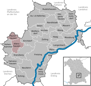
| Location of the administrative community Allershausen in the Freising district | ||
  |
||

The administrative community Allershausen is located in the Upper Bavarian district of Freising and is formed by the following communities:
- Allershausen , 5840 inhabitants, 26.55 km²
- Paunzhausen , 1515 inhabitants, 12.73 km²
The administrative community is based in Allershausen . The administrative community, founded in 1978 , initially also included the communities of Kirchdorf adAmper and Hohenkammer .
Individual evidence
- ↑ "Data 2" sheet, Statistical Report A1200C 202041 Population of the municipalities, districts and administrative districts 1st quarter 2020 (population based on the 2011 census) ( help ).
- ↑ Kirchdorf was released on January 1, 1994, Law and Ordinance Gazette 1993, p. 830
- ↑ Dismissed by the Fifth Act to Change the Structure of Municipalities and Administrative Communities of July 26, 1997 (GVBl p. 309) on January 1, 1998
Administrative communities in the Freising district
Allershausen | Walls | Zolling
Disbanded: Langenbach