
Kirchdorf an der Amper
| coat of arms | Germany map | |
|---|---|---|

|
Coordinates: 48 ° 28 ' N , 11 ° 39' E |
|
| Basic data | ||
| State : | Bavaria | |
| Administrative region : | Upper Bavaria | |
| County : | Freising | |
| Height : | 440 m above sea level NHN | |
| Area : | 32.96 km 2 | |
| Residents: | 3256 (Dec. 31, 2019) | |
| Population density : | 99 inhabitants per km 2 | |
| Postal code : | 85414 | |
| Area code : | 08166 | |
| License plate : | FS | |
| Community key : | 09 1 78 136 | |
| LOCODE : | DE KFR | |
| Community structure: | 16 parts of the community | |
| Address of the municipal administration: |
Rathausplatz 1 85414 Kirchdorf adAmper |
|
| Website : | ||
| Mayor : | Uwe Gerlsbeck | |
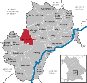
| Location of the municipality of Kirchdorf adAmper in the Freising district | ||
  |
||

Kirchdorf an der Amper (officially: Kirchdorf adAmper ) is a municipality in the Upper Bavarian district of Freising .
geography
location
The parish church is located in the village Ampertal , a large conservation area .
Parish parts
The municipality has 16 officially named municipality parts (the type of settlement is indicated in brackets ):
|
|
|
history
Until the church is planted
The parish of Nörting was first mentioned in the parish in 788 under the Freising Bishop Atto (783-811). The district of Helfenbrunn followed in 813.
In the year 1102 the local aristocratic family of the Kirchdorfer can be traced for the first time, which played an important role in the church village until it died out in 1423. Kirchdorf was a pastoral center founded by Weihenstephan in the lower Ampertal. The place was first mentioned in a document in 1123. The parish was incorporated into the Neustift Premonstratensian monastery in Freising in 1358. The monastery also became the most important landlord in the municipality and had the Kirchdorf church rebuilt from 1706 to 1708. Kirchdorf was at times an important place of pilgrimage .
Until the end of the 18th century, Kirchdorf was part of the Länbach chairmanship of the Sichendorf office (near Zolling) in the Moosburg district court and became an independent political community in the course of the administrative reforms in Bavaria in 1818.
20th and 21st centuries
After the Second World War, the population of Kirchdorf increased sharply due to the inclusion of expellees . On March 12, 1979, the name of the municipality Kirchdorf was officially changed to Kirchdorf an der Amper (Kirchdorf adAmper) .
Religions
Catholic parishes in the municipality area Kirchdorf:
- Parish St. Martin in Kirchdorf with branch churches St. Katharina Nörting, St. Pankratius in Hirschbach and St. Georg in Palzing
- Parish of St. Nikolaus in Wippenhausen with branch churches in Burghausen and St. Clemens Oberberghausen
Incorporations
On January 1, 1972, areas of the dissolved communities Tünzhausen (the community part Schnotting) and Wippenhausen (Wippenhausen itself with Burghausen) were incorporated.
Population development
Between 1988 and 2018 the municipality grew from 1,863 to 3,235 by 1,372 inhabitants or by 73.6%.
politics
mayor
On March 16, 2014 Uwe Gerlsbeck (CSU) was elected as the new mayor.
The municipal council elected at the same time consists of the mayor and 8 members of the CSU / FW and 6 members of the FWG.
coat of arms
Blazon : Above a silver wave bar in red two upright, turned away golden stag poles, above an upright silver key with a forked beard.
Justification of the coat of arms: The silver wavy bar indicates the location of the municipality on the Amper. The two stag sticks do not point to the Hirschbach, which flows through the municipality, rather they should go back to the coat of arms of the local aristocratic family of the Kirchdorfer. The silver key indicates that it previously belonged to the Neustift monastery.
traffic
There is a public transport connection with the MVV bus lines 601 and 695.
Culture and sights
Attractions
- Parish church of St. Martin in Kirchdorf, in front of it a Marian column , which commemorates the fallen of the Franco-German War .
- Filial church St. Georg in Burghausen
- Chapel (Geierlambach)
- Chapel St. Sebald (Helfenbrunn)
- Filial church St. Pankratius in Hirschbach
- Filial church St. Katharina in Nörting
- Filial church St. Nikolaus and school in Wippenhausen
Sports
The local sports club is SC Kirchdorf e. V. , there are several shooting clubs: Schützenlust Wippenhausen , Schützenverein Edelweiß Hirschbach-Kirchdorf , Schützenverein Hubertus Helfenbrunn and Schützenverein Siegfried Nörting .
Others
In the context of community development, 18 working groups were founded in 2002. This resulted in the community development plan with the motto "Naturally well living in the Ampertal".
Web links
- http://www.gemeinde-kirchdorf-amper.de/
- Entry on the coat of arms of Kirchdorf an der Amper in the database of the House of Bavarian History
- Private website for the Hirschbach district
- Kirchdorf an der Amper: Official statistics of the LfStat
Individual evidence
- ↑ "Data 2" sheet, Statistical Report A1200C 202041 Population of the municipalities, districts and administrative districts 1st quarter 2020 (population based on the 2011 census) ( help ).
- ^ Community Kirchdorf an der Amper in the local database of the Bayerische Landesbibliothek Online . Bavarian State Library, accessed on September 11, 2019.
- ^ Federal Statistical Office (ed.): Historical municipality directory for the Federal Republic of Germany. Name, border and key number changes in municipalities, counties and administrative districts from May 27, 1970 to December 31, 1982 . W. Kohlhammer, Stuttgart / Mainz 1983, ISBN 3-17-003263-1 , p. 576 .
- ^ Wilhelm Volkert (ed.): Handbook of Bavarian offices, communities and courts 1799–1980 . CH Beck, Munich 1983, ISBN 3-406-09669-7 , p. 464 .
- ↑ http://www.wahlen.bayern.de/kommunalwahlen/

Allershausen | Attenkirchen | Au in the Hallertau | Eching | Fahrenzhausen | Freising | Gammelsdorf | Hague an der Amper | Hallbergmoos | Hohenkammer | Hörgertshausen | Kirchdorf an der Amper | Kranzberg | Langenbach | Marzling | Walls | Moosburg on the Isar | Nandlstadt | Neufahrn near Freising | Paunzhausen | Rudelzhausen | Wang | Wolfersdorf | Zolling