
Tuntenhausen
| coat of arms | Germany map | |
|---|---|---|

|
Coordinates: 47 ° 56 ' N , 12 ° 1' E |
|
| Basic data | ||
| State : | Bavaria | |
| Administrative region : | Upper Bavaria | |
| County : | Rosenheim | |
| Height : | 508 m above sea level NHN | |
| Area : | 69.01 km 2 | |
| Residents: | 7213 (Dec. 31, 2019) | |
| Population density : | 105 inhabitants per km 2 | |
| Postal code : | 83104 | |
| Primaries : | 08067, 08065 | |
| License plate : | RO , AIB , WS | |
| Community key : | 09 1 87 179 | |
| LOCODE : | DE TTH | |
| Community structure: | 57 districts | |
| Address of the municipal administration: |
Graf-Arco-Strasse 18 83104 Tuntenhausen |
|
| Website : | ||
| Mayor : | Georg Weigl ( CSU / FW ) | |
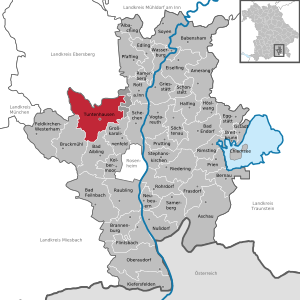
| Location of the community of Tuntenhausen in the district of Rosenheim | ||
  |
||

Tuntenhausen is a municipality in the Upper Bavarian district of Rosenheim .
geography
Community structure
The political municipality of Tuntenhausen has 57 officially named districts:
Neighboring communities
| Bavaria | Aßling , Emmering |
Rotter Forst-Nord (municipality-free area) |
.svg)
|
Rotter Forst-Süd (municipality-free area) |
|
| Bruckmühl | Bad Aibling | Großkarolinenfeld |
history


The place name refers to a settler named Tunti or Tunto, whose name has been handed down since around 770 and gave the place the name Tuntenhausen with changing spellings at the latest in the 13th century. The ending "-hausen" denotes a fortified residential complex or a castle.
The Marian pilgrimage in Tuntenhausen has existed since 1441, the year of the first recorded miracle. Since then, Tuntenhausen has been the destination of pilgrims from all parts of Old Bavaria and Tyrol . The parishes of Tuntenhausen and Schönau were incorporated into the Augustinian Canons of Beyharting in the middle of the 13th century . The monastery was an independent Hofmark and could also exercise certain rights. The higher-level legal organizations were the district courts of Rosenheim , Aibling and Schwaben ( Markt Schwaben ). Administrative units emerged after the secularization of 1803. The municipality of Tuntenhausen was expanded on May 1, 1978 as part of the municipal reform to include the municipalities of Beyharting and Hohenthann and the larger part of the municipality of Lampferding.
The place of pilgrimage is also known for the twice-yearly meeting of the Catholic Men's Association in Tuntenhausen , which is attended by leading Bavarian politicians from the CSU .
Population development
Between 1988 and 2018 the community grew from 4,603 to 7,150 by 2,547 inhabitants or 55.3%.
Municipal council
Local election March 16, 2014:
- CSU and Free Voting Community (CSU / FWG): 6 seats
- Women list (women list): 2 seats
- Free voter community Beyharting (FWG Beyharting): 2 seats
- Party-free community of voters in Schönau and the surrounding area (PF Schönau): 3 seats
- SPD, Alliance 90 / The Greens and Free Voters (SPD, B'90 / The Greens, FWS): 1 seat
- Independent voters Ostermünchen and surroundings (UW Ostermünchen): 3 seats
- Voting community Hohenthann and the surrounding area (WG Hohenthann): 3 seats
- Total: 20 seats
Attractions
- Pilgrimage church Tuntenhausen
- Catholic parish church of the Assumption in Lampferding
- Catholic parish church and former Augustinian canons' church of St. Johann Baptist in Beyharting
Transport links
- Munich – Rosenheim railway line (train station in the Ostermünchen district)
literature
- Marianne Eckardt, Werner Katzlmeier: Chronicle of the community Tuntenhausen. Tuntenhausen community, Tuntenhausen 1998, ISBN 3-932665-99-6 .
- Tuntenhausen: from the manor to the pilgrimage village. Historical bases of its village development. Konrad, Weißenhorn 1991, ISBN 3-87437-308-8 .
- Carl Amery : The pilgrims. Roman, Munich 1986, ISBN 3-630-62048-5 .
- JB Mehler Our Lady of Tuntenhausen. Promberger, Tuntenhausen 1901.
- Sebastian Meidinger: Historical description of the electoral prince. Main and government cities in Niederbaiern Landshut and Straubing , Landshut 1787, p. 320 ( online )
Individual evidence
- ↑ "Data 2" sheet, Statistical Report A1200C 202041 Population of the municipalities, districts and administrative districts 1st quarter 2020 (population based on the 2011 census) ( help ).
- ^ Municipality of Tuntenhausen in the local database of the Bavarian State Library Online . Bayerische Staatsbibliothek, accessed on January 5, 2018.
- ^ Federal Statistical Office (ed.): Historical municipality directory for the Federal Republic of Germany. Name, border and key number changes in municipalities, counties and administrative districts from May 27, 1970 to December 31, 1982 . W. Kohlhammer GmbH, Stuttgart / Mainz 1983, ISBN 3-17-003263-1 , p. 588 .
- ^ History of the Catholic Men's Association
- ↑ https://www.tuntenhausen.de/politik/lösungen/gremium/8799/Gemeinderat
Web links
- Entry on the coat of arms of Tuntenhausen in the database of the House of Bavarian History
- Tuntenhausen: Official statistics of the LfStat (PDF; 1.66 MB)
Antersberg | Aubenhausen | Bach | Mountain | Beyharting | Biberg | Bichl | Bichl | Bolkam | Board loops | Dettendorf | Eggarten | Eisenbartling | Emling | Fischbach | Foxwood | Großrain | Guperding | House | Höglhaus | Hohenthann | Holzbichl | Hops | Hearing rating | Innerthann | Jakobsberg | Karlsried | Knogl | Kronbichl | Lampferding | Mailling | Maxlrain | Moss mill | Millwood | Neureith | Nordhof | Oberrain | Oed | Easter Munich | Pangraz | Sleep | Schmidhausen | Schönau | Schwaig | Schweizerberg | Schweizerting | Seisrain | Sindlhausen | Söhl | Stetten | Stetten | Thal | Tuntenhausen | Unterrain | Voglried | Weiching | Weng

Albaching | Amerang | Aschau im Chiemgau | Babensham | Bad Aibling | Bad Endorf | Bad Feilnbach | Bernau am Chiemsee | Brannenburg | Breitbrunn am Chiemsee | Bruckmühl | Chiemsee | Edling | Eggstätt | Eiselfing | Feldkirchen-Westerham | Flintsbach am Inn | Frasdorf | Griesstätt | Großkarolinenfeld | Gstadt am Chiemsee | Halfing | Höslwang | Kiefersfelden | Kolbermoor | New building | Nussdorf am Inn | Oberaudorf | Pfaffing | Prien am Chiemsee | Prutting | Ramerberg | Raubling | Riedering | Rimsting | Rohrdorf | Rott am Inn | Samerberg | Schechen | Schonstett | Söchtenau | Soyen | Stephanskirchen | Tuntenhausen | Vogtareuth | Wasserburg am Inn
Unregulated areas in the district of Rosenheim
Rotter Forst-Nord |
Rotter Forst-Süd