
Oberaudorf
| coat of arms | Germany map | |
|---|---|---|

|
Coordinates: 47 ° 39 ' N , 12 ° 10' E |
|
| Basic data | ||
| State : | Bavaria | |
| Administrative region : | Upper Bavaria | |
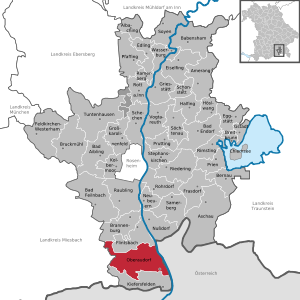
| County : | Rosenheim | |
| Height : | 479 m above sea level NHN | |
| Area : | 59.3 km 2 | |
| Residents: | 5236 (Dec. 31, 2019) | |
| Population density : | 88 inhabitants per km 2 | |
| Postal code : | 83080 | |
| Area code : | 08033 | |
| License plate : | RO , AIB , WS | |
| Community key : | 09 1 87 157 | |
| Community structure: | 38 districts | |
| Address of the municipal administration: |
Kufsteiner Strasse 6 83080 Oberaudorf |
|
| Website : | ||
| Mayor : | Matthias Bernhardt (FWO) | |
| Location of the municipality of Oberaudorf in the district of Rosenheim | ||
  |
||


Oberaudorf is a municipality in the Upper Bavarian district of Rosenheim . The climatic health resort belongs to the planning region of Southeast Upper Bavaria .
geography
Oberaudorf is located in the Bavarian Prealps and the Bavarian part of the Lower Inn Valley . Oberaudorf and Niederaudorf are separated by the course of the western Inn tributary Auerbach .
Community structure
There are the districts Niederaudorf and Oberaudorf. The municipality of Oberaudorf has 38 officially named districts:
history
Until the church is planted
Traces of settlement in the Audorf district go back to the Bronze Age . The place is mentioned for the first time in 780 as an original village in a deed of gift to the Freising Monastery . The Bavarian dukes succeeded in ousting the lords in Mangfallgau , the Counts of Falkenstein , from their possessions and dominions from 1244 and in expanding their own rule in the Inn Valley. The Auerburg above Oberaudorf is mentioned for the first time in the Wittelsbach house contract of Pavia in 1329. Around 1350 the Auerburg was mentioned as a court and official seat of a caretaker . Since the 15th century, the judicial district has been divided into the main teams Kiefersfelden, Nieder- and Oberaudorf and Fischbach. After the Landshut War of Succession (1503–1505) the courts of Kufstein, Kitzbühel and Rattenberg were lost to the Habsburgs . The Auerburg was from now on border fortress to Tyrol and was reinforced accordingly. In the Austrian War of Succession , Austrian troops captured Oberaudorf and the Auerburg on May 4, 1743. After the Peace of Füssen in 1745, the fortress was razed by Kitzbühel miners in 1747. The Napoleonic era brought numerous troop marches, but no fighting in the village. In the course of the administrative reforms in Bavaria , the municipal edict of 1818 created the municipalities of Ober- and Niederaudorf.
19th and 20th centuries
In 1848 the abolition of upper ownership and the patrimonial courts caused upheavals. From the middle of the 19th century, the place was discovered as a summer resort by the first holidaymakers. In 1857 it was connected to the new Rosenheim – Kufstein line . In 1868 the previous Catholic vicariate became its own parish. Large fires in 1823 and 1857 led to brisk construction activity. The place was still affected by air raids in the last days of the Second World War , as the Wehrmacht was still facing the American soldiers with the last of their strength. From 1988 to 1992 the Oberaudorf-Ebbs power plant was built on the Inn .
Incorporations
The population of the municipalities of Oberaudorf and Niederaudorf decided in a referendum on November 22, 1970 to merge the municipalities, which took place on April 1, 1971. Part of the Niederaudorf community was reclassified to the Flintsbach am Inn community.
Population development
Between 1988 and 2018, the municipality grew from 4,475 to 5,264 by 789 inhabitants or by 17.6%.
- 1970: 3571 inhabitants
- 1987: 4,373 inhabitants
- 1991: 4704 inhabitants
- 1995: 4816 inhabitants
- 2000: 4692 inhabitants
- 2005: 4768 inhabitants
- 2010: 4948 inhabitants
- 2015: 5033 inhabitants
politics
mayor
Mayor is Matthias Bernhardt (Free Electorate of Oberaudorf). He prevailed in the local elections on March 15, 2020 with 68.1% of the vote against two competitors. Due to a vacancy in the first mayor's post, Bernhardt took up his post on April 1st and not on May 1st, 2020. He is the official successor of Hubert Wildgruber (CSU, Mayor from 2002 to 2020), who was no longer available for election in 2020 for health reasons. Wildgruber succeeded Alois Brunner (CSU) in 2002.
coat of arms
The coat of arms of Oberaudorf shows "a red-armed golden falcon with a red collar standing in blue on a golden three-mountain, ready to fly." It was awarded by the State Ministry of the Interior in 1921 and is based on early local history. The falcon was the talking shield image of the County of Falkenstein, which died out around 1272 .

Attractions
- Ruins of the Auerburg with the castle museum
- Parish church to U. Lb. Frau Oberaudorf
- Filial church St. Michael Niederaudorf
- Reisach Monastery
- Urfahrn Castle
- Historic inn: Weber on the wall
- Seebach Records company premises

Economy and Infrastructure
Economy including agriculture and forestry
In 1998, according to official statistics, there were 19 employees in the field of agriculture and forestry, 221 in the manufacturing sector and 294 in the trade and transport sector at the place of work. In other economic sectors 728 people were employed at the place of work subject to social security contributions. There were a total of 1281 employees at the place of residence subject to social insurance contributions. There were 16 companies in the main construction trade. In addition, in 1999 there were 75 farms with an agriculturally used area of 1655 ha, of which 37 ha were arable land and 1608 ha were permanent green space.
Leisure and Tourism
Oberaudorf is an important climatic health resort and winter sports area in the Bavarian Inn Valley. In addition to an extensive network of hiking, biking and touring trails, the place offers guests and residents a ski jump, toboggan runs, a chairlift, cross-country skiing trails and ski lifts (with snow-covered slopes) and in summer through the surrounding lakes with a beach volleyball court and the Luegsteinsee lido with a giant water slide and white water Auerbach good opportunities for recreation and leisure activities. The newly designed Hocheck leisure area also has an alpine summer toboggan run. Germany's largest floodlight system for skiers and snowboarders is in operation on the Hocheck in winter. The toboggan run there is also illuminated in the evening.
In 2017, 75,411 guests spent a total of 215,669 nights in Oberaudorf.
Between 1999 and 2011 there was also the possibility of taking a passenger ship on the Inn from Oberaudorf via Niederndorf , Ebbs , Kiefersfelden to Kufstein from May to October .
Sports
In the district of Tatzelwurm, a natural toboggan run is built annually , on which German and Bavarian championships in natural tobogganing are held. With the Kahlanger-Schanze there is a normal hill formerly also used for international jumping. The Hocheckschanzen, which are also available, are still used today for children and youth training.
Transmitter Oberaudorf
To improve the supply of the lower Inn Valley from Brannenburg to the state border, a filling transmitter was built on the Schweinberg. This broadcasts the following radio stations:
|
Frequency [MHz] |
program | RDS PS | RDS PI | Regionalization |
ERP [kW] |
Antenna pattern round (ND) / directional (D) |
Polarization horizontal (H) / vertical (V) |
|---|---|---|---|---|---|---|---|
| 94.6 | Antenna Bavaria | ANTENNA | D318 | - | 0.3 | D. | H |
| 104.2 | Radio Charivari Rosenheim | CHARI | DC1B | Rosenheim (country) | 0.3 | D. | H |
traffic
- Road traffic: Oberaudorf has its own junction on the Inntal motorway A 93 (Rosenheim − Kiefersfelden).
- Rail traffic: Oberaudorf has a stop on the Rosenheim – Kufstein railway line .
- Bus traffic: Oberaudorf is connected to the regional traffic of Upper Bavaria through line 52 and the Wendelstein ring line (only runs between May and November) . Line 52 connects Oberaudorf with Rosenheim , Flintsbach am Inn , Kufstein , Kiefersfelden , Raubling and Brannenburg , while the Wendelstein ring line connects the place with Bayrischzell , Fischbachau and Bad Feilnbach . There is also a night bus route (N5) in the direction of Rosenheim or Kufstein on weekends.
education
There are the following facilities:
- Kindergartens: 190 kindergarten places in two kindergartens
- Primary schools: a state with 11 teachers and 137 students; a private primary school with about 40 students and a private middle school (under construction) with currently (November 2016) 14 students.
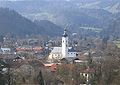
View from the Auerburg to Oberaudorf

View from the Auerburg to Oberaudorf, in the background the wild bars

Chapel on the Florianiberg, in the background the Tame Kaiser

Castle gate
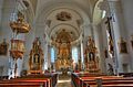
Parish church Oberaudorf

Reisach Monastery


Personalities
- Volker Banfield (* 1944), pianist
- Hans Berger (* 1944), musician
- Joachim Berthold (1917–1990), sculptor, lived and died in Oberaudorf
- Friedrich Wilhelm von Bissing (1873–1956), Egyptologist
- Magnus Freiherr von Braun (1878–1972), lawyer and politician
- Susanne Breit-Keßler (* 1954), publicist, theologian, regional bishop of Munich-Upper Bavaria
- Eduard Brenner (1888–1970), Anglicist, education politician, initiator and long-time head of the Oberaudorfer Kreis
- Anne Cyron (* 1955), politician (AfD)
- Klaus Eidam (1926–2006), dramaturge and librettist, lived and died in Oberaudorf
- Bartholomäus Grill (* 1954), journalist, writer, Africa expert
- Wolfgang Hammer (* 1946), educator, specialist book and novelist
- Marinus Kraus (* 1991), ski jumper
- Johannes Neuhäusler (1888–1973), Catholic theologian and auxiliary bishop, 1913–1917 chaplain in Oberaudorf
- Ernst Sachs (1867–1932), Oberaudorf honorary citizen, inventor of the "torpedo freewheel hub", co-founder of Fichtel & Sachs (Schweinfurt) and developer of the Sachs engine.
- Willy Sachs (1896–1958), honorary citizen of Oberaudorf, sole owner of Fichtel & Sachs
- Hubert Schwarz (* 1960), Olympic champion with the relay in the Nordic combined in 1988 and two-time German champion in ski jumping (1979 and 1981 K90 respectively).
- Bastian Schweinsteiger (* 1984), national soccer player; Hometown
- Tobias Schweinsteiger (* 1982), soccer player; Hometown
- Edmund Stoiber (* 1941), Bavarian Prime Minister from 1993 to 2007
- Sepp Wildgruber (* 1959), ski racer
Web links
- Entry on the coat of arms of Oberaudorf in the database of the House of Bavarian History
Individual evidence
- ↑ "Data 2" sheet, Statistical Report A1200C 202041 Population of the municipalities, districts and administrative districts 1st quarter 2020 (population based on the 2011 census) ( help ).
- ↑ Oberaudorf. Bayerische Landesbibliothek Online, accessed on February 13, 2018 .
- ↑ Oberaudorf municipality: Historical development. Accessed February 24, 2017.
- ^ Wilhelm Volkert (ed.): Handbook of Bavarian offices, communities and courts 1799–1980 . CH Beck, Munich 1983, ISBN 3-406-09669-7 , p. 561 .
- ^ Matthias Bernhardt before taking office: From professor to mayor in Oberaudorf. OVB online, March 16, 2020.
- ↑ Descent stopped during the duration of the stay. OVB online, February 13, 2018, accessed on February 13, 2018 .
- ↑ Inn shipping finally ceased. ORF.at, December 9, 2011, accessed on February 13, 2018 .
- ^ Image of the station Oberaudorf on the page of Heinz Schulz, Frankfurt am Main.
- ↑ Station database of the Bavarian Railway Company, Oberaudorf station

Albaching | Amerang | Aschau im Chiemgau | Babensham | Bad Aibling | Bad Endorf | Bad Feilnbach | Bernau am Chiemsee | Brannenburg | Breitbrunn am Chiemsee | Bruckmühl | Chiemsee | Edling | Eggstätt | Eiselfing | Feldkirchen-Westerham | Flintsbach am Inn | Frasdorf | Griesstätt | Großkarolinenfeld | Gstadt am Chiemsee | Halfing | Höslwang | Kiefersfelden | Kolbermoor | New building | Nussdorf am Inn | Oberaudorf | Pfaffing | Prien am Chiemsee | Prutting | Ramerberg | Raubling | Riedering | Rimsting | Rohrdorf | Rott am Inn | Samerberg | Schechen | Schonstett | Söchtenau | Soyen | Stephanskirchen | Tuntenhausen | Vogtareuth | Wasserburg am Inn
Unregulated areas in the district of Rosenheim
Rotter Forst-Nord |
Rotter Forst-Süd