
Munich gravel plain

The Munich gravel plain is a sander in Upper Bavaria that was formed over several ice ages . Compared to other ice-age sands with short, steep transition cones and the course through narrow valleys in the Alpine foothills , it is characterized by its very spacious extension.
location
The Munich gravel plain forms an approximately 1,500 km² triangle. The approximate corner points are Weyarn (between Miesbach and Holzkirchen ) in the southeast, Moosburg an der Isar in the northeast and Maisach in the west. The eponymous city of Munich and almost the entire surrounding district are also located in the flat gravel plain, which is why the city has a very low-profile topography in contrast to the surrounding districts in the north, south and west . The plain drops to the northeast from initially around 700 m above sea level to around 400 m ; this has made a decisive contribution to the formation of the large Dachau fens , the Freisinger Moos and the Erdinger Moos . The greatest layer thickness of the gravel is around 100 m in the south of Munich; it also decreases to the north.
Emergence
The time of origin extends over three ice ages, which can still be identified today in the stratification.
The glaciers fed by the Central Alps, which almost reached as far as Munich, transported not only water but also large amounts of soil and rock into the Alpine foothills . When the glaciers melted at the beginning of the warm periods , these gravel and water masses were released and washed north, where they were mainly deposited in the Munich gravel plain. In the bottom layer, for example, there are solidified deposits from the Mindel glacial period , on top of which lies gravel from the Riss glacial period , which is finally replaced by the youngest layer, the debris from the Würm glacial period . In between there are layers of clay that originate from the respective interglacial period and represent the interim accumulations of humus. The ice-age gravel lies on top of the groundwater-retaining sediments of the upper freshwater molasse, which was formed when rubble from the young Alps filled the molasse basin formed by the thrust of the continental plates 50-2.6 million years ago ( Tertiary ). These layers are known locally as Flinz (Flinzsande, Flinzmergel).
The gravel, which stands in contrast to the cutting into many Alpine foreland rivers and the associated terracing , was caused, among other things, by the raising of the Landshut threshold.
Waters
The Ur- Mangfall once flowed through the east of today's Munich gravel plain during the Ice Age, before it lay behind a Worm Ice Age moraine and was diverted to the East towards the Inn . The Grub-Harthausen dry valley is evidence of the former course of the river .
Today the Isar is the most important body of water on the Munich gravel plain. It divides the plain from southwest to northeast into two roughly equal halves. The Würm flows from the district of Starnberg Coming through the west of the Munich gravel plain. Another natural flowing body of water is the Hachinger Bach , which is often said to be the only flowing body of water that has its source in the Munich gravel plain. However, this also applies to the Gröbenbach and its tributaries, which are mainly located in the Aubinger Lohe .
Groundwater situation
In the southern part, the gravel layer of the Munich gravel plain, which is rich in groundwater, is very thick. The uppermost groundwater layer is more than 13 m below the ground at the Haar-Eglfing measuring point, in Kirchheim it is around 5 m and on the northern edge of the Munich gravel plain it is less than 1 m. The groundwater level used to be even higher; The Erdinger Moos , which begins north of the communities of Aschheim , Kirchheim and Pliening , was once a spring moor where the groundwater came to light. The outlying communities were flooded during heavy rainfall in the north. This was remedied by the interception ditch that was built in the early 1920s, but this caused the groundwater to drop significantly, so that new wells had to be dug in the communities mentioned.
The thickness of the gravel layer in the south of the Munich gravel plain made it not very easy for the people who settled there in the early Middle Ages to access the groundwater, which was necessary because there was no surface water. People settled around the wells there, and the places were named after the owners of the wells, for example Putzbrunn (once Puzzoprunnin after a Puzzo), Grasbrunn (Gramasprunnin after a Gramas or Graman) or Siegertsbrunn (early names Sigihartasprunnin after a Sigihart ).
Economical meaning
The gravel lying close below the surface is ideal for mining; Currently (2019) there are still several gravel works at Planegg , Grasbrunn and Aschheim, among others . Former gravel pits are also the Heimstettener See , which was used by the Reichsbahn until 1937, the Feringasee , whose gravel was used in the construction of the A 99 , the Böhmerweiher , which was created during the construction of the A 8 , the Dreiseenplatte with Lerchenauer See, Fasanerie- Lake and Feldmochinger See in the Munich district of Feldmoching-Hasenbergl, which were created when gravel was extracted for construction work in the 1930s, and finally the Langwieder Lake District in the west of Munich. The Langwieder Seenplatte includes the Langwieder See, which supplied gravel for the construction of the A8 motorway in the 1930s, the Birkensee, from which gravel was removed for a railway line in 1938, and the Lußsee, from which gravel was used for the construction of the 1995 to 2000 Eschenrieder Spange , a section of the A 99, was won. The agricultural use takes place today with approx. 100 full-time farms v. a. in the Munich green belt .
Gravel is also extracted in the western and northern district of Erding , between Erding, Eitting and Berglern . The Kronthaler Weiher was begun in 1965 and with 22 hectares of area, the largest Stretch of the district.
Varia
During construction work for the Munich subway, a cavity formed in the gravel, into which an entire public service bus collapsed in 1994 ( Trudering bus accident ).

The gravel plain is level and slopes only slightly to the north
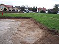
The humus cover is
approx. 40 cm thick
Humus on gravel

Field near Ottobrunn


Individual evidence
- ^ Bavarian flood news service. State Office for the Environment Archived copy ( memento of the original dated August 22, 2006 in the Internet Archive ) Info: The archive link has been inserted automatically and has not yet been checked. Please check the original and archive link according to the instructions and then remove this notice. .
- ^ Bavarian flood news service. State Office for the Environment Archived copy ( memento of the original dated August 22, 2006 in the Internet Archive ) Info: The archive link has been inserted automatically and has not yet been checked. Please check the original and archive link according to the instructions and then remove this notice. .
- ↑ merkur.de: Kronthaler Weiher
Web links
- Groundwater model Eastern Munich gravel plain (PDF; 10.2 MB)