
Grobenbach
|
Gröbenbach upper course: Holzbach |
||
 Catchment area of the Gröbenbach between Amper and Würm. The most important elevations are shown in brown. |
||
| Data | ||
| Water code | DE : 16452 | |
| location |
Bavaria
|
|
| River system | Danube | |
| Drain over | Amper → Isar → Danube → Black Sea | |
| origin | west of Germering 48 ° 7 ′ 53 ″ N , 11 ° 20 ′ 22 ″ E |
|
| Source height | approx. 538 m above sea level NHN | |
| muzzle | from the right and south-southwest in Dachau in the Amper coordinates: 48 ° 15 ′ 36 ″ N , 11 ° 26 ′ 29 ″ E 48 ° 15 ′ 36 ″ N , 11 ° 26 ′ 29 ″ E |
|
| Mouth height | approx. 476 m above sea level NHN | |
| Height difference | approx. 62 m | |
| Bottom slope | approx. 2.9 ‰ | |
| length | 21.7 km | |
| Catchment area | 128.59 km² | |
| Discharge at the Dachau gauge |
MNQ MQ MHQ HHQ (2005) |
1.02 m³ / s 1.65 m³ / s 6.62 m³ / s 7.85 m³ / s |
 Gröbenbach in Dachau |
||
The Gröbenbach is a right tributary of the Amper in the town of Dachau in the Upper Bavarian district of Dachau, about 22 km long, together with its upper course Holzbach .
course
The Gröbenbach and most of its tributaries ( Erlbach , Fischbach , Langwieder Bach ) arise at the foot of the Parsberg ( 569 m above sea level ) and the Aubinger Lohe ( 541 m above sea level ), where layers of groundwater ( Flinz ) come to the surface . The Gröbenbach itself rises as a Holzbach near the Germeringer See in the area of the city of Germering . It then flows through Puchheim and Gröbenzell , where in parts it forms the border with the state capital Munich . The Gröbenbach continues through the western Dachauer Moos on the edge of the district of Olching and through the districts of Eschenried and Gröbenried of the Bergkirchen community to Dachau , where a level station for the Munich water management office is located about 250 m north of the B 471 . Shortly before it flows into the Amper , a large part of the water in Dachau is drained off. This flows in the bed of the Dachau-Schleissheim Canal first to the east and then over the Pollnbach in the Dachau district of Polln into the Würm , which shortly afterwards, like the Gröbenbach, flows into the Amper from the right.
Regular drought in the late 2010s mean that the headwaters of the Gröbenbach have shifted by a few hundred meters. An outflow from the Germeringer See, which used to be just one of several tributaries to the stream, must now be viewed as a new source. The bed upstream will be dry in 2020.
Tributaries
Origin of the initially Holzbach called Gröbenbach west of Germering .
- Passes the Germeringer See on the left bank, 2.5 ha
- Krautgartengraben , from the right to Puchheim -Ort
- On the Plany , from left to the Marienkapelle near Puchheim train station
- Kleine Mauken , from the right on the city limits of Munich
- Große Mauken , from the right on the Munich city limits opposite the Puchheim golf course
- Mühlstetter Graben , from the left from Puchheim
- Weihergraben , from the right at the triangle Munich / Puchheim / Gröbenzell
- Kleiner Ascherbach , from the left before the center of Gröbenzell
- Erlbach , from the right near Munich-Freiland, 6.1 km and 25.8 km²
- Scharinnenbach , from the right at the triangle Munich / Gröbenzell / Bergkirchen
- Fischbach , from the right at Bergkirchen-Birkenhof, 5.8 km with the upper course Lohwiesengraben and 4.0 km²
- Schwefelgraben , from the right on the golf course near Eschenried , Bergkirchen municipality
- Langwieder Bach , from the right at the beginning of Bergkirchen- Gröbenried , 6.6 km and 20.0 km²; also fed from the upper reaches of the Lohwiesengraben of the Fischbach
- Krebsbach , from the right near Waldschwaige , Karlsfeld municipality
- → (junction of the Dachau-Schleißheim Canal ), to the right at Schleißheimer Straße in Dachau - Obermoosschwaige
Mouth of Gröbenbachs from the right and south into the Amper after the river bridge at Martin Huber Street in Dachau.
Character and environment
The Gröbenbach, originally a meandering meadow and moss creek, has now been straightened and canalized almost in its entire course.

Only between Puchheim and Puchheim train station were renaturation measures carried out on a stretch of several hundred meters. The large map of Bavaria by Philipp Apian , created around 1560, suggests that the upper reaches of the Gröbenbach originally merged into the Ascherbach and already flowed into the Amper near Feldgeding , a district of the Bergkirchen municipality. The topographical atlas of the Kingdom of Bavaria from 1812 shows the Gröbenbach in its current course, but still uneven. According to this map, a straight canal to the Würm (formerly "Groeben Canal") began roughly where the Gröbenbach now crosses under the A8 federal motorway . The course of the now filled canal bed is, however, still marked by the strikingly straight course of the Munich city limits in this section.
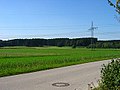
Headwaters of the Gröbenbach below the Parsberg near Germering
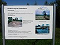
Notice board on the renaturation in the area of Puchheim

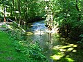
Gröbenbach near Puchheim
Gröbenbach in Puchheim train station

Gröbenbach in Gröbenzell (crossing under the Munich – Augsburg railway line )

The Langwieder Bach flows into the Gröbenbach near Gröbenried

Gauge station in the south of Dachau
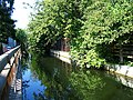
Diverting the Gröbenbach into the Schleissheim Canal

Inflow An der Plany shortly before the confluence with the Gröbenbach


Individual evidence
- ↑ a b Height after query (with right click) on the BayernAtlas. See the → web links .
- ↑ Length according to: Directory of brook and river areas in Bavaria - Isar river area, page 57 of the Bavarian State Office for the Environment, as of 2016 (PDF; 2.5 MB) (number of pages may change)
- ↑ Catchment area according to: List of brook and river areas in Bavaria - Isar river area, page 57 of the Bavarian State Office for the Environment, as of 2016 (PDF; 2.5 MB) (number of pages may change)