
Hachinger Bach
| Hachinger Bach | ||
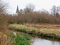
 Hachinger Bach near Unterbiberg |
||
| Data | ||
| Water code | EN : 1662 | |
| location | District and City of Munich | |
| River system | Danube | |
| Drain over | Hüllgraben → Abfanggraben (Munich) → Mittlere-Isar-Kanal → Isar → Danube → Black Sea | |
| source | in Oberhaching -Deisenhofen 48 ° 1 '16 " N , 11 ° 35' 41" O |
|
| Source height | approx. 570 m above sea level NN | |
| aboveground end | North of the Ostpark in Munich Coordinates: 48 ° 7 '12 " N , 11 ° 37' 58" E 48 ° 7 '12 " N , 11 ° 37' 58" E |
|
| Mouth height | approx. 530 m above sea level NN | |
| Height difference | approx. 40 m | |
| Bottom slope | approx. 3.3 ‰ | |
| length | 12 km | |
| Big cities | Munich , boroughs: Ramersdorf-Perlach , Berg am Laim | |
| Communities | Oberhaching , Taufkirchen , Unterhaching , Neubiberg | |
| Residents in the catchment area | approx. 100,000 | |
The Hachinger Bach is the only river that has its source, on the right of the Isar, within the Munich gravel plain. It flows south of Munich through the villages of Oberhaching , Taufkirchen , Unterhaching and Unterbiberg and enters the Munich urban area in Perlach . From the infiltration point in Berg am Laim, it flows underground through a pipe. It is almost twelve kilometers long.

Geological origin
Conditions of the last ice age

The Hachinger Bach was created next to the Isar in the second former meltwater drainage channel of the Wolfratshausen lake , which has now disappeared , a former glacial lake of the Isar-Loisach glacier from the last Ice Age ( Würme Ice Age ). It is the eastern, so-called Eglinger Glacier Finger, which advanced on the Egling - Ascholding - Deining line (Fig.). Like other meltwater, the Hachinger Bach washed away the softer layers from the preceding ice ages of the Tertiary , creating space for the formation of a new gravel plain . The resulting Gleißental in the south of the Hachinger Valley is the original southern drainage channel that flowed into today's Hachinger Bach and fell dry postglacial. The valley furrow from Deisenhofen extends into the gravel. This incision exposes the groundwater level, so that the stream bed, which is slightly lower than the groundwater level, continually flows into the groundwater. After the end of the Würme Ice Age, the brook deepened and created the terrace along today's Oberhaching-Taufkirchen road.
Hachinger barrier layer

In some places in the upper reaches of the Hachinger Bach, the groundwater reaches the surface of the earth, where it emerges as a brook (Fig.). The sources of the Hachinger Bach are caused by a quaternary, small-scale river marl layer ( Hachinger barrier layer ) (Fig.). This upper barrier layer was created by late glacial fluvial clay and silt deposits as a result of meandering meltwater runoff from a forerunner of the Hachinger Bach. Under the Haching barrier layer, however, there is a larger area of the tertiary (up to 2.58 million years ago ) Flinzmargel barrier layer (Fig.), Which acts as a groundwater reservoir - with a simultaneous local reduction in the thickness of the Quaternary (up to 11,700 years ago or up to End of the last Ice Age) loose sediments, so that here - depending on the water pressure from the south - more or less groundwater sometimes comes to the surface in a diffuse manner. The whitish, 30–40 cm thick river marl layer, as it can be observed in the area of the Taufkirchener Feuchtwiese , lies above the darker, Würm Ice Age, in the upper area of the Hachinger Bach only 7–10 meters thick low-terrace gravel. At the end of the last ice age 10,000 years ago, the stream flowed with significantly more water from the terminal moraine landscape near Deining through the Gleißental and the Hachinger valley basin and thus flowed further north than today, until it only merged with the Isar in the north of what is now Munich .
Today's stream course
The Hachinger Valley, which runs from south-south-west to north-north-east, and the Hachinger Bach that runs through it, lie in the south-eastern part of the Munich gravel plain.
origin
Today's source of the Hachinger Bach lies between the districts of Deisenhofen and Oberhaching, where the Gleißental coming from the Deininger Weiher , which only carries groundwater but no surface water, becomes the Hachinger Tal. Over a length of around 100 m, the groundwater that escapes from the Hachinger barrier layer makes the ground more and more moist until a small stream has formed. Since the groundwater level fluctuates greatly, there is no clear source. To prevent the stream from falling completely dry, groundwater is pumped from a well about 4 meters deep next to a park path and fed into the young stream bed with a pipe. The groundwater level has been falling since Munich built wells in the Deisenhofen Forest in the early 1970s to supply the city with water. This leads to an increasingly sustained feed-in of groundwater in Oberhaching.
Upper and middle course of the stream
In the upper course around its origin in Deisenhofen , the brook runs through a relatively narrow valley with a width of 100-800 meters with steep valley flanks up to 15 meters high. The width of the valley widens in Taufkirchen with flatter slopes to approx. 1.5 km and then levels out completely. The bottom of the stream and the upper edge of the groundwater are roughly at the same height between the source area and Taufkirchen. On its way to Furth, Potzham and Taufkirchen, the brook constantly gains groundwater. At Westerham it reaches its maximum water flow. Between Potzham and Taufkirchen Süd the brook develops a natural section in the area of the protected wet meadows, some of which are several meters wide. It then flows through the communities of Unterhaching and Unterbiberg , the district of Unterbiberg of the community of Neubiberg and Ramersdorf-Perlach . After the underpass of the A8, the stream flows almost completely natural between agricultural areas in the direction of the church of Unterbiberg (see photo in the info box on this page), only to be narrowed to a width of only 60 cm shortly afterwards (crossing Unterbiberg). Further groundwater access and tributaries are the Mühlbach, which begins in the motorway pond and flows into the Hachinger Bach on the northern edge of Potzham, the Entenbach near Taufkirchen and other streams and ditches on the southern edge of Taufkirchen. They let the amount of water increase a little.
Lower course of the stream and seepage
The flake layer sinks significantly north of Unterhaching and with it the groundwater. This drop, which measures 20 meters over a length of 1.5 km, has been known as the "underground rapids" or "underground waterfall". Because of the heavy drop in the flax layer, the stream would have to seep into the gravel of the Munich gravel plain there. Since it has created a dense bed for itself through its own mud deposits, the stream continues to the southern border of Munich. In the urban area, the creek runs largely in an artificial creek bed through the district of Perlach, then flows further along the western edge of the Ostpark to its former natural infiltration point in Berg am Laim in about the middle of Kampenwandstrasse on the border of the Perlach and Berg am districts Laim , after having crossed Heinrich-Wieland-Strasse from the Ostpark. At the infiltration point, only about a quarter of the amount of water is measured at around 130 liters / second compared to Westerham (Taufkirchen) with 440 liters / second, due to the seepage that had already occurred.
In 1933, an inlet structure with an automatic dirt rake and infiltration basin was built in Kampenwandstraße directly on Heinrich-Wieland-Straße. In the course of the underground construction at the end of the 1970s, the intake structure was relocated in 1981 and the infiltration basin established at the time was filled. Today, the P + R parking lot of the Michaelibad underground station is located in the immediate vicinity . The intake structure with a newly created infiltration basin was relocated 120 m further north in Kampenwandstrasse. Today, the infiltration basin only serves to collect the water that the intake structure can no longer absorb during flooding, in order to prevent flooding. Since 1933 the brook has been led underground from this point through a concrete pipe to the Zamdorfer Gleisdreieck south of the A 94 at the southern tip of the Munich district of Bogenhausen and feeds the enveloping ditch that begins there . The pipe initially runs under Kampenwandstrasse, turns east on Hachinger-Bach-Strasse to St.-Veit-Strasse, under which it runs northwards under the Munich East marshalling yard to the confluence with the Hüllgraben. The enveloping ditch flows in the Johanneskirchener Moos into the interception ditch , which flows into the Middle Isar Canal at the Neufinsing power station . The height difference of the Hachinger Bach is 39 meters from the source to the infiltration. This corresponds to a gradient of 3.4 per thousand.

Settlement history
Bronze age
The name of the brook is derived from the Bavarian Hacho , who built settlements along the course of the brook between the 5th and 8th centuries. Because of its abundance of fish, it was also called trout or Ferchenbach. The Hachinger Tal proves to be a prehistoric and early historical settlement area. The oldest evidence of the presence of humans is a 5,500-year-old copper ax found on an Unterhaching field. In and around Taufkirchen, especially south of the sports and leisure park, excavations were carried out in 1994 from the Neolithic Age (around 4500–1800 BC), the Bronze and Urnfield Age (around 1800-750 BC), the Hallstatt Period ( around 800–450 BC) and La Tène period (around 750-15 BC), the Roman period (15 BC – 5th century AD), Germanic finds and finds the early Middle Ages (5th - 8th centuries AD) - on the cone fields, among other things, a burial ground of the bell-cup culture (around 2000 BC), the earliest evidence of settlement in the Hachinger Valley so far. A Celtic settlement from 600 BC. Until about the middle of the 3rd century BC. BC with numerous residential and storage buildings, rows of fences, storage and waste pits as well as fireplaces could be reconstructed. In addition, the remains of a Roman villa rustica, a manor based on the Roman model, were exposed. The finds in Taufkirchen are among the oldest in southern Bavaria.
Post-Roman times and early Middle Ages
In 2005 an "archaeological find of the century" was made in Unterhaching. Ten burials from around 500 AD were found there with unusually rich additions such as garnet-set gold and silver jewelry in the women's graves.
In 1999, early medieval grave finds from various epochs from AD 100–450 were found in Perlach. The excavations were carried out on behalf of the Horticultural Department of the City of Munich under the supervision of the Bavarian State Office for Monument Preservation. The finds include a Roman manor whose posts, pits, cellar, oven and fence trenches have been preserved as discoloration in the ground, as well as a watermill located west of the current bed of the stream (already excavated in 1995), a clasp, iron fittings and ceramics as well as a cemetery at 30 Body burials from post-Roman times.
The early settlement can be traced back to the stream. The Hachinger Tal became an important north-south connection from the Danube to the Alps. The road was taken over by the Celts and Romans . The name Taufkirchen is reminiscent of an old baptismal font right by the stream. In early Christian times people were baptized in a full-body baptism directly by the stream in a baptistery that only contained a baptismal font or a baptismal font .
Middle Ages and Modern Times
The bailiff in Taufkirchen was not only a judge in the village court, but also supervised the economically important Hachinger Bach. In the hall book it says: "The pach I [the Hofmarkherr] have to open [damming] and Wessern every Saturday at Vespers time to Sundays at Vespers time and lent them to the residents of the Hoffmarch and my leftovers." The residents of the former Hofmark Taufkirchen were allowed to take water for irrigation from the stream free of charge. The Angermüller in Winning, on the other hand, had to pay "water money" to irrigate his meadows. The brook was of great importance for the drinking water supply of humans and animals. Because of its abundance of fish, Duke Wilhelm IV bought the brook outside the Hofmark from the Taufkirchener including the Hofanger for 315 florins .
Since it was impossible to explain its seepage in earlier times, there were some legends around the Hachinger Bach in which the devil is held responsible for the brook's disappearance. Other variants deal with a mill by the stream, about which there should have been an inheritance dispute between two sons. Because they could not come to an agreement, God let the stream in front of the mill dry up, so that the mill became useless. More than a dozen former mills are noted along the stream. Of the original five mills in Taufkirchen and Potzham, two were still in operation after the Second World War, of two the buildings (Bachmühle, Sixtmühle) are still standing, and some of the former branches of the brook for mill wheel operation. In Perlach, fragments of Roman millstones and the remains of a mill were found several hundred meters west of the current course of the stream. (see also: Mühlen am Hachinger Bach ).
In Unterhaching and Perlach there used to be bulges on the edge of the brook as horse pools for watering and washing horses. In Unterhaching women washed their laundry at 15 piers by the stream until after the Second World War.
High and low tide
Floods of the Hachinger Bach occurred repeatedly. In the description of the brook from 1820 it is stated that there are seasons when the brook extends over the whole valley and often floods the area for more than a whole year with the result that the meadows could not be cultivated. A major flood was reported in 1940. The most recent flood was on Whitsun 2013. The four district communities on the Hachinger Bach are working on concepts to prevent flood damage, such as retention basins . In other years the creek could fall completely dry. In 1866 a flow rate of 1.1 m 3 was measured in the Perlach town center , compared to 30 m 3 in Taufkirchen (church) in 1875. Another dry year with a lack of water in the entire gravel plain was 1972. As a curiosity, the Hachinger Bach can be seen from the bottom to freeze over. Even with normal water flow , the water can overflow from such ground ice and lead to widespread flooding. In 2016, the city of Munich, in coordination with the neighboring communities of Oberhaching, Taufkirchen and Unterhaching, plans to award a study for a groundwater model for the Hachinger Bach. One of the scenarios that could be implemented is to set up retention areas (flood areas) in the creek communities south of Munich , which is intended to reduce the flood risk in the urban area of Munich.
Today around 100,000 people live in the catchment area of the Hachinger Bach.
Mills on the Hachinger Bach

The following mills are listed at the Hachinger Bach:
- Mangmühle in Furth / Potzham, burned down by Sweden in 1544, 1643
- Sutner, Kottmühle in Potzham, 1462, grinding mill and sawmill ( grist mill ), expansion as a dam power station with Francis turbine , shutdown in 1965
- Ferstl, Bachmühle in Taufkirchen, 1544, grinding mill, water power machine with surge operation, shut down in 1969
- Stumpf, Sixtmühle in Taufkirchen, 1465, water-powered sawmill, no longer in operation after 1945
- Kiermeier, Obermühle and Bäckermühle in Unterhaching, 1862, Mahlmühle and from 1925 also electricity generation, shut down in 1972
Other mills mentioned are:
- Fence Mill in Westerham, 1465
- Untermühle in Unterhaching, 1426
At the turn of the 1900s, other mills are likely to have been in operation.
Diversions and renaturation
Like almost all rivers in Germany, the Hachinger Bach was regulated in the past and diverted according to needs, e.g. B. to irrigate adjacent meadows and to operate seven mills that could work even in winter. In the center of Perlach, the stream was straightened from 1897 and concreted in as a way of improving the town at that time. Since 1948, a large-scale diversion has led several hundred meters around the Neubiberg air base. In the meantime, longer sections of the stream bed have been renatured, for example in the Hachinger Tal landscape park on the former airfield site.
In 2004, in Potzham, west of the bridge at Mühlweg, a previously existing floor fall in the form of a barrier at a height of around 70 cm was converted into a floor ramp with several small steps in the creek bed. This measure enables animals to use the stream more consistently. In Taufkirchen, three phases of renaturation of the Hachinger Bach along Münchner Strasse took place between 2006 and 2008 with the aim of increasing the leisure and recreational value. The measures included a partial relocation of the course of the stream and a sloping front structure of rough-set armourstones. The existing granite stone wall was mainly integrated into the newly designed embankment through the bank porch. The stream was partially relocated. This achieved a more natural design of the bank and embankment areas and created more varied flow structures. In 2009 another section of the street "Am Heimgarten" was renatured downstream.
In its lower reaches, the brook originally branched out into eight branches at the level of the Munich districts of Ramersdorf, Perlach, Berg am Laim. Because of floods, attempts have been made since the end of the 19th century to specifically let the stream seep into Berg am Laim. This project was implemented in 1933 with the commissioning of the local infiltration system and the stream was piped underground as it continued. Since the 1980s, the residents of Berg am Laim have repeatedly asked for the 3.8 km long section of the stream between Ostpark and Hüllgraben to be relocated to the surface. From the inlet structure to the pavilion of the Josephsburg underground station on Kreillerstraße, the dry stream bed already partially exists. The City Council of Munich issued the official project approval including the financing commitment in 2014. The required plots still have to be acquired. In 2017, the City of Munich reached an agreement with the owners that the 14-hectare park project in Berg am Laim with a pond, sunbathing lawn, playgrounds and soccer fields as well as a Kneipp facility can be realized.
Conservation and fauna
According to Philipp Apian, 200 to 300 game animals could be seen on the Perlacher Haid in the 16th century, sometimes up to 600 deer and hinds.
Biotopes have been recorded along the Hachinger Bach . In the district of Munich, several biotopes are recorded in the biotope mapping Bavaria (BK), for example in the Deisenhofen area (7935-38), the wet meadow complex south of Taufkirchen (BK7935-30) with woody stands of black alder, hybrid poplar forests and other species (7935) adjacent to the river in the south -31). The biotope with the urban biotope mapping MUC316 is located in the city of Munich. It contains two stands of old trees in large private gardens that border the stream.
The source area of the Hachinger Bach in Oberhaching, the Augarten , was created in 1975. The section is described in the extended Oberhaching zoning plan from 2005 as "medium closeness to nature due to moderate to significantly changed stream structure" with "high importance for recreation and the landscape within the green area". In 1983 the municipality of Oberhaching built a 5 meter deep well at the source of the stream. At this point, 10 liters of water per second are pumped in to prevent the stream from falling dry. The breeding birds mentioned in the plan are the fieldfare , wren , robin and blackcap . The kingfisher is a specialty. Rare species of duck ( wigeon , teal ) are considered occasional winter guests.
The Oberhaching / Taufkirchen autobahn pond has park-like trees and natural banks with wooded lines that accompany the stream. The pond, a former quarry pond, is leased to the Hachinger Grund fishing association. It includes carp , pike , catfish , eel and other native fish species.

On stream at the height of Potzham were observed among others: brook trout , brown trout , rainbow trout , kingfishers (2008, 2012, 2014), dipper , water pipit , wagtail , the rare water rail , great blue heron , great spotted woodpecker , banded demoiselle , caddis larvae . At the autobahn pond you could see or see mute swan (couple 2007), coot with young (most recently 2015), pond rail , goosander (couple 2006), great crested grebe (migrant 2002), mallard . At least three exposed ear turtles, including red-eared ear turtles (2015), live and hibernate at the small motorway pond . A gray goose has repeatedly nested at the Entenbach in Taufkirchen (most recently in 2014). The European pond turtle lived in the marsh meadows until the 1970s .
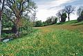
The Hachinger Tal with the wet meadows on the Hachinger Bach south of Taufkirchen was designated in 2014 by the district as the Hachinger Tal landscape protection area in the area of the municipalities of Oberhaching and Taufkirchen (LSG-00600.01). As early as 1992, the biotope mapping Bayern Flachland called these wet meadows "the most important of their kind in the Munich district because of their large area". Several artificial wetland biotopes have been created near the wet meadows , including two larger ones at the orchard meadow south of the sports and leisure park, an adventure biotope north of the Marklweg and other smaller ones along the drainage ditch east of the Pöttinger Weg and also between Hachinger Bach and Tölzer Straße. A meadow orchard with bird nesting places and insect nesting aids has also been created on Marklweg. The wetlands show a varied fauna, including some moths as skipper , checkered skipper , Small Clouded Yellow , Ringlet , heath fritillary , small tortoiseshell , boloria eunomia .
After the Munich city limits, the brook then flows through another landscape conservation area, the area around the Hachinger Bach from the city limits to the infiltration point (LSG-00120.12).
Water quality and chemical water quality
As of 1999, the Hachinger Bach fulfilled the state planning targets in the entire longitudinal course with quality class II. The stream is uniformly marked by
- good oxygen supply (area of optimal saturation)
- low levels of organic pollutants and low levels of ammonium
- low phosphorus levels
- increased nitrate content (influence of groundwater).
The values for pollutants are to be assessed as low and correspond to those of the Isar, which is also moderately polluted .
The duck pond in Taufkirchen with large populations of water birds and the drainage ditch are to be assessed as heavily polluted and indicate a need for action.
literature
- Dietrich Grund, Andreas Huber (Ed.): The Hachinger Bach. Its origins - its people - its mills . Books on Demand, Norderstedt 2014, ISBN 978-3-7347-3106-8 .
- Adolf Hackenberg, Georg Mooseder (ed.): The mysterious Hachinger Bach . 3rd, exp. Edition. Festring Perlach eV, Munich 2002.
- Anonymous: Description of the Hachinger Bach. A statistical-topographical contribution to Munich's surroundings . Joseph Lindauer, Munich 1820 ( limited preview in the Google book search).
- Anonymous: Through the Hachinger Valley. Illustrated guide for hikers and summer visitors . Bavarian Oberland, Munich 1914.
Web links
- hachinger-bach.de: Photo documentation of the stream
- Hydrogeological scheme of the Hachinger Bach on hachinger-bach.de
- Hachinger Tal Landscape Park - Renaturation of the Hachinger Bach in Unterhaching (PDF; 315 kB)
- The Hachinger Bach - renaturation in Perlach
- Groundwater model Eastern Munich gravel plain (PDF; 10.2 MB)
- Where does the water of the Hachinger Bach run to? (www.nordostkultur-muenchen.de) (PDF; 9.3 MB)

Park trees at the Hachinger Bach autobahn pond
Hachinger Bach south of Taufkirchen. Here the stream reaches up to five meters wide and half a meter deep.

Hachinger Bach near Potzham in winter

Vegetation on the Hachinger Bach between the bridge at Mühlweg and the pedestrian walkway at the level of Bergstrasse

Construction of an artificial breeding wall for the kingfisher at the Hachinger Bach, near Potzham
Sharp buttercups and meadow sorrel on the slope of the Entenbach near the Hachinger Bach Potzham

Broken pasture on the wet meadow Taufkirchen. Liked 2013

"Arena" at the Hachinger Bach near the home house Wolfschneiderhof Taufkirchen

Renatured section of the Hachinger Bach north of the bridge "Am Heimgarten", Taufkirchen

Hachinger Bach in Unterhaching

Hachinger Bach on Pfanzeltplatz in Perlach

Hachinger Bach in the Ostpark


Individual evidence
- ↑ a b living space district of Munich. Revised and expanded 2nd edition. Published by the district of Munich. 1991, p. 294.
- ↑ Hermann Jerz : The Wolfratshausener pool. Its glacial structure and deepening. In: Ice Age and the Present. 29, pp. 63-69 (1979).
- ↑ a b c d e f g Adolf Hackenberg, Georg Mooseder (ed.): The mysterious Hachinger Bach . Festring Perlach eV 3rd, extended edition. 2002.
- ↑ a b c d Ralph Annau: The surface and underground drainage conditions in the Hachinger Valley south of Munich. Institute for General and Applied Geology at LMU Munich. Diploma thesis 1997.
- ↑ Dr. - Ing. Chr. Kölling, ISAR CONSULT GmbH Dipl. - Geol. Chr. Tomsu, ISAR CONSULT GmbH Groundwater model of the eastern Munich gravel plain; in: Environmental Report of the City of Munich, pp. 59–66 (unabridged version); Munich, June 2003 [1]
- ↑ Parabraunerde from low terrace gravel (Isar area)
- ↑ E. Rutte: Bavaria's Earth History - The geological guide through Bavaria. Ehrenwirth Verlag, Munich 1992, ISBN 3-431-02348-7 .
- ↑ a b c d Dietrich Grund, Andreas Huber: The Hachinger Bach. Its origins - its people - its mills . BoD, Norderstedt 2014.
- ↑ Hachinger Bach: Hydrogeology
- ↑ a b Erwin Schirm: The hydrogeological conditions of the Munich gravel plain east of the Isar. Contribution to the UNESCO hydrological decade. Bavarian State Office for Hydrology. Munich 1968. (Diss.)
- ↑ Christl Knauer-Nothaft: Berg am Laim: from Hofmark to Munich's district. Munich 1987, p. 17.
- ↑ Hachinger Tal was a cultural focal point. In: Münchner Merkur. May 12, 2012.
- ↑ Short guide to the local history museum Taufkirchen. ( Memento of the original from December 9, 2015 in the Internet Archive ) Info: The archive link was automatically inserted and not yet checked. Please check the original and archive link according to the instructions and then remove this notice. (pdf)
- ↑ Karfunkelstein and silk - new treasures from Bavaria's early days. A joint project of the Bavarian State Office for Monument Preservation and the Archaeological State Collection Munich. Monument Preservation Information, 146 (2010)
- ↑ Important early medieval grave finds in Munich-Perlach
- ^ Dietrich reason. Small chronicle of Taufkirchen. BoD Norderstedt. 2016. ISBN 978-3-7431-1725-9 . P. 38
- ^ Karl Hobmair: Hachinger Heimatbuch, self-published by Kath. Pfarramt Oberhaching. 1979. Reproduced from: Dietrich Grund. Small chronicle of Taufkirchen. BoD Norderstedt. 2016. ISBN 978-3-7431-1725-9 . P. 38
- ↑ Anonymous: Description of the Hachinger Bach. A statistical-topographical contribution to Munich's surroundings . Joseph Lindauer, Munich 1820 ( limited preview in the Google book search).
- ↑ Flood protection on the Hachinger Bach. Everyone in the boat again. In: sueddeutsche.de , February 16, 2015.
- ↑ Unterhaching Protection against floods of the century (Münchner Wochenanzeiger November 28, 2013)
- ↑ Frost curiosity: brooks freeze from the bottom. Press release State Office for Environment and Water Management Munich from January 13, 2009.
- ↑ Effective flood protection. Breu & Schneider GmbH Verlag und Werbeagentur (HALLO), October 19, 2016, p. 3 , accessed on October 25, 2016 .
- ↑ a b Wolfgang Neber, Michael Thiele: The Hachinger Bach. Development concept for a south-facing green corridor in the Munich gravel plain. Shown from the perspective of landscape architecture. Diploma thesis landscape maintenance, FH Weihenstephan 1993.
- ↑ a b c d Blasy & Mader. Consulting engineers. Eching am Ammersee (1999). Water management plan Hachinger Bach. Oberhaching, Taufkirchen, Unterhaching, Neubiberg, City of Munich. Edition state capital Munich.
- ↑ Mills on the Hachinger Bach
- ↑ Karl Hobmair: Hachinger Heimatbuch 1979. S. 557 ff.
- ↑ Allgemeine Anzeiger and national newspaper of the Germans . Gotha 1820, Sp. 1916.
- ↑ The first mills on the Hachinger Bach go back to Roman times. See: Rupert Gebhard (Ed.): Festschrift for Hermann Dannheimer for his 80th birthday. Augsburg 2010, p. 189.
- ↑ Hachinger Bach is renatured. Taufkirchen · project continued. In: Münchner Wochenanzeiger. August 27, 2008.
- ^ Berg am Laim · Renaturation of Hachinger Bach: City approves funding. In: Münchner Wochenanzeiger. October 14, 2014.
- ↑ "Hachinger Bach should reappear", Münchner Merkur April 29, 2017
- ↑ Oberhaching. Updating and supplementing the land use plan with an integrated landscape plan. Explanatory report
- ↑ Fischerverein Hachinger Grund ( Memento of the original from January 31, 2016 in the Internet Archive ) Info: The archive link was inserted automatically and has not yet been checked. Please check the original and archive link according to the instructions and then remove this notice.
- ↑ BayernNetz Natur-Projekt "Feuchtwiesen am Hachinger Bach" (Landratsamt München, Infoblatt Sept. 2011) ( Memento of the original from April 5, 2013 in the Internet Archive ) Info: The archive link was inserted automatically and not yet checked. Please check the original and archive link according to the instructions and then remove this notice.
- ↑ Biotope mapping Bavaria lowlands. Biotope description for property number X7935-3G from June 1, 1992, District Office Munich
- ↑ protectedplanet.net