Ostpark (Munich)
The East Park is a public park in Munich district Neuperlach , which was planned since the 1960s and opens 1,973th
history
As early as 1918, the establishment of a park for the eastern parts of the city was discussed in the Munich magistrate. However, the ideas only became realistic when in 1962 the decision was made to build a large “relief town” Neuperlach for 80,000 inhabitants. In the course of the planning, the landscape architecture professor Ludwig Roemer planned a park into which the leisure facilities planned for the new settlement were to be integrated. As the plans for the large estate became more specific, the park plans were also further elaborated and the city gardening authority decided to lay out the park step by step.
In 1962 the construction of the Ostpark was formally decided. In 1965 Roemer drew up a preliminary design for the park. On November 12, 1969, the decision was made to build the first phase in the east of the 15.75 hectare site. In 1973 the decisive work for the first construction phase was carried out. On June 18, 1975, the city council decided on the second construction phase, before the first construction phase was opened to the public on July 22, 1975. On June 26, 1979, the second construction phase followed in the west with the lake, a restaurant and sports facilities. The entire area of the park of around 56 hectares was officially opened on May 27, 1982. From July 18-27, 2003, a large festival was held to mark the park's 30th anniversary.
Characterization of the park
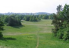
With the Ostpark, a landscape park with sunbathing lawns, tree-lined hills and bodies of water as a popular recreational area in the south-east of Munich was created from a once flat arable area.
The mounds were heaped up from rubble and gravel from the construction of Neuperlach and the subway . In addition to a branching network of paths, garden architect Josef Wurzer created a 3.5 hectare lake with a large central island, which is fed by groundwater wells , in the west of the park . The originally planned feeding of the lake by the nearby Hachinger Bach was not carried out for reasons of water protection. The approx. 700 m long circumference of the lake island is a popular natural ice skating track in winter.
The park offers ball game and table tennis courts, ice stock rinks and a small open-air stage (the Theatron). The Michaeligarten beer garden is located on the north shore of the lake (3,000 seats, restaurant with restaurant, Haberl gastronomy). An ice rink with a 400-meter track is embedded in the park; the Michaelibad outdoor pool, which has existed since 1955, is directly adjacent to the park; the indoor pool of the Michaelibad was added in 1973.
Just south of the park is the Youth Cultural Center of the Festspielhaus .
In the mid-1970s there was also a small summer ski jump in the Ostpark with a K point of 15 m.
photos
See also
Web links
- State capital Munich: Ostpark
- State capital Munich: Green oases: The Ostpark
Individual evidence
- ↑ Amrei Mosbauer, Christoph Valentien: The communal green development in Munich . In: Oberbayerisches Archiv, Volume 115 (1991), pp. 205-282, 239 f.
- ↑ Ski jumping hill archive: Ostpark - Munich
Coordinates: 48 ° 6 ′ 49 ″ N , 11 ° 38 ′ 17 ″ E


