
Deininger pond
|
Deininger Weiher Gleißental pond |
||
|---|---|---|

|
||
| Deininger pond | ||
| Geographical location | Bavaria | |
| Tributaries | Inlet ditch | |
| Drain | Gleißenbach | |
| Places on the shore | Gleißentalweiher | |
| Location close to the shore | Großdingharting , Munich | |
| Data | ||
| Coordinates | 47 ° 57 '58 " N , 11 ° 31' 25" E | |
|
||
| Altitude above sea level | 616 m | |
| surface | 2.7 ha | |
| length | 260 m | |
| width | 100 m | |
| volume | 40,500 m³ | |
| Maximum depth | 1.80 m | |
| Catchment area | 2.3 km² | |

The Deininger Weiher , also Gleißental-Weiher , is a moor lake in Großdingharting - Straßlach and belongs to the community of Straßlach-Dingharting .
geography
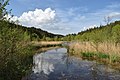
The lake is about 20 km south of Munich. It is the center and namesake of a recreation area in a landscape shaped by the Ice Age. The hamlet of Gleißentalweiher with an inn with overnight accommodation is located directly on its north side . With a depth of only 1.80 m, the water heats up quickly and is a correspondingly popular destination for bathers. The lake is almost 100 meters wide and 260 meters long, has a volume of 40,500 cubic meters and a catchment area of 2.3 square kilometers. The depth of view is rather low, as it is a typical moor lake with a dark brown color. In the bank area there are mainly beeches and oaks, otherwise there is a spruce forest in the moraine wall . The silting process can be clearly observed in the southern area. There are bathing opportunities in several places.
Part of the lake is a nature reserve ; Slow worms , grass snakes , vipers and turtles live in the habitat.
Emergence
The pond was created in the Würme Ice Age . It is a dead lake that emerged from the Egling -Deininger glacier tongue . This glacier tongue was in turn part of the former Wolfratshausen glacial basin . The outflow of the lake on the northern side into the Gleißenbach also represents the location of the former glacier gate. Depending on the season, the water seeps away after a few meters in the scree bed of the former glacial drainage channel of the Gleißental , which extends to the Oberhaching district of Deisenhofen .
A small brook marked with an inlet ditch , which has already taken in the Weiherbachl coming from Deining , is today's tributary of the pond.
Protected areas
The lake is located in the southern Gleißental landscape protection area in the area of the communities Dingharting and Oberbiberg (LSG-00286.01) and in the FFH area Moore between Dietramszell and Deining (8135-371.01).
photos

Stepping stone to the bathing area

Public house

Deininger pond

In winter with a layer of ice
At the southern end


See also
Web links
Individual evidence
- ↑ Waldhaus Deininger Weiher, Deininger Weiher 4 [1]
- ↑ Don't worry about the queue , merkur.de, April 26, 2013, accessed on February 24, 2017
- ↑ World Database on Protected Areas - Southern Gleißental in the area of the communities Dingharting and Oberbiberg (English)
- ↑ World Database on Protected Areas - Moore between Dietramszell and Deining (English)
- ↑ 8135-371 Moore between Dietramszell and Deining. (FFH area) Profiles of the Natura 2000 areas. Published by the Federal Agency for Nature Conservation . Retrieved November 24, 2017.