Gleißental
The Gleißental is a slightly more than eight kilometers long and about 25 meters deep cut in the district of Munich . The dry valley extends from the Deininger Weiher in the south to the Oberhachingen district of Deisenhofen in the north. There it goes over into the valley of the Hachinger Bach . The Deininger Weiher, which is also referred to as the Gleißentalweiher , has the Gleißenbach as its drain , which first enters the Gleißental, but seeps away after a few hundred meters.
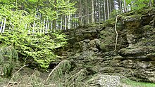
On both sides of the valley are several Viereckschanzen the Celts . In the railing channel there are geological features such as the Nagelfluh and outcrops up to the Tertiary . 264 hectares in the southern Gleißental are designated as a landscape protection area.
Emergence
The Gleißental was formed towards the end of the Würm Glaciation , i.e. around 20,000 to 14,000 years ago as a result of the runoff of the meltwater from the Isar-Loisach glacier . The valley is a glacial drainage channel of what was then Eglinger Glacier Finger , which in turn came from the Wolfratshausen glacial basin. The current discharge of the Deininger Weiher was the former glacier gate of the Wolfratshausen glacial basin and today marks the beginning of the valley.
Geotope
The Gleißental is designated as a geotope (184R002) by the Bavarian State Office for the Environment .
literature
- Rolf KF Meyer, Hermann Schmidt-Kaler: Walks into the history of the earth (8), On the trail of the Ice Age south of Munich - eastern part , 1997. ISBN 3-931516-09-1
- Iris Hilberth: A quarry from mystical times , article in the Starnberg local edition of the Süddeutsche Zeitung. Online version from August 13, 2017.
Web links
Individual evidence
- ↑ Oberhaching.de ( Memento of the original from September 30, 2011 in the Internet Archive ) Info: The archive link was automatically inserted and not yet checked. Please check the original and archive link according to the instructions and then remove this notice.
- ↑ Geotope: Gleißental SW von Geisenhofen (must read: SW von Deisenhofen) (accessed on November 7, 2015)
Coordinates: 47 ° 59 ′ 33 ″ N , 11 ° 33 ′ 24 ″ E


