
Hachinger Tal landscape park
Hachinger Tal landscape park |
|
|---|---|
|
|
|

|
|
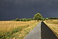
| View of the former runway | |
| Basic data | |
| place | Neubiberg |
| Created | 2001 |
| use | |
| User groups | Pedestrians , cyclists , leisure |
| Technical specifications | |
| Parking area | 1,260,000 m² (around 126 hectares) |
The Hachinger Tal landscape park is a 126 hectare landscape park in the administrative area of Neubiberg , Ottobrunn and Unterhaching in the south of Munich . It was built on the site of the former Neubiberg air base (without a building).
In 1997 the municipality of Unterhaching near Munich bought a large part of the abandoned airfield and began to gradually redesign it from 2001 onwards. The design comes from the landscape architecture office Atelier Loidl from Berlin .
Recreational use
The landscape park is divided into different zones: While the southern / southeastern part is largely reserved for nature, sports and adventure areas are west of the motorway bridge and in the northeast, in the part belonging to Neubiberg .
The former runway , which forms the central axis of the park, today a. Inline skaters and kite surfers . Dogs are allowed to run free on the so-called dog mile on the northern edge of the park, but must be kept on a leash on the remaining area.
Other leisure facilities include a fun park, beach volleyball and soccer fields as well as a water playground at the Hachinger Bach.
nature
The area includes a remaining area of the former 'Perlacher Haid', an extensive grass heather that has been created through many years of grazing. The meadows are becoming species-rich, rough meadows, and in some places also rough lawns . Species that are on the Red List of Threatened Animal Species occur on these areas, which are temporarily not allowed to be entered . B. Skylark , Quail , Idas blue and sky blue blue .
In the peripheral areas, bushes were planted, which serve as breeding grounds for red- backed red-backed shrimp , yellow mockers and blackcocks . In addition, the sand lizard occurs.
Several spawning waters for amphibians have been created by the municipality of Unterhaching and the city of Munich . You serve v. a. the protection of endangered in Bavaria extinction toad . There are also other species such as the tree frog and mountain newt .
Orchards have been created to the west of the motorway . The Hachinger Bach , which flows through the area to the west, has been renatured and an alluvial forest has been planted. Bridges on the stream draw v. a. those looking for relaxation on warm days.
It is remarkable that the citizens of Unterhaching are included in the design and maintenance of the landscape park. So there are u. a. a working group "Obstwiese", whose members take over the planting and maintenance of the orchard on a voluntary basis. The working group “Awareness Raising Landscape Park” takes care of the information of the visitors, in particular information about flora and fauna and the protection areas for the threatened species.
The Hachinger Tal landscape park is part of the Munich green belt .
Former bunkers
There are several filled-in bunkers on the site .
Illustrations

Landscape Park Hachinger Tal - Hachinger Bach

Hachinger Bach

Protected area for ground-nesters

Dog mile

Landscape Park Hachinger Tal - former bunker area

Landscape Park Hachinger Tal - Hornbeam

Landscape Park Hachinger Tal - orchard meadow
Hachinger Tal landscape park

Hachinger Tal landscape park - meadow breeding reserve

Overview map


Web links
Individual evidence
- ^ Hachinger Tal leaflet ( page no longer available , search in web archives ), bnn.pan-gmbh.de, accessed on April 6, 2016, .pdf
- ↑ Local Agenda 21 , agenda21-unterhaching.de, accessed on April 6, 2016
- ↑ Michael Morosow: Children discover the entrance to an underground bunker. In: sueddeutsche.de . April 23, 2017. Retrieved October 13, 2018 .
Coordinates: 48 ° 4 ′ 16 ″ N , 11 ° 38 ′ 13 ″ E