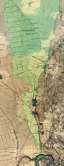
Grub-Harthausener dry valley
After the Würm Ice Age 20,000 to 14,000 years ago, parts of the Isar-Loisach Glacier , the Inn Glacier and the smaller glaciers from the valleys of the Tegernsee , Schliersee and Leitzach flowed through the Grub-Harthausener dry valley .
Emergence
Three rivers met at the so-called Mangfallknie in the municipality of Valley : Coming from the west the Teufelsgraben, fed by the Isar Glacier, and from the south the Ur-Mangfall with the meltwater of the Mangfall , Schlierach and Leitzach. From the east, opposite to the current direction of flow, the meltwater flow of the Inn Glacier flowed in.
From the Mangfallknie the drainage channel of the Ur-Mangfall led through today's Grub-Harthausen dry valley further north. According to the Department of Geosciences and Environmental Sciences at the Ludwig Maximilians University in Munich, " this phenomenon can only be seen in this clarity here in the Bavarian foothills of the Alps ".
Further development
When the Inn glacier melted, the current changed direction and headed east towards the Inn . As a result, the Grub-Harthausen meltwater channel dried up. The valley floor of the Teufelsgraben is around 40 meters lower than the bottom of the dry valley today.
Since the retreat of the Isar glacier, the remaining water in the bed of the Isar has been flowing north and the Teufelsgraben also fell dry. So today the bottom of the Mangfall knee is 55 meters lower than the trench to the north.
location
Starting from the Mangfallknie, the dry valley leads about 16 km north to the Grasbrunn district of Harthausen .
literature
- Walter Grottenthaler: On the Worm Period Deglaziationsgeschichte in the Mangfall area , Geologica Bavarica Vol. 102, pp. 393-407, Munich, 1997
Individual evidence
- ↑ Introduction
- ^ Department for Geo and Environmental Sciences at LMU
- ↑ The Tölzer Lobus as the subject of a geodidactic excursion, p. 59 (PDF; 16.8 MB)
- ↑ p. 61 (PDF; 16.8 MB)
Web links
- Statement by the Department of Geosciences and Environmental Sciences at the Ludwig Maximilians University in Munich
- Grub-Harthausener dry valley
Coordinates: 47 ° 55 ′ 30 ″ N , 11 ° 47 ′ 11 ″ E
