
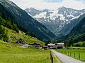
Stillup Valley


The Stilluptal , spelling also Stillupptal , also called Stillupgrund , Stilluppgrund or Stilluppe , is a valley in the Zillertal Alps ( Tyrol , Austria ) that begins near Mayrhofen and extends to the main ridge of the Zillertal Alps. From the main ridge, the valley runs largely in a north-westerly direction. Shortly before it flows into the Mayrhofen basin, the valley narrows sharply and bends in a north-easterly direction.
The Stilluptal is enclosed by the Ahornkamm with the Ahornspitze (2973 m), the Zillertaler Hauptkamm with Wollbachspitze (3209 m) and Großem Löffler (3379 m) and the Floitenkamm with Gigalitz (3001 m), Floitenturm (2805 m) and Dristner (2767 m) ). Adjacent valleys of the Stilluptal are the Zillergrund in the north and northeast , the Ahrntal in South Tyrol in the southeast, the Floite in the southwest and the Zemmtal in the west .
The Stilluptal is drained by the Stilluppbach . In the narrow section of the valley before Mayrhofen, the Stilluppbach falls through the Stilluppklamm.
tourism
In the upper Stilluptal is the Kasseler Hütte (2178 m), a refuge of the German Alpine Club . It is a station on the Berliner Höhenweg . This comes over the Lapenscharte (2701 m) into the Stilluptal and circles its upper part at an altitude of 2100 to 2300 m to the Kasseler Hütte. From there the path leads along the Ahornkamm to the Karl-von-Edel-Hütte below the Ahornspitze.
A hiking trail with the AV number 515 leads through the entire Stilluptal valley. This ultimately leads to the Berliner Höhenweg near the Kasseler Hütte. Shortly after the Gasthof Grüne-Wand-Hütte , hiking trail 518 branches off, which also leads to the Berliner Höhenweg, but below the Lapenscharte. However, the lower part of this path is currently closed (as of 2013) due to a rock fall. The AV hiking trail 514 leads from the valley floor near the dam to the Filzenalm near the Ahornbahn mountain station .
In addition to the Green Wall Hut , the Stillupphaus and the waterfall inn are further places to stop off in the Stilluptal. The former Lacknerbrunn tavern is only an apartment building, so there is no longer any place to stop for a break .
Stilluphaus with the head of the valley

Green wall hut

Kasseler hut with big spoonbill

Karl von Edel Hut


Infrastructure

The Stillup Valley is dominated by the Stillup reservoir , a reservoir that was created in 1969 to generate energy and at the same time serves to protect against floods in the Zillertal . With the storage facility, the road infrastructure up to the storage facility was also expanded, which previously only looked like a forest road. The road is now operated as a toll road . Private buses also continue to the Green Wall Hut at the end of the valley, a starting point for hikers and mountaineers.
Web links
supporting documents
- ↑ Spelling according to an official announcement of the federal state of Tyrol ( page no longer available , search in web archives ) Info: The link was automatically marked as defective. Please check the link according to the instructions and then remove this notice.
- ↑ G. Morteani: Structure and metamorphosis of the series between Stillupptal and Schlegeistal, Vienna 1971 (PDF; 1.1 MB)
- ↑ Bote für Tirol (Official Gazette of the Authorities, Offices and Courts of Tyrol), December 22, 1999, p. 668f (PDF; 94 kB)
- ^ Austrian Alpine Club: Approaches to the Karl-von-Edel-Hütte
- ↑ a b c d e f g Alpine Club Card 35/2: Zillertal Alps - Central. 7th edition 2008.
- ↑ Map 1: 10,000 of the Austrian Federal Office for Metrology and Surveying , slightly different delivery (2177 m) at the hut
- ^ P Ganahl: Retention of a hundred-year event by the granaries in the Zillertal. Graz 1988. (PDF; 1.3 MB)
- ↑ Private bus service in Stilluptal
Coordinates: 47 ° 7 ' N , 11 ° 52' E