
Mountain learning
| coat of arms | Germany map | |
|---|---|---|

|
Coordinates: 48 ° 23 ' N , 11 ° 56' E |
|
| Basic data | ||
| State : | Bavaria | |
| Administrative region : | Upper Bavaria | |
| County : | Erding | |
| Management Community : | Wartenberg | |
| Height : | 440 m above sea level NHN | |
| Area : | 19.88 km 2 | |
| Residents: | 2982 (Dec. 31, 2019) | |
| Population density : | 150 inhabitants per km 2 | |
| Postal code : | 85459 | |
| Area code : | 08762 | |
| License plate : | ED | |
| Community key : | 09 1 77 112 | |
| LOCODE : | DE B9T | |
| Association administration address: | Marktplatz 8 85456 Wartenberg |
|
| Website : | ||
| First Mayor : | Anton Scherer (Berglerner Citizen List) | |
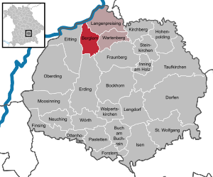
| Location of the municipality of Berglern in the district of Erding | ||
  |
||

Berglern is a municipality in the Upper Bavarian district of Erding and a member of the Wartenberg administrative community .
geography
location
Berglern is located in the Munich region in the middle of the Erdinger Moos , about halfway between the cities of Moosburg an der Isar (11 km) and Erding (9 km). For Munich Airport is 12 km away.
Community structure
In addition to Berglern, the community also consists of the districts Glaslern , Mitterlern and Niederlern .
Neighboring communities
The neighboring communities (clockwise) are: Langenpreising , Wartenberg (Upper Bavaria) , Fraunberg , Erding and Eitting - all in the Erding district - and Langenbach (Upper Bavaria) - in the Freising district.
Waters
The Middle Isar Canal flows between the districts of Mitterlern and Berglern .
history
The urn grave field , which was only found east of the parish church of St. Peter and Paul in 1952, indicates an early settlement. The first documentary mention comes with an exchange of land between Bishop Atto von Freising (783 - 793) and a certain Hungis "in loco qui dicitur Hiera". Before 1800, Berglern belonged to the Landshut Rent Office and the Erding District Court of the Electorate of Bavaria. In 1818, with the municipal edict, today's political municipality was created. The Altenerding – Pfrombach railway line built for its construction ran along the Middle Isar Canal until 1967 .
Residents
According to the Bavarian State Office for Statistics , the population figures developed as follows on December 31 of each year:
| was standing | Residents |
|---|---|
| 1960 | 1036 |
| 1970 | 1014 |
| 1980 | 1127 |
| 1990 | 1309 |
| 1995 | 1660 |
| 2000 | 2198 |
| was standing | Residents |
|---|---|
| 2005 | 2406 |
| 2006 | 2472 |
| 2007 | 2515 |
| 2008 | 2539 |
| 2009 | 2564 |
| 2010 | 2568 |
| was standing | Residents |
|---|---|
| 2011 | 2562 |
| 2012 | 2626 |
| 2013 | 2672 |
| 2014 | 2717 |
| 2015 | 2711 |
| 2016 | 2815 |
Since 1972, the year of the municipal reform, the population has increased by 1774 people until 2016. This corresponds to a growth of 170.41 percent. In the last ten (five) years the population increased by 11.93 (7.2) percent.
Between 1988 and 2018, the municipality grew from 1,227 to 2,951 by 1,724 inhabitants or 140.5% - the highest percentage increase in the district and fourth-highest value in Bavaria in the period mentioned.
politics
Municipal council
The municipal council consists of 14 members:
Then there is the mayor.
mayor
The honorary first mayor is Anton Scherer (Berglerner Bürgerliste). He has been in office since May 1, 2020. In the 2020 mayoral election , he was elected in the first ballot with 72.8 percent of the vote. His predecessor was Simon Oberhofer (Free Voters).
badges and flags
The coat of arms of the municipality was laid down on September 4, 1962 with the following blazon : “Divided by red and silver; above a silver heraldic rose, below a green three-mountain . ”In addition to the coat of arms, the municipality wields a flag with the colors red-white-green with the city coat of arms.
Community finances
The municipal tax revenue in 1999 was the equivalent of € 742,000, of which € 196,000 (net) was trade tax income.
Culture and sights
Natural monuments
The Viehlaßmoos nature reserve is to the northwest of Niederlern ; the eastern part of the nature reserve is in the municipality, the western part belongs to the municipality of Eitting .
Architectural monuments
- Catholic parish church St. Petrus and Paulus in Berglern: Stately hall, choir and tower in the core late Gothic. New nave 1734/35, choir and tower elevation by Johann Baptist Lethner 1778
- Catholic branch church St. Andreas in Niederlern: Built in 1678 by Hans Kogler , above the medieval core
Economy and Infrastructure

Industry, trade and commerce
In 1998, according to official statistics, there were 109 in the manufacturing industry and in the trade and transport sector no employees subject to social security contributions at the place of work. In other economic sectors, 13 people were employed at the place of work subject to social security contributions. There were a total of 787 employees at the place of residence subject to social security contributions. There were four companies in the manufacturing sector and five in the construction sector.
Agriculture and Forestry
The agriculturally used area was 1720 ha in 1999, of which 1538 ha were arable land. While there were 57 farms in 1999, their number had fallen to 39 by 2010.
| Farm size in ha | Number of establishments | |
|---|---|---|
| 1999 | 2010 | |
| under 5 | 8th | 2 |
| 5 to under 10 | 4th | 3 |
| 10 to under 20 | 18th | 8th |
| 20 to under 50 | 15th | 11 |
| 50 or more | 12 | 15th |
| total | 57 | 39 |
traffic
Berglern is located exactly in a flight path to Munich Airport. Berglern would be affected by the planned third runway; in a westerly wind - coming from the east - 437 landing approaches would be made over the center of Berglern every day.
education
In 2015 the following institutions existed:
- 2 day-care centers with 258 places and 153 children (compared to 2014, an additional 84 places have been created)
- Elementary schools: one with six teachers and 103 students
literature
- Günther Flohrschütz, Matthias Johannes Bauer (ed.): Learn to the 13th century. Rule structures and rulers in Berglern and the surrounding area . Herbert Utz Verlag, Munich 2006, ISBN 3-8316-0653-6
Web links
Individual evidence
- ↑ "Data 2" sheet, Statistical Report A1200C 202041 Population of the municipalities, districts and administrative districts 1st quarter 2020 (population based on the 2011 census) ( help ).
- ↑ a b Mayor / Lord Mayor in municipalities belonging to the district (as of May 1st, 2020). (xlsx) Bavarian State Office for Statistics, accessed on June 20, 2020 .
- ↑ Berglern municipality in the local database of the Bavarian State Library Online . Bavarian State Library, accessed on December 29, 2017.
- ↑ Bavarian State Office for Statistics: 12111-101z Census and population update: municipality, population (census and current), reference dates . Online at www.statistikdaten.bayern.de. Retrieved August 18, 2016.
- ^ Election of the Berglern municipality council
- ^ Entry on the coat of arms of Berglern in the database of the House of Bavarian History
- ↑ http://www.ed-wappen.de/berglern.html
- ↑ Bavarian State Office for Statistics and Data Processing: Statistics communal 2015 - Municipality of Berglern 09 177 112 - A selection of important statistical data . PDF, online at www.statistik.bayern.de, accessed on November 5, 2016.

Mountain learning | Bockhorn | Buch am Buchrain | Dorfen | Eitting | Erding | Finsing | Forstern | Fraunberg | Hohenpolding | Inning on wood | Isen | Kirchberg | Long price | Lengdorf | Moosinning | Neuching | Oberding | Ottenhofen | Patties | Saint Wolfgang | Stone churches | Taufkirchen (Vils) | Walpert Churches | Wartenberg | Wörth