
Hohenpolding
| coat of arms | Germany map | |
|---|---|---|

|
Coordinates: 48 ° 23 ' N , 12 ° 8' E |
|
| Basic data | ||
| State : | Bavaria | |
| Administrative region : | Upper Bavaria | |
| County : | Erding | |
| Management Community : | Stone churches | |
| Height : | 488 m above sea level NHN | |
| Area : | 27.42 km 2 | |
| Residents: | 1587 (Dec. 31, 2019) | |
| Population density : | 58 inhabitants per km 2 | |
| Postal code : | 84432 | |
| Area code : | 08084 | |
| License plate : | ED | |
| Community key : | 09 1 77 121 | |
| Community structure: | 57 parts of the community | |
| Association administration address: | Am Kirchberg 2 84439 Steinkirchen |
|
| Website : | ||
| Mayor : | Alfons Beilhack | |
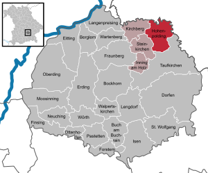
| Location of the community Hohenpolding in the district of Erding | ||
  |
||

Hohenpolding is a municipality in the northeastern district of Erding ( Upper Bavaria administrative district ). The place of the same name is both the capital and the seat of the municipal administration.
geography
The place is in the forest and hilly Erdinger Holzland between Landshut (18 km) and Dorfen (14 km) and 23 km northeast of the district town of Erding and 25 km west of Vilsbiburg . For Munich Airport is about 35 km away. The northern municipality border forms the border between Upper Bavaria and Lower Bavaria .
Community structure
Hohenpolding is divided into 57 officially named municipal parts.
| Parish village | Hohenpolding |
|---|---|
| Church Village | Sulding |
| Villages | Dickarting • Erdmannsdorf • Großstockach • Harting • Loiting • Penning • Starzell |
| hamlet | Buchöd • Diemating • Helding • Klesham • Krumbach • Ramperting • Reinting • Reitgarten • Sinzing • Voglstädt • Wimm |
| Hamlet with a church | Amelgering |
| Wastelands | Berghof • Brandstätt • Bürg • Eben Fuchsöd • Großaign • Gurnhub • Harland • Hilg • Hof • Hofstätt • Holzmann • Holzner • Hut • Karbaum • Kleinaign • Kleinstadl • Maierhof • Marxgrub • Penk • Pfauhub • Pilstl • Quick • Rechlfing • Reit • Resenöd • Schachten • Schachtner • Schwarzenberg • Steckenbühl • Teufelsöd • Reversal • Waltersberg • Wastlöd • Wimmberg • Zeil |
history
First mention
The place first appeared in a document in 998 under its Latin name alto baldingae .
20th century
As part of the municipal reorganization of Bavaria on January 1, 1972, the municipality of Sulding was incorporated into Hohenpolding.
Since 1978 Hohenpolding together with the communities Inning am Holz , Kirchberg and stone churches managing Community stone churches.
Residents
According to the Bavarian State Office for Statistics , the population figures developed as follows on December 31 of each year:
| was standing | Residents |
|---|---|
| 1946 | 720 |
| 1960 | 1130 |
| 1970 | 1117 |
| 1980 | 1125 |
| 1990 | 1127 |
| 1995 | 1167 |
| 2000 | 1249 |
| 2005 | 1452 |
| was standing | Residents |
|---|---|
| 2006 | 1463 |
| 2007 | 1497 |
| 2008 | 1483 |
| 2009 | 1482 |
| 2010 | 1476 |
| 2011 | 1433 |
| 2012 | 1427 |
| 2013 | 1414 |
| was standing | Residents |
|---|---|
| 2014 | 1469 |
| 2015 | 1510 |
| 2016 | 1562 |
Since 1972, the year of the municipal reform, the population has increased by 375 people until 2015. This corresponds to a growth of 33.04 percent.
Between 1988 and 2018 the municipality grew from 1,108 to 1,598 by 490 inhabitants or 44.2%.
politics
The community is a member of the Steinkirchen administrative community .
mayor
Alfons Beilhack has been the first mayor since May 2020.
badges and flags
coat of arms
|
|
Blazon : "Above a silver shield base, in it two green sea leaves on crossed stems, next to each other in blue a silver heraldic lily with a golden crown instead of the covenant and a silver cross, the vertical bar of which is covered by a golden crown"
The municipal coat of arms was set on February 8, 1983. |
In addition to the coat of arms, the municipality carries a flag with the colors white-green-yellow.
Eastern Alliance
The community participates in the Eastern Alliance .
Culture and sights

There are three church buildings in Hohenpolding and the associated districts:
- Parish Church of the Visitation in Hohenpolding, built in 1752 by Johann Baptist Lethner
- Filial church St. Lambertus in Amelgering, built in 1756/1757 by Johann Baptist Lethner
- Filial church of the discovery of the Holy Cross in Sulding, built in its current form in 1703
Soil monuments
Economy and Infrastructure
Agriculture and Forestry
While there were 89 farms in 1999, their number had fallen to 65 by 2010.
| Farm size in ha | Number of establishments | |
|---|---|---|
| 1999 | 2010 | |
| under 5 | 11 | - |
| 5 to under 10 | 13 | 8th |
| 10 to under 20 | 15th | 10 |
| 20 to under 50 | 36 | 28 |
| 50 or more | 14th | 19th |
| total | 89 | 65 |
traffic
In the west the federal highway 15 leads past the place.
Personalities
Sons and daughters of the church
- Korbinian Aigner (1885–1966), pastor and pomologist
- Margit Niedermaier, entrepreneur, winner of the Bavarian Constitutional Medal in Silver (awarded December 1, 2014)
Honorary citizen
- Josef Lechner, farmer
- Georg Lechner, blacksmith
- Hermann Oberwallner, Mayor
- Ferdinand Diemer, teacher
- Johann Sinseder, pastor
- Korbinian Bayerstorfer, Mayor
- Georg Rieder, farmer
- Georg Zehentner, mayor
- Johann Becher, headmaster
Web links
Individual evidence
- ↑ "Data 2" sheet, Statistical Report A1200C 202041 Population of the municipalities, districts and administrative districts 1st quarter 2020 (population based on the 2011 census) ( help ).
- ^ Community Steinkirchen in the local database of the Bavarian State Library Online . Bayerische Staatsbibliothek, accessed on February 12, 2020.
- ^ Wilhelm Volkert (ed.): Handbook of Bavarian offices, communities and courts 1799–1980 . CH Beck, Munich 1983, ISBN 3-406-09669-7 , p. 457 .
- ↑ Bavarian State Office for Statistics: 12111-101z Census and population update: municipality, population (census and current), reference dates . Online at www.statistikdaten.bayern.de. Retrieved September 30, 2016.
- ↑ Mayor. Hohenpolding municipality, accessed on August 22, 2020 .
- ^ Entry on the coat of arms of Hohenpolding in the database of the House of Bavarian History
- ↑ Bavarian State Office for Statistics and Data Processing: Statistics communal 2015 - Hohenpolding municipality 09 177 121 - A selection of important statistical data . PDF, online at www.statistik.bayern.de, accessed on January 4, 2017.

Mountain learning | Bockhorn | Buch am Buchrain | Dorfen | Eitting | Erding | Finsing | Forstern | Fraunberg | Hohenpolding | Inning on wood | Isen | Kirchberg | Long price | Lengdorf | Moosinning | Neuching | Oberding | Ottenhofen | Patties | Saint Wolfgang | Stone churches | Taufkirchen (Vils) | Walpert Churches | Wartenberg | Wörth