
Bockhorn (Upper Bavaria)
| coat of arms | Germany map | |
|---|---|---|

|
Coordinates: 48 ° 19 ' N , 11 ° 59' E |
|
| Basic data | ||
| State : | Bavaria | |
| Administrative region : | Upper Bavaria | |
| County : | Erding | |
| Height : | 460 m above sea level NHN | |
| Area : | 47.15 km 2 | |
| Residents: | 4064 (Dec. 31, 2019) | |
| Population density : | 86 inhabitants per km 2 | |
| Postal code : | 85461 | |
| Area code : | 08122 | |
| License plate : | ED | |
| Community key : | 09 1 77 113 | |
| Address of the municipal administration: |
Rathausplatz 1 85461 Bockhorn |
|
| Website : | ||
| Mayor : | Lorenz Angermaier ( FWG ) | |
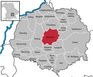
| Location of the community of Bockhorn in the district of Erding | ||
  |
||


Bockhorn ( Bavarian Bocking ) is a municipality in the center of the Upper Bavarian district of Erding .
geography
Bockhorn is located in the Munich region on the eastern edge of the Erdinger Moos, seven kilometers east of the district town of Erding , 15 km northwest of Dorfen , 24 km south of Moosburg an der Isar and about 20 km east of Munich Airport .
The Strogen divides the community geologically: the western part is flat (edge of the Munich gravel plain ), the eastern part consists of tertiary hill country ( Erdinger Holzland ).
Community structure
There are 49 officially named municipal parts (former municipalities with their districts) :
- Bockhorn with Aurlfing , Bergarn , Deimling , Emling , Haselbach , Hecken , Heiderl , Oberstrogn , Reisach , Riedersheim and Unterstrogn
- Eschlbach with Ferteln , Graß , Hammerthal , Hörgersberg , Hubberg , Hundshof , Köhl , Kreut , Kreuthäusl , Maierklopfen , Oppolding , Schwabelsöd , Tankham , Übermiething and Windham
- Grünbach
- Salmannskirchen with Breitasch , Englpolding , Flanning , Gugging , Kinzlbach , Kirchasch , Kölling , Loh , Mauggen , Neukirchen , Papferding , Thal and Wiesthof
- Obermailling , Polzing and Untermailling from the dissolved municipality of Matzbach
- Bernau , Neumauggen and Schwarzhölzl only emerged after the territorial reform of the 1970s.
There are the districts of Bockhorn, Eschlbach, Grünbach, Kirchasch, Mauggen and Salmannskirchen.
history
Until the church is planted
Due to the abundance of water and the very good creditworthiness of the soils, it can be assumed that the municipality of Bockhorn has been settled since the early Neolithic (4500 BC) at the latest. A large number of settlements have been archaeologically proven, ranging from the Münchshöfen culture through the Bronze Age to the Celtic Age. Immediately on the southern outskirts of Bockhorn are the remains of a Bronze Age settlement.
Around 500 BC The municipality was populated by the Celts ; near Papferding there are still the leveled remains of a Viereckschanze . Around 15 BC BC Rome extended its rule to the Danube on the province of Raetien and the Celts lost their independence. In the 6th century, after the end of the migration , settlements began again; Places with the ending “-ing” (Emling, Flanning, Englpolding, Oppolding, Papferding, Polzing) indicate early Bavarian settlements . In 776, Strogen and the church came into the possession of Freising . The name Grünbach first appeared in 816 when the monk Liutto donated his property in "Croninpach" to the Freising Monastery. 926 the name Bockhorn can be traced back to the spelling “Paccharun”; the name means "people by the stream". In 1053 Mauggen was first mentioned as "Muchun" in a deed of transfer of a property to Freising. In 1156 the name "Eschlbach" appeared in the traditions of the Hochstift Freising . In 1200, the construction of Grünbach Castle began in Grünbach . In 1315 Bockhorn (spelling now "Pachorn") with the branches Kirchasch, Hecken, Salmannskirchen, Grünbach and Tankham is listed as a parish. In 1801, construction of the Grünbach Castle, which still exists today, began in Grünbach .
20th and 21st centuries
In 1920 and 1942 there were great floods from the strogens. In 1972, construction of the golf course (Erding-Grünbach Golf Club) began in the Grünbach district (expanded in 1978) and the Federal Institute for Plant Genetics was established in Grünbach Castle (until 1999). In 2002 the new town hall of Bockhorn was opened.
Incorporations
On January 1, 1972, the communities of Bockhorn, Eschlbach , Grünbach and Salmannskirchen were merged to form the new community of Bockhorn. On May 1, 1978, three places in the southeast of the dissolved Matzbach community were added.
Residents
According to the Bavarian State Office for Statistics , the population figures developed as follows on December 31 of each year:
| was standing | Residents |
|---|---|
| 1960 | 2331 |
| 1970 | 2309 |
| 1980 | 2485 |
| 1990 | 2704 |
| 1995 | 2956 |
| was standing | Residents |
|---|---|
| 2000 | 3153 |
| 2005 | 3447 |
| 2010 | 3542 |
| 2015 | 3720 |
| 2016 | 3803 |
Since 1972, the year of the municipal reform, the population increased by 1,511 people until 2016. This corresponds to a growth of 65.92 percent. In the last ten (five) years the population grew by 63.15 (20.62) percent.
Between 1988 and 2018 the community grew from 2,636 to 4,005 by 1,369 inhabitants or 51.9%.
politics
mayor
Hans Schreiner (FWG) was first mayor from 2002 to the end of April 2020. In the mayoral election 2020 , in which Hans Schreiner was no longer a candidate, Lorenz Angermaier (Free Voting Community Bockhorn / Citizens List Kirchasch and the surrounding area) was elected.
coat of arms
|
|
Blazon : “In red over a silver horn with gold fittings, a silver wave bar. The wave bar symbolizes the small river Strogen near Bockhorn, the silver horn comes from the community of Grünbach , as a reference to the noble family of the power of Grünbach. " |
The flag has the colors white and red.
Community finances
The municipal tax revenue amounted to the equivalent of 1,374,000 euros in 1999, of which 206,000 euros were trade tax revenues (net).
Parish partnership
-
 Magnac-sur-Touvre , Charente department , France, since 2008
Eastern Alliance
The community participates in the Eastern Alliance .
Culture and sights
Architectural monuments


- Bockhorn, Parish Church of the Visitation , Baroque hall church from 1712 through the Erdinger city master builder Anton Kogler built tower superstructure with spindle helmet by his successor Johann Baptist Lethner built
- Kirchasch, branch church St. Martin, hall building with onion dome by Johann Baptist Lethner (around 1760), parts of the aisle from the 14th century.
- Eschlbach, parish church of St. Mary's Birth (1679), rich rococo furnishings around 1765
- Grünbach, Filialkirche St. Andreas (1669)
- Grünbach, Castle (1794–1847)
- Haselbach, branch church of St. John the Baptist (around 1200)
- Hecken, St. Margaretha branch church, built by Johann Baptist Lethner in 1754/55
- Oppolding, branch church of St. John the Baptist , built in 1764 by Johann Baptist Lethner, with charming Rococo furnishings
- Salmannskirchen, St. Oswald's branch church, built in 1751 by Johann Baptist Lethner
Soil monuments
In the municipality there are 15 burial mounds at nine sites near Untermailling, Hubberg, Eschlbach , Riedersheim and Bockhorn. The highest density of burial mounds from the period between 1600 and 1300 BC can be found here within a few kilometers. In the whole district.
Economy and Infrastructure
Industry, trade and commerce
In 1998 there were 163 in manufacturing and 25 in trade and transport at the place of work. In other economic areas, 100 people were employed at the place of work subject to social security contributions. There were 1020 employees subject to social security contributions at the place of residence. There was one in manufacturing and twelve in construction.
Agriculture and Forestry
In 1998 there were six employees in agriculture and forestry who were subject to social security contributions at the place of work. The agriculturally used area in 1998 was 3665 ha, of which 2915 ha were arable land.
While there were still 140 farms in 1999, their number had fallen to 109 by 2010.
| Farm size in ha | Number of establishments | |
|---|---|---|
| 1999 | 2010 | |
| under 5 | 17th | 7th |
| 5 to under 10 | 16 | 9 |
| 10 to under 20 | 28 | 25th |
| 20 to under 50 | 62 | 46 |
| 50 or more | 17th | 22nd |
| total | 140 | 109 |
traffic
The federal road 388 and the state road 2084 run through the municipality . There is a public transport connection through the MVV bus lines . The Munich – Mühldorf railway line touches the community in the south, the next stop is in Walpertskirchen .
education
- Kindergartens for 112 children (1999)
- Elementary school for 157 pupils (2008)
Web links
- Bockhorn community
- Bockhorn (Upper Bavaria): Official statistics of the LfStat
- Pictures of the sights
Individual evidence
- ↑ "Data 2" sheet, Statistical Report A1200C 202041 Population of the municipalities, districts and administrative districts 1st quarter 2020 (population based on the 2011 census) ( help ).
- ↑ Election of the first mayor - municipal elections 2020 in the municipality of Bockhorn - overall result. Retrieved May 1, 2020 .
- ^ Bockhorn community in the local database of the Bavarian State Library Online . Bavarian State Library, accessed on December 29, 2017.
- ↑ Bavarian State Statistical Office (ed.): Official city directory for Bavaria, territorial status on October 1, 1964 with statistical information from the 1961 census . Issue 260 of the articles on Bavaria's statistics. Munich 1964, DNB 453660959 , Section II, Sp. 70-71 ( digitized version ).
- ↑ Monument view in the Bavaria Atlas
- ^ Wilhelm Volkert (ed.): Handbook of Bavarian offices, communities and courts 1799–1980 . CH Beck, Munich 1983, ISBN 3-406-09669-7 , p. 457 .
- ^ Federal Statistical Office (ed.): Historical municipality directory for the Federal Republic of Germany. Name, border and key number changes in municipalities, counties and administrative districts from May 27, 1970 to December 31, 1982 . W. Kohlhammer, Stuttgart / Mainz 1983, ISBN 3-17-003263-1 , p. 573 .
- ↑ Bavarian State Office for Statistics: 12111-101z Census and population update: municipality, population (census and current), reference dates . Online at www.statistikdaten.bayern.de. Retrieved August 19, 2016
- ^ Entry on the coat of arms of Bockhorn (Upper Bavaria) in the database of the House of Bavarian History
- ↑ archaeologischer-Verein-erding: AVEinfo: Interesting facts from archeology and ground monument preservation in and around Erding, issue 7, p. 20
- ↑ Bavarian State Office for Statistics and Data Processing: Statistics communal 2015 - Bockhorn municipality 09 177 113 - A selection of important statistical data . PDF, online at www.statistik.bayern.de, accessed on November 6, 2016.

Mountain learning | Bockhorn | Buch am Buchrain | Dorfen | Eitting | Erding | Finsing | Forstern | Fraunberg | Hohenpolding | Inning on wood | Isen | Kirchberg | Long price | Lengdorf | Moosinning | Neuching | Oberding | Ottenhofen | Patties | Saint Wolfgang | Stone churches | Taufkirchen (Vils) | Walpert Churches | Wartenberg | Wörth
Aurlfing | Mountain yarn | Bernau | Bockhorn (Kernort) | Breitasch | Deimling | Emling | Englpolding | Eschlbach | Manufacture | Flanning | Grass | Grünbach | Gugging | Hammerthal | Haselbach | Hedges | Heiderl | Hörgersberg | Hubberg | Hundshof | Kinzlbach | Kirchasch | Kohl | Kölling | Cross | Kreuthäusl | Tan | Maierklopfen | Mauggen | Neukirchen | Neumauggen | Obermailling | Oberstrogn | Oppolding | Papferding | Polzing | Reisach | Riedersheim | Salmannskirchen | Schwabelsöd | Schwarzhölzl | Tankham | Thal | Overletting | Untermailling | Sub-channel | Wiesthof | Windham