Mauggen
|
Mauggen
Municipality Bockhorn
Coordinates: 48 ° 18 ′ 9 ″ N , 11 ° 59 ′ 5 ″ E
|
||
|---|---|---|
| Height : | 468 m above sea level NHN | |
| Area : | 4.53 km² | |
| Residents : | 339 (2017) | |
| Population density : | 75 inhabitants / km² | |
| Postal code : | 85461 | |
| Area code : | 08122 | |
|
Location of Mauggen in Bavaria |
||
|
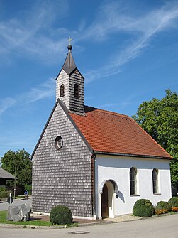
Local chapel
|
||
Mauggen is part of the Bockhorn municipality in the Erding district in Upper Bavaria .
geography
The place is 1.5 kilometers south of Bockhorn on a hill in the tertiary Isar-Inn hill country ( Erdinger Holzland ).
Architectural monuments
In the list of monuments in Bockhorn (Upper Bavaria) , the local chapel is listed, built in 1904, small a hall church with ridge turret .
Transport and public facilities
State road 2084 runs one and a half kilometers south of the village. There is a public transport connection with the MVV bus lines 561 (during the day, Monday to Friday) and 562 (in the evenings and on weekends).
Web links
- Mauggen in the location database of the Bayerische Landesbibliothek Online . Bavarian State Library


