
Sankt Wolfgang (Upper Bavaria)
| coat of arms | Germany map | |
|---|---|---|
_COA.svg)
|
Coordinates: 48 ° 13 ' N , 12 ° 8' E |
|
| Basic data | ||
| State : | Bavaria | |
| Administrative region : | Upper Bavaria | |
| County : | Erding | |
| Height : | 509 m above sea level NHN | |
| Area : | 46.32 km 2 | |
| Residents: | 4480 (Dec. 31, 2019) | |
| Population density : | 97 inhabitants per km 2 | |
| Postcodes : | 84427, 84419 | |
| Primaries : | 08085, 08081, 08072 | |
| License plate : | ED | |
| Community key : | 09 1 77 137 | |
| Community structure: | 7 districts | |
| Address of the municipal administration: |
Hauptstrasse 9 84427 Sankt Wolfgang |
|
| Website : | ||
| Mayor : | Ulrich Gaigl (Free Voters) | |
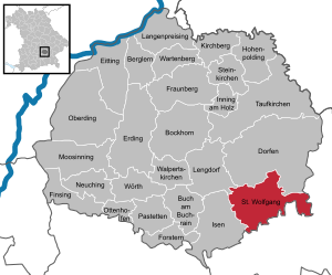
| Location of the municipality of Sankt Wolfgang (Upper Bavaria) in the Erding district | ||
  |
||


Sankt Wolfgang is a municipality in the southeast of the district of Erding ( Upper Bavaria ). The municipality borders the municipalities of Dorfen , Lengdorf and Isen in the district of Erding and Haag and Obertaufkirchen in the district of Mühldorf .
geography
location
The area is largely rural, hilly and partly wooded. The landscape in the east of the municipal area is dominated by the Gattergebirge created from terminal moraines . The village of Sankt Wolfgang is located in the Goldach valley about 27 km southeast of the district town of Erding , 40 km south of Landshut , 23 km north of Wasserburg am Inn and 48 km east of the state capital Munich .
Community structure
Markings are Gatterberg , Jeßling, Lappach, Pyramoos, Sankt Wolfgang, Schönbrunn and Tann.
The parish has 150 parish parts: the parish villages of Sankt Wolfgang and Schönbrunn ; the church villages of Armstorf , Großschwindau , Lappach and Pyramoos ; the village of Kleinschwindau ; the hamlets Arbasstätt , Burdberg , Eiermühle , Frühmannstett , Gänsberg , Gassen , Gumpenstätt , Herrnberg , Holzen , Hub , Jeßling , Kalkgrub , Klaus , Königswinkl , Mammersreit , Mühlberg , Notzing , Oed , Pürstling a.Parstling , Reit , Saxenberg , Schedenberg , Schmidberg , Schönfleck , Semmelhub , Spirkersberg , Steinbach , Stockham , Straßberg , Thal and Unterthalham ; The wastelands of Aign , Alten , Angerl , Anzenberg , Aschau , Baier , Baumgarten , Bennoberg , Bergham , Berndorf , Bichl , Birnbach , Bramer , Brandstett , Braun , Brenner , Dangl , Deischl am Thon , Deyern , Eberhart , Edenklaus , Eichholz , Eisenberg , Endgassen , Erlach , Erlbach , Freiling , Freundl , Friedenheim , Fürth , Geigersöd , Geltenstett , Giglberg , Grabenstätt , Grub , Grünbach , Grundbichl , Haberstätt , Hackl , Hadersberg , Haman , Hammer a.Berg , Hankl , Haubenstett , Hauderstett , Herrnwies , Hiedl , Hilgen , Hilgen a.Weg , Hochreit , Hodersberg , Hohmannsberg , Hohmannstett , wood , wood a.Berg , wood neighbors , Holzweg , Hundsruck , Hungersberg , Hütter , Irlmaier , Irlwirth , Kaltenbrunn , Kiener , Kirchstätt , Kistlmühle , Kohlmühle , Kothholz , Krähmühle , Lehen , Lehner , Leitmannstätt , Lex , Loh , Mayerhof , Mithilgen , Neuwies , Oberthalham , Pumpernudel , Pürstling , Rabeneck , Reisern , Reitermann , Reschenberg , Rindbach , Rudorfer , Sägmühle , Schachen , Scha chner , Schloifer , Schloßöd , Schnurren , Seebäck , Singer , Sollach , Stadler , Stangl , Streichermühle , Strell , Thalham , Ulrich , Weiding , Weinhub , Weinthal , Weizenbach , Wernhardsberg , Wies , Wohlmannstätt , Zeilhub , Zieglhäusl , Zulehen and Zwickl .
history

Legend
In 975 the Regensburg bishop Wolfgang left his bishopric as a result of political turmoil and fled to the Goldachtal . According to a legend written in a papal bull in 1737, the bishop threw a hoe into the valley from the hills east of today's St. Wolfgang. At the point where it fell on the ground, a spring with fresh water was then awakened. Bishop Wolfgang had settled there in a hut ("cell") and thus laid the foundation stone for the town of St. Wolfgang. The so-called Wolfgangsbrünnlein can still be found today in the Wolfgang Chapel, which in turn is located in the St. Wolfgang Church, which was completed in the 15th century.
historical development
The first traces of settlement in the area of today's municipality of St. Wolfgang can be traced back to the Neolithic Age. Centuries later, the Celts and Romans followed, the latter mainly as travelers on a Roman road crossing the municipality from north to south. With the Bavarian land grabbing around the year 500, more intensive agricultural use of the area finally began. According to the legend, the year 975 is regarded as the official founding date of the place St. Wolfgang. The 1000th anniversary was celebrated in 1975.
From 1180, today's parish of St. Wolfgang was ruled by the free imperial counts of Haag , who received the area from the emperor as a fief. During their rule, which lasted until 1566, the imperial counts took care of the construction of the large churches in St. Wolfgang, Großschwindau, Lappach, Pyramoos and Schönbrunn. The counts also held the lower jurisdiction, which is still remembered by inscriptions on the 16th century beamed ceiling of the Gasthaus zum Schex in St. Wolfgang.
In the Thirty Years War (1618–1648), extensive acts of war took place in the municipality, particularly during the so-called “Swedish War” (1630–1635). Battles from the Spanish and Austrian Wars of Succession (1701–1714 and 1741–1748) also took place around St. Wolfgang. The great battle of Hohenlinden in 1800, which Napoléon's General Moreau waged as part of France's war against Austria, also had a direct impact on today's municipality due to its geographical proximity.
Nevertheless, the place and region developed well. In 1733, Elector Karl Albrecht made St. Wolfgang a “closed court marque ”; At the same time, a modest collegiate foundation was founded, which existed until the secularization in 1803. The establishment of a Hofmark was also granted to Schönbrunn a few years later.
The two world wars in the 20th century caused great losses in the population, but the region around St. Wolfgang was spared from fighting and major destruction.
Since the dissolution of the Wasserburg district on July 1, 1972, the municipality of St. Wolfgang has belonged to the Erding district . Ludwig Huber (1922-2006), who was the first mayor of the community from 1966 to 1974, played a major role in the success of this restructuring.
Incorporations
The municipality of St. Wolfgang found its present form on April 1, 1971, when the previously independent municipalities of Gatterberg, Jeßling, Lappach, Pyramoos and Schönbrunn were incorporated. On July 1, 1972, the previously independent municipality of Schiltern was dissolved. The main part came to Dorfen . Less than ten residents moved to the community of St. Wolfgang.
Population development
According to the Bavarian State Office for Statistics , the population figures developed as follows on December 31 of each year:
| was standing | Residents |
|---|---|
| 1960 | 2449 |
| 1970 | 2703 |
| 1980 | 2788 |
| 1990 | 3259 |
| 1995 | 3587 |
| 2000 | 3870 |
| 2005 | 4187 |
| was standing | Residents |
|---|---|
| 2006 | 4189 |
| 2007 | 4244 |
| 2008 | 4278 |
| 2009 | 4288 |
| 2010 | 4312 |
| 2011 | 4254 |
| 2012 | 4278 |
| was standing | Residents |
|---|---|
| 2013 | 4340 |
| 2014 | 4404 |
| 2015 | 4426 |
| 2016 | 4433 |
Since 1972, the year of the municipal reform, the population has increased by 1679 people until 2015. This corresponds to a growth of 61.12 percent. In the last ten (five) years the population increased by 5.66 (4.04) percent.
Since the nineties in particular, the community has seen a very strong increase in population. This is mainly concentrated on the parts of the municipality Sankt Wolfgang itself and Armstorf, while the population in other parts of the municipality has barely increased or (as in Gatterberg and Pyramoos ) is declining.
| year | gang mountain |
Jeßling | Lappach | pyramidal moss |
perfecting brunn |
Poor peat |
wholesale schwindau |
St. Wolfgang (village) |
Total number |
|---|---|---|---|---|---|---|---|---|---|
| 1912 | 279 | 330 | 383 | 265 | 271 | 83 | 138 | 679 | 2428 |
| 1933 | 262 | 337 | 385 | 268 | 252 | 757 | 2261 | ||
| 1939 | 258 | 302 | 326 | 259 | 264 | 822 | 2231 | ||
| 1950 | 327 | 427 | 459 | 325 | 350 | 127 | 137 | 887 | 3039 |
| 1961 | 233 | 308 | 347 | 280 | 222 | 245 | 155 | 738 | 2510 |
| 1978 | 212 | 422 | 327 | 262 | 246 | 412 | 128 | 691 | 2700 |
| 2010 | 170 | 480 | 389 | 226 | 235 | 1007 | 122 | 1662 | 4291 |
| 2011 | 163 | 476 | 399 | 241 | 238 | 1036 | 127 | 1745 | 4425 |
The significant increase in the number of residents after the Second World War can be explained by the influx of displaced persons. The sudden increase for Jeßling between 1961 and 1978 is due to the construction of the Wolfgang retirement home.
Between 1988 and 2018 the municipality grew from 3,100 to 4,479 by 1,379 inhabitants or 44.5%.
politics
Municipal council
The municipal council consists of 16 members, of which 7 belong to the CSU, 5 independent groups of voters , 3 to the free voters and one to the SPD .
mayor
The honorary first mayor of the community was Jakob Schwimmer ( CSU ), who was also a member of the Bavarian State Parliament from 2003 to 2013 and was confirmed with around 75% of the votes in the last local election in 2008 . In the local elections in March 2014, Ullrich Gaigl (Free Voters) was elected mayor. Second mayor is Konrad Bernhard (CSU) from the Gatterberg voter group / Free voter community Schönbrunn.
Partner municipality
In Austria there is a place of the same name on Lake Wolfgang , St. Wolfgang in the Salzkammergut . The places are partner communities.
badges and flags
The coat of arms of the parish of St. Wolfgang was laid down on June 12, 1973: “Wavy divided by red and silver; above a silver horse's trunk, below a sloping blue ax. "
The horse's trunk is the heraldic mark of the Count Fraunberger zu Haag and indicates that it was part of the imperial county of Haag. The hoe in the lower part of the coat of arms refers to the legend of Bishop Wolfgang. The spring awakened by him is also symbolized by the wave division of the two parts of the coat of arms.
In addition to the coat of arms, the municipality carries a flag with the colors blue-white-blue.
Eastern Alliance
The community participates in the Eastern Alliance .
Economy and Infrastructure
From an economic point of view, St. Wolfgang benefits in particular from its proximity to Munich and a branch of the Cerner company . In addition, the community is still strongly characterized by agriculture, with a consistently low unemployment rate. In addition to the relatively good connection to the federal road network, the (almost) central location between Erding, Wasserburg and Mühldorf on the one hand and between Landshut, Rosenheim and Munich on the other hand is an important locational advantage.
There are two banks in St. Wolfgang: the Raiffeisenbank St. Wolfgang-Schwindkirchen eG with an additional branch in Schönbrunn and a branch of the Kreis- und Stadtsparkasse Wasserburg . Parts of the municipality of St. Wolfgang are connected to a wood-carved biomass heating plant.
There was a brewery in St. Wolfgang since 1691, but the Bauer brewery had to close in 2003. The S. Numberger KG brewery only existed from 1928 to 1968 and was continued in the following years as a beer and beverage sales, malt house and metal construction company.
education
In the parish of St. Wolfgang there is one kindergarten run by the Catholic Church (Sankt Wolfgang) and two run by the parish (Armstorf and Waldkindergarten Lappach). Since 2011 there has also been a crèche facility for children under 3 years of age in the St. Wolfgang Kindergarten.
The primary school can be attended by children from the community in St. Wolfgang, as well as grades 5 and 6 of the secondary secondary school. At the beginning of the 2003/2004 school year, 265 students were enrolled at the St. Wolfgang primary and secondary school, for which 15 teachers are available. At the beginning of the 2010/11 school year, 190 students and 16 teachers were counted.
Secondary schools are in the neighboring communities: secondary schools in Dorfen, Isen and Haag in Upper Bavaria , secondary schools in Taufkirchen / Vils and Haag / Obb., Grammar schools in Erding, Dorfen, Gars / Inn and Wasserburg as well as vocational schools in Erding, Mühldorf and Wasserburg.
traffic
Streets
The community is crossed from north to south by the federal highway 15 (the route German holiday route Alps – Baltic Sea ) on its way from Landshut (40 km) to Rosenheim (45 km). Via the nearby B 12 and A 94 it is around 50 km to the state capital Munich , to the district town of Erding it is around 25 km past Dorfen. Together with the subordinate roads, the municipality has a total of 62.1 km of public roads outside of the city. In addition to the state road St 2086 ( Ebersberg -Dorfen), this also includes the district roads ED 18, ED 21, ED 22 and ED 23.
railroad
St. Wolfgang had a connection to the rail network from 1900 to 1974 (passenger traffic until 1968) with the station in Pyramoos on the Thann-Matzbach-Haag line . The route has now been dismantled. Numerous commuters from the municipality of St. Wolfgang also use the rail connection from the neighboring municipality of Dorfen to Munich.
buses
The public transport offer in the municipality of St. Wolfgang is small. In addition to school bus routes, there is also bus route 567 (Dorfen - St. Wolfgang - Isen - Erding), which runs every one to two hours from Monday to Friday. The tariff of the Münchner Verkehrs- und Tarifverbund (MVV) applies . There is a train connection from Dorfen to Munich. In addition, Sankt Wolfgang is connected to the bus line 82 ( Gars am Inn -Dorfen) and to the connection 9409 (Wasserburg am Inn-Dorfen) of the regional traffic of Upper Bavaria . However, these lines only run on working days in the morning, sometimes at noon and in the evening.
Culture and sights
Architectural monuments

The parish and pilgrimage church of St. Wolfgang was consecrated in 1484; it includes the well chapel built after 1400. The church is a two-aisled late Gothic wall pillar construction , according to Dehio it is "one of the best examples of late Gothic brick building in Old Bavaria". The three-bay choir has a three-eighth end, the nave has four bays. The older chapel is closed on three sides, with a three-bay side chapel in front of it. The tower crowned by a pointed helmet with corner attachments is around 70 m high. The church was stuccoed by Christoph Schäffler with the assistance of Johann Baptist Zimmermann . The room-filling high altar from 1679 has carved figures of saints Wolfgang, Georg and Sigismund in the middle shrine, and wooden reliefs on the side wings with depictions from the legend of Wolfgang from the late Gothic high altar by Heinrich Helmschrot from Landshut . Four panel paintings of the old high altar with scenes from the life of the Virgin are hung in the choir, in the nave, two further reliefs (Annunciation and Adoration of the Child). The cross altar on the south wall of the aisle contains a multi-figure wooden crucifixion relief from around 1480.

In front of the church is the Wolfgang fountain designed by Hans Huschka in the Hofmark .
The town hall is housed in the former provost and dean's court of Johann Baptist Gunetzrhainer from 1737, who served as a canon collegiate monastery from 1737 to 1803. Before the building became the town hall, it housed the rectory with an attached school. In spring 2005, the building was thoroughly renovated in keeping with the style.
In the Gasthaus zum Schex there is a Gothic-style beamed ceiling from the second half of the 16th century.
Parts of the village as well as the Hofmark in the center of the municipality are attractive. In 2006, St. Wolfgang won the bronze medal at the district level in the competition Our village has a future - our village should become more beautiful .
Nature reserves
- Erratic block near Sollach (geotope number 177R001)
free time activities
- Voluntary fire brigades: 1 base fire brigade (in Sankt Wolfgang) and 5 local fire brigades (in Gatterberg, Jessling, Lappach, Pyramoos and Schönbrunn) in the municipality of St. Wolfgang. There is a youth fire brigade in St. Wolfgang and Pyramoos. Schönbrunn has a joint local fire brigade with the Kirchdorf district of Fürholzen.
- There is also a gymnastics and sports club, a horticultural club, several shooting clubs and a music club (including a brass band). The clubs have a youth department.
- The rural people's movement is strongly anchored in the rural parts of the municipality .
tourism
Although it belongs to the most scenic areas of the district with the Goldachtal and the Gattergebirge , St. Wolfgang is hardly developed from a tourist point of view. As a place of pilgrimage, St. Wolfgang has lost much of its importance. There is a noticeable number of day tourists (through the Gasthaus zum Schex ), but only relatively few accommodation options in the districts of St. Wolfgang, Lappach , Endgassen, Baier (both in Jeßling ) and Edenklaus (Pyramoos). This offer is partly due less to tourism than to the relative proximity to Munich .
Personalities
- Jakob Schwimmer , German politician (CSU), former mayor of St. Wolfgang and former MdL. Is the former mayor of St. Wolfgang. Is now the second district administrator in the Erding district.
Individual evidence
- ↑ "Data 2" sheet, Statistical Report A1200C 202041 Population of the municipalities, districts and administrative districts 1st quarter 2020 (population based on the 2011 census) ( help ).
- ^ Community of Sankt Wolfgang in the local database of the Bavarian State Library Online . Bavarian State Library, accessed on November 6, 2017.
- ↑ merkur-online.de: Ludwig Huber brought the large community together
- ^ Wilhelm Volkert (ed.): Handbook of Bavarian offices, communities and courts 1799–1980 . CH Beck, Munich 1983, ISBN 3-406-09669-7 , p. 589 .
- ↑ Bavarian State Office for Statistics: 12111-101z Census and population update: municipality, population (census and current), reference dates . Online at www.statistikdaten.bayern.de. Retrieved August 17, 2016.
- ^ Numbers from Meyer's Orts- und Verkehrslexikon, 5th edition, 1912/13
- ^ Michael Rademacher: German administrative history from the unification of the empire in 1871 to the reunification in 1990. Landkreis Wasserburg am Inn. (Figures for 1933 and 1939; online material for the dissertation, Osnabrück 2006).
- ↑ Figures from the Bavarian State Statistical Office (publisher): Official local directory for Bavaria - edited on the basis of the census of September 13, 1950 . Issue 169 of the articles on Bavaria's statistics. Munich 1952, DNB 453660975 , Section II, Sp. 332-333 ( digitized version ).
- ↑ Merkur of May 12, 2006: St. Wolfgang wins bronze in the village competition
- ↑ See the information in the text Andreas Stamml: Pilgrimage from Großschwindau (St. Wolfgang parish) to Maria Dorfen (PDF; 210 kB)
Web links
- Entry on the coat of arms of Sankt Wolfgang (Upper Bavaria) in the database of the House of Bavarian History
Armstorf | Gatterberg | Großschwindau | Jeßling | Kleinschwindau | Lappach | Pyramoos | Saint Wolfgang | Schönbrunn

Mountain learning | Bockhorn | Buch am Buchrain | Dorfen | Eitting | Erding | Finsing | Forstern | Fraunberg | Hohenpolding | Inning on wood | Isen | Kirchberg | Long price | Lengdorf | Moosinning | Neuching | Oberding | Ottenhofen | Patties | Saint Wolfgang | Stone churches | Taufkirchen (Vils) | Walpert Churches | Wartenberg | Wörth