
Obertaufkirchen
| coat of arms | Germany map | |
|---|---|---|

|
Coordinates: 48 ° 16 ' N , 12 ° 17' E |
|
| Basic data | ||
| State : | Bavaria | |
| Administrative region : | Upper Bavaria | |
| County : | Mühldorf am Inn | |
| Height : | 457 m above sea level NHN | |
| Area : | 31.65 km 2 | |
| Residents: | 2584 (Dec. 31, 2019) | |
| Population density : | 82 inhabitants per km 2 | |
| Postal code : | 84419 | |
| Area code : | 08082 | |
| License plate : | MÜ, VIB , WS | |
| Community key : | 09 1 83 135 | |
| LOCODE : | DE ZBX | |
| Community structure: | 82 districts | |
| Address of the municipal administration: |
Am Sportplatz 5 84419 Obertaufkirchen |
|
| Website : | ||
| Mayor : | Franz Ehgartner ( loyalty to home ) | |
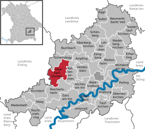
| Location of the community Obertaufkirchen in the district of Mühldorf am Inn | ||
  |
||

Obertaufkirchen is a municipality in the Upper Bavarian district of Mühldorf am Inn .
geography
Geographical location
Obertaufkirchen is in the region of southeast Upper Bavaria and is partly in the Isental. The municipality is crossed by three valleys: the Rimbachtal, the Ornautal with the Ornaubach, which has been regulated since the 1960s, and the Kagental with the Kagenbach.
Community structure
The municipality of Obertaufkirchen has 82 districts:
There are the districts of Oberornau and Obertaufkirchen. The Rimbachau district was not built as a holiday resort until the 1970s. It is built on with so-called Swedish houses (wooden construction and pointed roof to the ground). Before that time it was the Au von Rimbach with no name or development.
history
Until the church is planted
Obertaufkirchen was part of the Landshut Rent Office and the Neumarkt Regional Court of the Electorate of Bavaria . By the chairman shaft Obertaufkirchen the archbishopric exercised Salzburg from the lower jurisdiction over its local subjects until its repeal in 1,803th In the hamlet of Hohenthann, a few meters to the northeast, there was an impressive castle as the Wening engraving from 1710 shows, but there it was already in ruins. In the course of the administrative reforms in Bavaria , today's municipality was created with the municipal edict of 1818 .
Population development
Between 1988 and 2018 the municipality grew from 1,759 to 2,591 by 832 inhabitants or 47.3%.
- 1961: 1637 inhabitants
- 1970: 1682 inhabitants
- 1987: 1722 inhabitants
- 1991: 2016 inhabitants
- 1995: 2220 inhabitants
- 2000: 2329 inhabitants
- 2005: 2403 inhabitants
- 2010: 2427 inhabitants
- 2015: 2555 inhabitants
politics
Acting Mayor
Mayor is Franz Ehgartner (Heimattreue). Previous mayor: Rudolf Hartinger Obertaufkirchen Sebastian Bauer Obertaufkirchen Mesmering
coat of arms
Description: In the silver heraldic shield, set off by a shield head with a blue and white two-row cloud pole , there is a blue wave bar above which a red baptismal font lies.
Churches
The parish church of Obertaufkirchen is dedicated to St. Saint Martin and St. Magdalena consecrated.
The large house of worship combines a remarkable number of different styles. Visible parts (e.g. portal ) have even been preserved from the first stone building in the Romanesque style, built around 1150 , as well as from the late Gothic successor, which came into being from 1450. The baroque and rococo design followed around 1777. 1910–1911 the front nave and the choir were enlarged in the area of the front nave and the choir was built in the neo-baroque style.
The Frauenornau branch church is St. Consecrated to Mary (Visitation of Mary).
It was a popular pilgrimage church from very early on. It is a late Gothic building with an impressive Rococo interior from 1774.
The Annabrunn branch church is St. Consecrated to Anna.
The noble Frau von Fugger owner of Schwindeck Castle had this monument built for the first time as a chapel in 1686 in order to give the pilgrims who visited the Annabrünnlein the possibility of a spiritual contemplation. The chapel was expanded just a year later.
The Kirchkagen branch church is dedicated to St. Consecrated Peter.
This late Gothic church in the hamlet of Kirchkagen is also worth seeing.
Economy and Infrastructure
Economy including agriculture and forestry
At the place of work there were 38 employees subject to social security contributions in the field of agriculture and forestry, 336 in the manufacturing sector and 42 in trade and transport. In other economic sectors, 87 people were employed at the place of work subject to social security contributions. There were a total of 696 employees at the place of residence subject to social security contributions. There were two companies in the manufacturing sector (as well as mining and quarrying of stones and earth), and six in the construction industry. In addition, in 1999 there were 126 farms with an agricultural area of 2186 ha. Of this, 1222 ha were arable land and 963 ha were permanent green space. A center for metal processing was established in the Steinkirchen district in the 1970s by the local company Grundner Lüftungsbau. In the meantime, 3 individual companies have emerged from this company.
traffic
The A 94 Munich-Passau motorway runs one kilometer south of Obertaufkirchen and the connection is via the MÜ 22 district road with the Schwindegg junction (16). The A 94 cuts through the municipality over a length of 3.8 kilometers in an east-west direction with cuts and two large bridges. The controversial route section Pastetten-Heldenstein was opened to traffic on October 1, 2019.
The district road MÜ 22 is an important regional connecting road in north-south direction.
education
The following institutions exist (as of: 1999):
- Kindergartens: 75 kindergarten places with 88 children
- Elementary schools: one with 15 teachers and 248 students
Personalities
- Georg Konrad Huber (born January 6, 1950), politician and district administrator born in Obertaufkirchen
- Peter Jaschke (born March 1, 1952), former national handball goalkeeper, born in Obertaufkirchen
- Franz Feckl (born November 17 1955), in Obertaufkirchen born chef, with a star in the Michelin guide awarded
Individual evidence
- ↑ "Data 2" sheet, Statistical Report A1200C 202041 Population of the municipalities, districts and administrative districts 1st quarter 2020 (population based on the 2011 census) ( help ).
- ↑ http://www.bayerische-landesbibliothek-online.de/orte/ortssuche_action.html ? Anzeige=voll&modus=automat&tempus=+20120105/155435&attr=OBJ&val= 413
- ↑ http://steffenvoelkel2.de/24.november.2010%20073.jpg ( page no longer available , search in web archives ) Info: The link was automatically marked as defective. Please check the link according to the instructions and then remove this notice.
Web links
- Obertaufkirchen community
- Parish Association Obertaufkirchen
- Entry on the coat of arms of Obertaufkirchen in the database of the House of Bavarian History
Aign | Angermühle | Annabrunn | Bogenberg | Brandstätt | Breitenau | Brunn | Deutheim | Distlberg | Dornmühle | Ebering | Etz | Forest lift | Frauenornau | Friedlrimbach | Gaßlhub | Grüngiebing | Grünwald | Haindlschuster | Haslberg | Hiller | Hillermaurer | Hirschstätt | Hitzling | Hofgiebing | Hohenpoint | Hohenthann | Höllhof | Wood | Woodland | Hut | Caries | Kielöd | Kirchkagen | Lacquers | Lentfelden | Linden | Corn | Manhartsberg | Marx am Holz | Mesmering | Mimmelheim | Mitterrimbach | Neuhausen | Niederham | Niedermühle | Oberbergham | Oberöd | Oberornau | Oberrimbach | Oberschwarzenbach | Obertaufkirchen | Oberthalham | Upper Vineyard | Oed | Paunzenhofen | Pfaffenkirchen | Rabeneck | Rampoldsheim | Ratzenberg | Reinthal | Reuth | Rimbachau | All around | Schwarzenbach | Stone churches | Set | Stierberg | Pen | Stick riding | Stockweb | Strass | Thalham | Unteröd | Vogldorn | Pond | Vineyard | Continue milling | Wendenheim | Wies | Wiesreit | Winharting

Ampfing |
Aschau am Inn |
Buchbach |
Egglkofen |
Erharting |
Gars am Inn |
Hague in Upper Bavaria |
Hero's Stone |
Jettenbach |
Kirchdorf |
Kraiburg am Inn |
Lohkirchen |
Maitenbeth |
Mettenheim |
Mühldorf am Inn |
Neumarkt-Sankt Veit |
Niederbergkirchen |
Niedertaufkirchen |
Oberbergkirchen |
Oberneukirchen |
Obertaufkirchen |
Polling |
Rat churches |
Right more |
Reichertsheim |
Schoenberg |
Schwindegg |
Taufkirchen |
Unterreit |
Waldkraiburg |
Zangberg
Unregulated areas in the district of Mühldorf a.Inn
Mühldorfer Hart